
Kentucky and Tennessee Face Gusty Showers Thursday as Severe Risk Downgraded to General Thunderstorms
KENTUCKY AND TENNESSEE — Forecasters are monitoring a gusty but low-end storm system expected to move across southern Kentucky and Middle Tennessee on Thursday, after the Storm Prediction Center downgraded the region’s severe weather outlook to a “General Thunderstorm” risk.
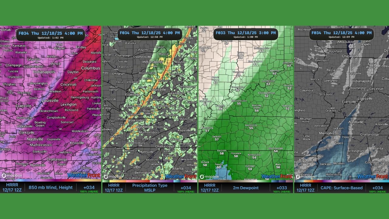
Latest forecast graphics show widespread showers with embedded stronger cells, but limited instability and moisture are expected to prevent a widespread severe outbreak.
Severe Weather Risk Reduced, But Strong Gusts Still Possible
According to the updated outlook, the earlier Level 1 out of 5 severe risk has been removed, replaced by a general thunderstorm designation. While thunderstorms are still expected, low CAPE values and limited storm moisture should keep most activity below severe thresholds.
However, forecasters note that strong winds aloft around 5,000 feet may mix down to the surface as the system moves through.
As a result, wind gusts of 25 to 35 mph are likely across parts of southern Kentucky and Middle Tennessee, especially along and ahead of the main line of showers.
Isolated Strong Storms Still Possible
While the overall risk is lower, the data indicates that isolated stronger storms could briefly develop, particularly in southern Kentucky and central portions of Middle Tennessee.
These storms would not be driven by classic instability, but rather by wind energy and pressure gradient increases, which may allow a few cells to briefly intensify.
Forecasters stress that widespread severe weather is not expected, but residents may still experience brief heavy rain, gusty winds, and lightning.
Rain Line Moves Through by Afternoon
Model guidance shows a broken line of showers and thunderstorms advancing eastward through:
- Southern Kentucky
- Middle Tennessee, including the Nashville area
Rain coverage appears scattered to widespread, but rainfall intensity should remain moderate overall.
Colder Air Follows, Possible Wintry Mix in Kentucky
Behind the system, colder air will move in Thursday night, leading to a noticeable temperature drop.
Forecast data suggests a low-end chance for a brief wintry mix on the backside of the system in parts of Kentucky, though no accumulation or travel impacts are currently indicated.
What Residents Should Expect
- Periods of showers Thursday
- Occasional thunder
- Wind gusts up to 35 mph
- Cooler temperatures Thursday night
- Very low severe storm risk
Residents are advised to secure loose outdoor items and remain weather-aware during the passage of the rain line.
WaldronNews.com will continue to monitor forecast updates and provide timely weather coverage as conditions evolve.