
Line of Severe Storms With Supercells and Tornado Potential Tracks From Eastern Mississippi Toward Alabama
MISSISSIPPI–ALABAMA — A dangerous line of severe thunderstorms, including rotating supercells, was actively tracking across eastern Mississippi and moving east toward Alabama on Wednesday evening, with radar confirming multiple mesocyclones and at least one brief tornado detected earlier by radar.
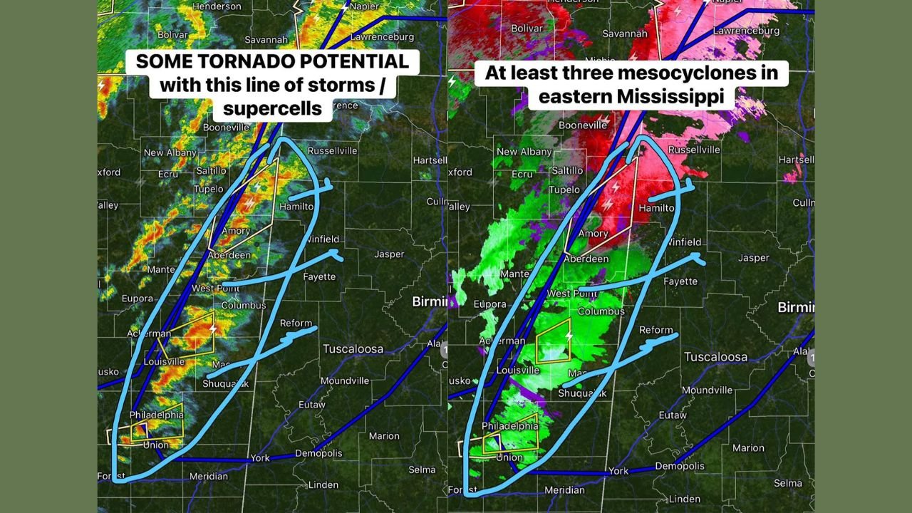
Meteorological analysis of radar imagery shows a well-organized storm line extending from northern Mississippi southward through the central and eastern portions of the state, with storms intensifying as they move east-northeast.
Multiple Mesocyclones Identified Across Eastern Mississippi
Radar velocity and reflectivity data indicate at least three distinct mesocyclones embedded within the storm line across eastern Mississippi, particularly from the Amory area south through Aberdeen, West Point, Columbus, Louisville, and Philadelphia.
The strongest areas of rotation were highlighted within several storm cells showing clear supercell characteristics, including persistent rotation signatures and enhanced reflectivity cores. These features suggest an environment capable of producing tornadoes and damaging straight-line winds.
Brief Tornado Confirmed by Radar Earlier
Earlier radar scans confirmed a brief tornado, detected by strong low-level rotation within one of the supercell structures. While the duration appeared short, the presence of multiple rotating storms increases the risk for additional tornado development as the line continues eastward.
Storms exhibiting these rotation signatures were observed near Philadelphia and Union, as well as northward toward Aberdeen and Amory, before progressing toward the Alabama state line.
Storm Line Advancing Toward Alabama This Evening
The entire storm complex is moving east toward Alabama, maintaining strong organization. Radar imagery shows the line remaining intact, with additional storms developing along and just ahead of the main boundary.
Communities in western Alabama should be prepared for strong to severe thunderstorms, including the potential for:
- Tornadoes
- Damaging wind gusts
- Intense lightning
- Heavy rainfall
The storm structure suggests that supercell activity may persist as the line enters Alabama, particularly during the evening hours.
Residents Urged to Stay Weather-Aware
With confirmed mesocyclones and radar-indicated tornado activity, residents across eastern Mississippi and western Alabama are urged to closely monitor weather conditions and be ready to take shelter quickly if warnings are issued.
This evolving severe weather situation remains dynamic, and conditions can change rapidly as storms progress eastward.
WaldronNews.com will continue tracking this developing storm system and provide updates as new information becomes available.