
New York, New Jersey, and Connecticut Winter Storm Brings Heavy Snow to NYC, Long Island, and Lower Hudson Valley Through Saturday Morning
NEW YORK — A widespread winter storm is impacting the New York City metro area, Long Island, the Lower Hudson Valley, northeastern New Jersey, and much of Connecticut, with moderate to heavy snowfall expected from late Friday afternoon through Saturday morning. National Weather Service briefings indicate this system will produce plowable snow, hazardous travel, and periods of reduced visibility, especially during the evening and overnight hours.
The heaviest snow is forecast to fall Friday evening into the overnight period, when snowfall rates could exceed 1 inch per hour in stronger bands.
Winter Storm Warnings and Advisories in Effect
Winter Storm Warnings are in place for:
- New York City
- Northeastern New Jersey
- Lower Hudson Valley
- Nassau County
- Western Suffolk County
- Fairfield County, Connecticut
- New Haven County, Connecticut
Winter Weather Advisories cover parts of:
- Eastern Suffolk County, NY
- Middlesex County, CT
- New London County, CT
Warnings are generally valid from late Friday afternoon through early Saturday afternoon, while advisories extend into Saturday midday.
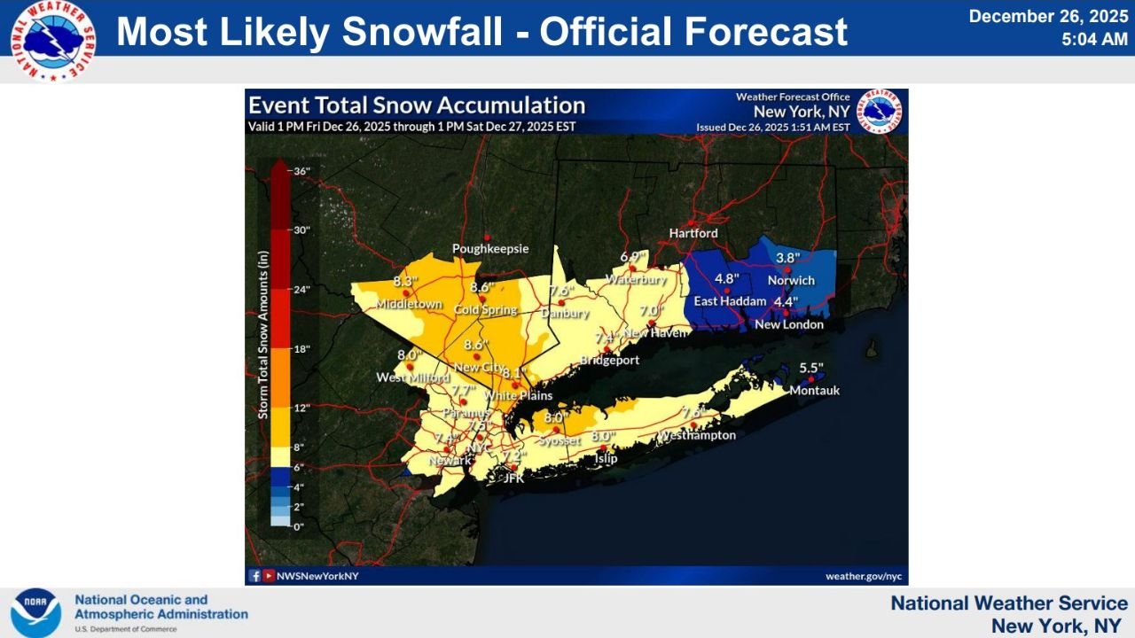
Expected Snowfall Totals by Region
Forecast snowfall maps show a broad swath of 5–9 inches across the core warning area, with localized higher amounts where heavier snow bands persist.
Most likely snowfall totals include:
- New York City: 6–9 inches
- Lower Hudson Valley (Westchester, Rockland, Putnam): 7–9 inches
- Northeastern New Jersey: 5–8 inches
- Nassau County & Western Suffolk: 6–8 inches
- Eastern Long Island (Montauk area): 4–6 inches
- Southwestern Connecticut: 6–8 inches
- Eastern Connecticut: 3–5 inches
Some isolated areas could exceed 10 inches if heavier bands remain stationary for several hours.
Snowfall Rates and Impacts
During the peak of the storm:
- Snowfall rates of 1–2 inches per hour are possible
- Brief bursts could exceed 2 inches per hour in localized bands
- Visibility may drop rapidly during heavier snowfall
Road conditions are expected to deteriorate quickly, particularly on bridges, untreated secondary roads, and during evening travel.
Snow Type and Temperatures
Forecasters expect:
- Dry, powdery snow Friday evening
- A transition to slightly wetter snow overnight into Saturday morning
- Temperatures in the mid to upper 20s, cold enough to keep snow accumulating efficiently
Some uncertainty remains regarding the exact placement of the heaviest snow bands, and totals could be slightly lower in areas where sleet briefly mixes in.
Travel and Safety Concerns
Significant travel disruptions are likely across the region:
- Snow-covered and slippery roads
- Reduced visibility during heavier bands
- Slower commute times Friday evening and early Saturday
Residents are urged to limit unnecessary travel, allow extra time if driving is unavoidable, and prepare for changing conditions overnight.
Bottom Line
A high-impact winter storm is bringing widespread accumulating snow to New York City, Long Island, northeastern New Jersey, and much of Connecticut, with 5–9 inches expected in many areas and locally higher totals possible. The most dangerous conditions will occur Friday evening through early Saturday, when snowfall rates peak and travel becomes hazardous.
WaldronNews.com will continue tracking this storm and provide updates as snowfall totals and impacts become clearer.