
Washington Weather Update: Lowland Snow Unlikely as Cooler Air Arrives Overnight, but Icy Spots Possible by Saturday Morning
WASHINGTON — Talk of snow reaching the lowlands has prompted increased attention across western Washington, but updated guidance shows that significant lowland snow accumulation is unlikely, even as cooler air moves in late Friday night and early Saturday, according to the National Weather Service office in NWS Seattle.
While a brief rain–snow mix cannot be ruled out in a few isolated areas as precipitation tapers off, forecasters say ground temperatures remain too warm to support meaningful accumulation across most lowland communities, including the Seattle metro area.
Mountains to See Significant Snowfall
Snow is expected to remain primarily a mountain-focused event, with conditions deteriorating at higher elevations.
Forecasters indicate:
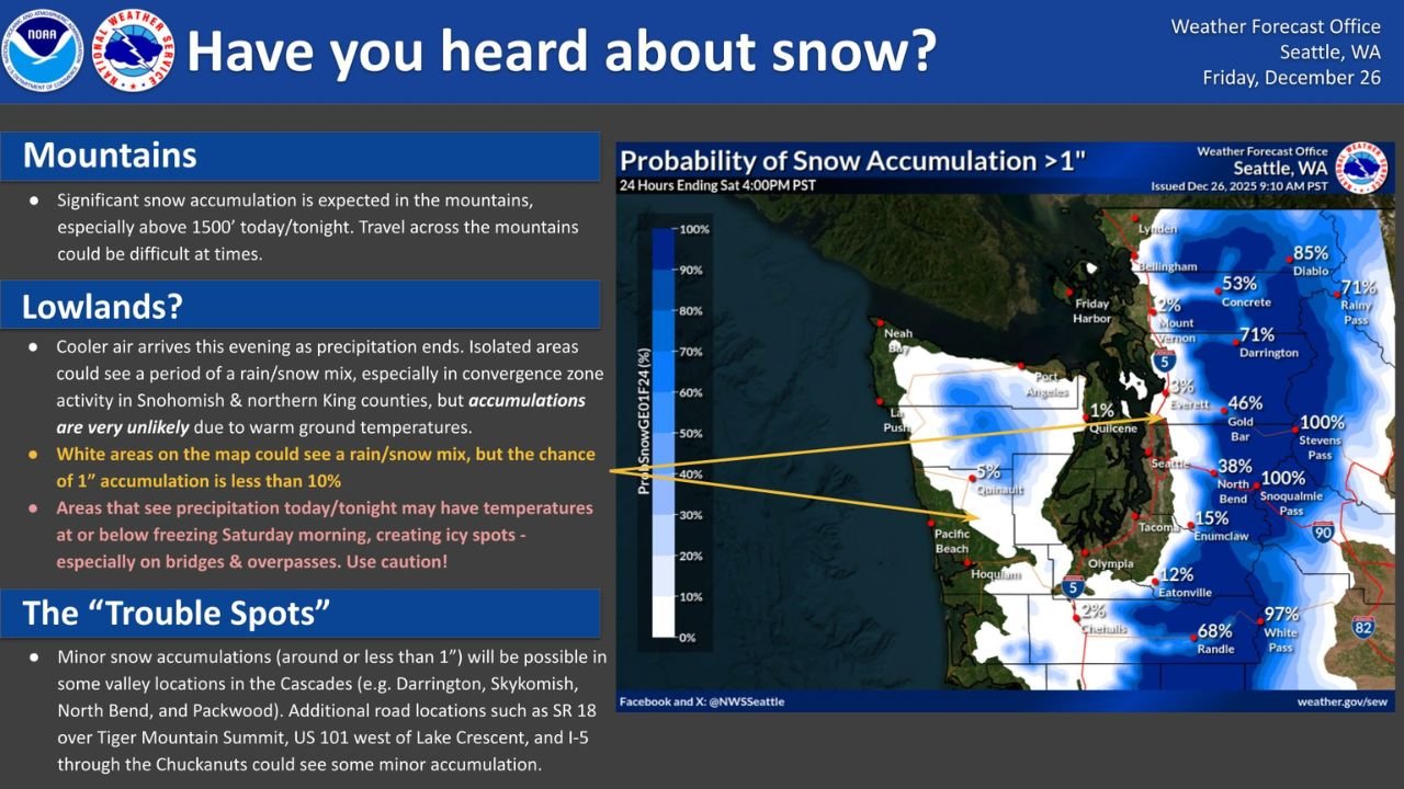
- Significant snow accumulation in the mountains
- Greatest impacts above 1,500 feet through tonight
- Periods of difficult travel over mountain passes
Drivers traveling across the Cascades should be prepared for winter driving conditions, including snow-covered roads and reduced visibility at times.
Lowlands: Rain–Snow Mix Possible, Accumulation Unlikely
As colder air filters in overnight, a short-lived rain–snow mix may develop in parts of the lowlands, especially in areas affected by convergence zone activity.
According to forecast details:
- Isolated rain–snow mix possible in Snohomish County and northern King County
- Chance of 1 inch of accumulation is less than 10% in most lowland areas
- Warm ground temperatures will limit snow buildup
Most locations will see precipitation end before temperatures drop enough to allow snow to accumulate.
Icy Spots Possible Early Saturday
Even without accumulating snow, forecasters warn that wet roads could freeze as temperatures fall toward or below freezing by Saturday morning.
Potential trouble areas include:
- Bridges and overpasses
- Shaded roadways
- Areas that receive precipitation late Friday night
Drivers are urged to use caution during the early morning hours, when isolated slick spots could form unexpectedly.
“Trouble Spots” to Monitor
While widespread lowland snow is not expected, minor accumulations — generally around or under 1 inch — remain possible in a few localized areas.
These include:
- Cascade valley locations such as Darrington, Skykomish, North Bend, and Packwood
- SR-18 over Tiger Mountain Summit
- US-101 west of Lake Crescent
- Portions of I-5 through the Chuckanuts
These locations are more susceptible due to elevation, terrain, and colder localized air pockets.
Timing Overview
- Precipitation tapers off: Friday evening
- Coldest temperatures: Late Friday night into Saturday morning
- Primary concern: Isolated icy spots rather than snow accumulation
Conditions are expected to gradually improve later Saturday as temperatures rise.
What Residents Should Expect
For most of western Washington’s lowlands, this system will be more of a cold and wet-to-icy transition rather than a true snow event. Mountain travelers, however, should remain alert for winter driving conditions.
Stay with WaldronNews.com for continued updates on Washington weather, including mountain travel advisories, overnight temperature trends, and any changes to snow or ice forecasts as conditions evolve.