
Michigan Winter Storm Watch Issued for Upper Peninsula as 5–13 Inches of Snow and 45 MPH Winds Could Create Whiteout Travel Conditions Sunday–Monday
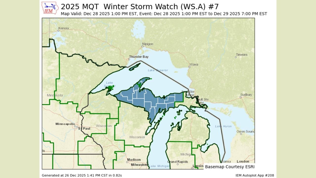
MICHIGAN — A Winter Storm Watch has been issued for nearly the entire Upper Peninsula of Michigan, with forecasters warning that a powerful winter system could bring 5 to 13 inches of snow, wind gusts up to 45 mph, and dangerous whiteout travel conditions beginning Sunday afternoon and lasting into Monday evening.
According to the National Weather Service office in Marquette, the watch goes into effect Sunday at 1 p.m. EST and remains in place through 7 p.m. Monday, covering all counties in the Upper Peninsula except Chippewa and Mackinac counties.
Heavy Snow and Strong Winds Expected Across Most of the U.P.
Meteorologists say the developing storm system will track across the Upper Great Lakes, pulling in moisture from Lake Superior while strengthening surface winds across northern Michigan.
Forecast guidance indicates:
- Snowfall totals between 5 and 13 inches are possible across much of the Upper Peninsula
- Wind gusts up to 45 mph could accompany the snow
- Blowing and drifting snow may significantly reduce visibility
The combination of heavy snowfall and strong winds raises concern for near-blizzard or whiteout conditions, particularly in open and rural areas.
Whiteout Conditions Could Make Travel Dangerous or Impossible
Officials warn that travel conditions may deteriorate rapidly once the storm intensifies. Blowing snow could cause visibility to drop to near zero at times, especially Sunday night into Monday.
Drivers should be prepared for:
- Snow-covered and icy roads
- Rapidly changing visibility
- Road closures or impassable highways
- Delays to emergency services
Forecasters caution that travel could become difficult to impossible during the peak of the storm, particularly for long-distance or overnight travel.
Counties Included and Excluded From the Watch
The Winter Storm Watch applies to nearly all of NWS Marquette’s county warning area, which includes the majority of the Upper Peninsula.
The only counties not currently included in the watch are:
- Chippewa County
- Mackinac County
Officials note that forecast updates could still expand or adjust the watch area as the storm’s track becomes clearer.
What Happens Next: Warnings Likely if Confidence Increases
A Winter Storm Watch means that significant winter weather is possible, but exact impacts are still being refined. If forecast confidence increases, the watch could be upgraded to a Winter Storm Warning or Blizzard Warning.
Residents across the Upper Peninsula are urged to:
- Monitor updated forecasts through the weekend
- Prepare emergency kits and winter travel supplies
- Avoid unnecessary travel during peak storm periods
Stay Weather-Aware
Forecasters emphasize that small changes in storm intensity or track could significantly affect snowfall totals and wind strength. Additional advisories, warnings, or upgrades are likely as the system approaches.
WaldronNews.com will continue tracking this developing winter storm and provide updates as new information becomes available.