
Indiana and Kentucky Line of Storms Expected to Bring 40–60 MPH Damaging Wind Gusts Late Sunday Into Overnight, Forecasters Warn
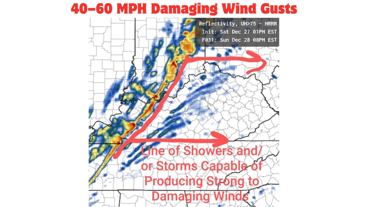
WALDRON, INDIANA — A fast-moving line of showers and storms is expected to sweep across Indiana and Kentucky late Sunday evening into the overnight hours, bringing the potential for strong to locally damaging wind gusts as it pushes east through the Ohio Valley, according to the latest high-resolution model data.
Meteorologists analyzing short-range guidance say this system may behave similarly to the December 18 wind event, but with stronger upper-level support, increasing the likelihood that some storms could efficiently mix high winds down to the surface.
Timing: When The Storm Line Arrives
Forecast guidance indicates the storm line will enter western Indiana and western Kentucky Sunday evening, then progress eastward through central and eastern portions of both states overnight.
- Western Indiana / Western Kentucky: Late Sunday evening
- Central Indiana & Central Kentucky: Late evening to near midnight
- Eastern Indiana & Eastern Kentucky: After midnight into early Monday
The storms are expected to move quickly, limiting rainfall totals but increasing the wind threat.
Primary Threat: Strong To Damaging Wind Gusts
The main concern with this system is wind.
Model simulations show the line of storms could produce:
- Widespread wind gusts of 40–50 mph
- Isolated gusts exceeding 60 mph, especially in stronger storm segments
These winds could be strong enough to down tree limbs, cause scattered power outages, and make travel hazardous, particularly for high-profile vehicles.
Why Winds Could Be Strong
Atmospheric dynamics strongly favor wind production with this event:
- Very strong winds just above the surface are present, especially between 850 mb and 500 mb levels
- A powerful mid-level jet stream is positioned over the region, increasing wind shear
- Storms will form in a narrow, organized line, a setup known for producing straight-line wind damage
Even though instability is limited, the storms will have little trouble tapping into stronger winds aloft.
Limited Instability, But Not A Zero Threat
Forecast instability values remain modest, generally around 100–150 J/kg, which means:
- Severe thunderstorms are not expected to be widespread
- Tornado risk appears low
- Wind-driven storms remain the dominant hazard
Despite the limited instability, forecasters stress that strong dynamics alone can still generate damaging wind gusts.
Areas Most Likely To Be Impacted
Based on the storm track and wind fields, the highest wind potential includes:
- Central and southern Indiana, including communities near and south of Waldron
- Northern and central Kentucky, particularly along and north of the Tennessee border
Rural areas with mature trees may be especially vulnerable to isolated wind damage.
What Residents Should Do
Residents across Indiana and Kentucky are advised to:
- Secure outdoor items Sunday afternoon
- Be prepared for brief power outages
- Avoid unnecessary travel during the strongest storms
- Have weather alerts enabled overnight in case warnings are issued
Because storms will occur overnight, many people may be asleep when the strongest winds arrive.
Bottom Line
A narrow but potent line of storms will move through Indiana and Kentucky late Sunday into early Monday, with strong to potentially damaging wind gusts being the primary concern. While widespread severe weather is not expected, isolated damage is possible, especially where storms can efficiently mix stronger winds down to the surface.
Residents should stay weather-aware and be prepared for rapidly changing conditions overnight.
Stay with WaldronNews.com for continued updates and any advisories or warnings as this system approaches.