
Texas, Louisiana, Mississippi, Alabama, Georgia, and Florida Face Coldest Air of the Winter This Weekend as Pipe-Busting Freeze Pushes Deep Into the South
UNITED STATES — The coldest air mass of the winter season is set to surge into the southern United States this weekend, bringing a potentially damaging freeze from Texas to the Gulf Coast and deep into Florida, according to temperature anomaly data and forecast guidance.
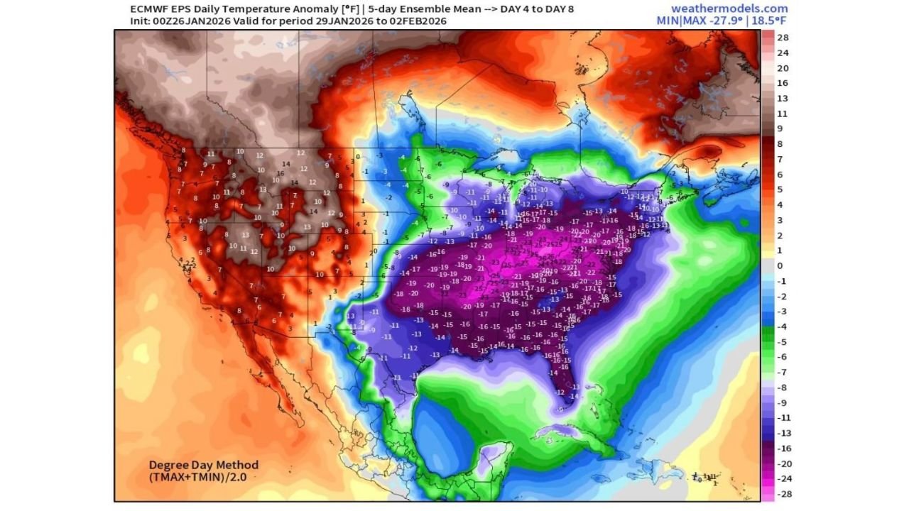
The ECMWF ensemble temperature anomaly maps show a widespread and intense cold outbreak, with temperatures running 15 to 25 degrees below normal across much of the South, and even colder anomalies farther north. This Arctic air intrusion is expected to settle in beginning Saturday and persist into early next week.
Freeze Threat Extends to the Gulf Coast and South Florida
Forecast data indicates lows plunging into the teens along portions of the northern Gulf Coast, with single-digit temperatures possible inland across parts of the Deep South. Even areas typically insulated from hard freezes could be affected.
Of particular concern:
- Texas, Louisiana, Mississippi, and Alabama may see multiple nights of hard freezes
- Georgia and northern Florida face widespread sub-freezing temperatures
- South Florida shows a real risk of overnight freezes reaching far south
This is a classic pipe-busting setup, where prolonged cold rather than just brief dips below freezing creates infrastructure and agricultural risks.
Florida Citrus Industry Urged to Prepare
The forecast explicitly highlights Florida citrus growers, who are being urged to prepare for multiple consecutive nights below freezing, starting Saturday and continuing into early next week.
This type of extended freeze — not just a single cold night — is what poses the greatest threat to citrus crops, irrigation systems, and exposed plumbing.
Winter Storm Risk Shifts North of the Deep South
While the South faces extreme cold, forecasters note that significant winter storm potential appears limited across the southern states themselves.
Instead, the strongest winter storm threat may shift northward into:
- The Carolinas
- The Mid-Atlantic
- The Northeast
In these regions, the same Arctic air mass interacting with storm systems could lead to major winter weather impacts, potentially including blizzard conditions if storm tracks align.
Why This Cold Outbreak Stands Out
The anomaly maps show a deep purple and blue core centered over the central and eastern United States, signaling one of the strongest cold departures of the season. This is not a marginal cold snap — it is a deep Arctic intrusion with national-scale impacts.
Key factors making this event notable:
- Unusually cold air penetrating far south
- Duration lasting several days, not hours
- Freeze potential in regions that rarely experience it
What to Watch Next
- Cold arrival begins Saturday
- Coldest nights likely Saturday through early next week
- Any changes in cloud cover or wind could locally influence how severe overnight lows become
Stay with WaldronNews.com for continued updates as this Arctic outbreak unfolds. We’ll track freeze warnings, agricultural impacts, and whether record-challenging cold materializes across the South and Gulf Coast.