
Multiday Severe Weather Outbreak Reaches Crescendo Monday With Monstrous Hail, Strong Tornadoes and 90 mph Wind Gusts Threatening Tens of Millions From Springfield to Chicago
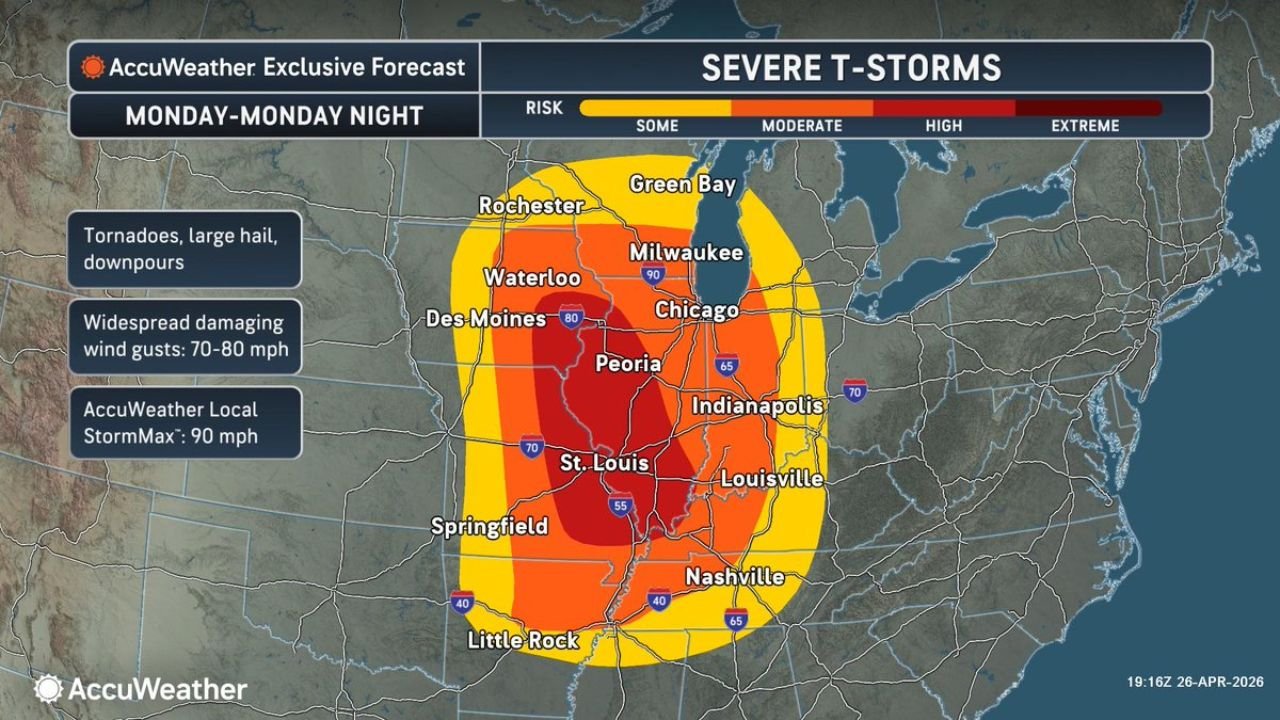
SPRINGFIELD, Illinois — A multiday severe weather outbreak is reaching its most dangerous moment Monday, and the numbers attached to this event are not routine. Monstrous hail, strong tornadoes and destructive winds will threaten tens of millions of people across the Midwest and Mid-South as the system peaks Monday afternoon through Monday night. Widespread damaging wind gusts of 70 to 80 mph are expected across the core risk zone, with a StormMax of 90 mph in the most intense storm segments. The highest tornado risk is pinned directly over a corridor running from Davenport and Quincy through Springfield and St. Louis.
The Tornado Threat — Davenport to St. Louis Is the Bullseye
The tornado forecast for Monday afternoon through Monday night places the highest tornado risk inside a defined red zone covering western and central Illinois into eastern Missouri. The corridor stretches from Davenport in the north through Quincy and Springfield and down into St. Louis, with two specific hazards flagged for everyone inside this zone:
- Strong, long-track tornadoes — not brief touchdowns but sustained tornadoes that stay on the ground for extended distances, crossing multiple counties and affecting large numbers of communities in a single continuous path
- Visibility obscured by rain and darkness — a critically dangerous compounding factor. Tornadoes occurring at night or inside heavy rain are invisible to the naked eye. There is no visual warning. The only reliable alert is a tornado warning on a weather device, which is why having multiple alert sources active before storms arrive is not optional for anyone in this corridor
The geography of central Illinois amplifies the long-track tornado risk. Flat terrain from Quincy through Springfield and into the St. Louis metro offers no natural barriers to slow or redirect a tornado once it forms.
The Severe Thunderstorm Threat — Extreme Risk at the Core
The severe thunderstorm outlook for Monday through Monday night shows a risk gradient that spans from Some to Extreme across the region:
- Extreme risk — the highest category, centered over Springfield, Illinois and the surrounding corridor into St. Louis, Missouri
- High risk — covering Peoria, Illinois, Indianapolis, Indiana, Louisville, Kentucky and extending into Nashville, Tennessee
- Moderate risk — reaching Chicago, Illinois, Milwaukee, Wisconsin, Des Moines, Iowa and Waterloo, Iowa
- Some risk — the outer boundary touching Rochester, Minnesota, Green Bay, Wisconsin and Little Rock, Arkansas
The threats driving these risk levels:
- Tornadoes across the full risk zone
- Large hail — monstrous hail specifically called out, meaning stones capable of significant property damage to vehicles, roofs and structures
- Downpours — heavy rainfall rates embedded in the severe storm complex
- Widespread damaging wind gusts of 70 to 80 mph across the core zone
- StormMax of 90 mph — the peak gust estimate in the most intense individual storm segments, a threshold that causes structural damage to well-built homes and snaps large trees
Why 90 mph Winds Are a Structural Threat
A 90 mph wind gust sits in the same damage category as a weak to moderate tornado. At that speed:
- Large, mature trees snap or uproot entirely
- Roofs on homes and commercial buildings suffer structural damage
- Unsecured outbuildings and structures fail
- Power infrastructure across a wide corridor goes down simultaneously, producing outages that can last days in the hardest-hit areas
- Debris becomes a lethal projectile hazard across the full path of the storm line
The difference between a tornado and a 90 mph straight-line wind event is geography — a tornado carves a narrow path while straight-line winds affect every structure across the full width of the storm line simultaneously.
Cities Inside Each Risk Zone
Extreme severe thunderstorm risk:
- Springfield, Illinois
- Quincy, Illinois
- St. Louis, Missouri
High severe thunderstorm risk:
- Peoria, Illinois
- Davenport, Iowa
- Indianapolis, Indiana
- Louisville, Kentucky
- Nashville, Tennessee
Moderate severe thunderstorm risk:
- Chicago, Illinois
- Milwaukee, Wisconsin
- Des Moines, Iowa
- Waterloo, Iowa
- Evansville, Indiana
Highest tornado risk zone specifically:
- Davenport, Iowa
- Quincy, Illinois
- Springfield, Illinois
- St. Louis, Missouri
The Darkness and Rain Visibility Problem
The tornado threat extending through Monday night introduces one of the most dangerous variables in severe weather — tornadoes that cannot be seen. Nighttime tornadoes kill at significantly higher rates than daytime tornadoes because people have no visual confirmation of what is approaching. Rain-wrapped tornadoes compound this further, making a large, violent tornado invisible even in daylight. The forecast explicitly flags visibility obscured by rain and darkness as a hazard for Monday’s event.
This means:
- Do not rely on seeing the tornado to decide when to shelter — by the time a nighttime or rain-wrapped tornado is visible, it may be too late to reach shelter safely
- Shelter immediately when a tornado warning is issued for your county — the warning is the signal to act, not visual confirmation
- Keep NOAA weather radio running through Monday night — phone alerts can be delayed or missed during sleep
What to Do Before Monday Afternoon
- Finalize shelter plans now — basement or lowest-floor interior room away from all windows for everyone in the household
- Charge all devices — phones, weather radios, flashlights and power banks should be at full charge before the first storms arrive
- Secure all outdoor objects — 70 to 90 mph winds will turn anything unsecured into a dangerous projectile
- Mobile home residents across the Springfield-Quincy-St. Louis corridor must be in a permanent structure before Monday afternoon — this is a life-safety requirement, not a suggestion
- Do not drive into storms — storm chasers and emergency personnel will be operating in this environment; everyone else should be sheltered in place
WaldronNews.com will continue tracking Monday’s severe weather outbreak across Illinois, Missouri and the broader Midwest and provide real-time updates on tornado warnings, wind damage reports and storm progression through Monday night.