
Nocturnal Tornado Threat Tonight Resembles Historic Violent Outbreak Environments as Surface CAPE Exceeds 4000 J/kg and Hodographs Signal Strong to Violent Deviant Tornadoes
SPRINGFIELD, Illinois — The atmospheric setup taking shape for tonight carries a conditional but hard-to-ignore signal for an isolated yet significant nocturnal tornado event. The environment assembling across the central Midwest tonight — characterized by extreme surface-based CAPE values and hodograph shapes that forecasters are comparing directly to past violent tornado events — resembles the setups that produced families of strong to violent deviant tornadoes in events like Plevna, Greensburg, Geary and Mulhall. These are not obscure references. They are among the most destructive single-supercell tornado outbreaks in Plains and Midwest history.
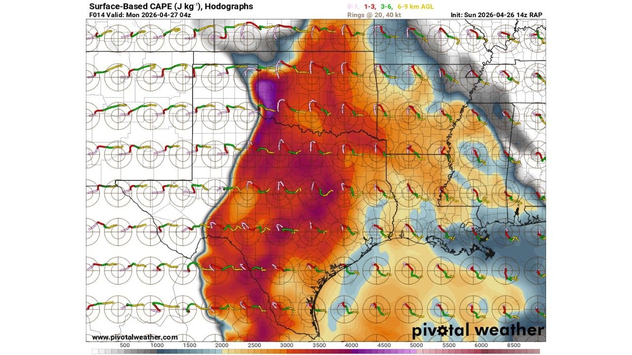
What the Surface CAPE and Hodograph Map Shows
The Surface-Based CAPE and Hodograph analysis valid Monday April 27 at 04Z — early Monday morning local time — from the RAP model initialized Sunday April 26 at 14Z shows one of the more striking instability footprints seen in a spring severe weather setup across this region.
CAPE — Convective Available Potential Energy — measures the fuel available in the atmosphere for thunderstorm development. The color scale on this map runs from 500 to 8500 joules per kilogram, and the purple shading visible across the core of the risk zone indicates values exceeding 4000 J/kg in the highest areas, with the deep red and orange extending through a broad corridor covering Illinois, Missouri, Indiana and Kentucky at 3000 to 4500 J/kg.
To put those numbers in context:
- 1000-1500 J/kg — sufficient for organized severe thunderstorms
- 2000-2500 J/kg — significant instability, strong storm environment
- 3000+ J/kg — extreme instability, major severe weather environment
- 4000+ J/kg — the purple zone on this map — rare, violent storm potential
What the Hodographs Are Saying
The hodographs plotted across the map — the curved shapes at each grid point showing how wind speed and direction change with height — are the second critical element of this forecast. A hodograph is a meteorologist’s tool for measuring wind shear, the ingredient that allows thunderstorms to rotate and produce tornadoes.
The hodograph shapes visible across the Illinois and Missouri corridor show:
- Large, curved hodographs indicating strong deep-layer shear — the total wind change from the surface to jet stream level — sufficient to sustain long-lived, organized supercells
- Significant low-level curvature in the 0-1 km layer (pink portion of the hodograph) indicating strong streamwise vorticity — the rotational energy available to be tilted into a supercell updraft and produce a powerful mesocyclone
- Hodograph lengths extending past the 40-knot ring in the core zone — a threshold associated with environments capable of producing significant, long-tracked tornadoes
The combination of extreme CAPE and large, curved hodographs is exactly what characterized the atmospheric environments before the historical tornado events referenced in the forecast — Plevna, Greensburg, Geary and Mulhall.
Why Deviant Tornadoes Are the Specific Concern
The forecast specifically references deviant tornadoes — a term that carries precise meteorological meaning. In a standard supercell environment, storms move in a direction somewhat to the right of the mean wind. Deviant right-moving supercells move even further to the right, often tracking in unexpected directions that catch communities and emergency managers off guard.
Deviant movers are dangerous for three reasons:
- They move perpendicular to the mean flow, making their track difficult to anticipate from standard radar interpretation
- They tend to be longer-lived because their unusual track keeps them in the most unstable portion of the warm sector for extended periods
- They produce families of tornadoes — multiple tornadoes from the same storm as the mesocyclone cycles repeatedly — rather than single brief touchdowns
The historical events named in the forecast are precisely the type of single-supercell, long-duration, multi-tornado events that deviant movers produce. A single supercell in the Greensburg event carved a path 1.7 miles wide across Kansas.
The Nocturnal Dimension — Why Tonight Specifically Is Dangerous
The nocturnal qualifier in this forecast is not incidental. Overnight tornado events kill at significantly higher rates than daytime events for a set of compounding reasons:
- No visual detection — tornadoes at night are invisible without lightning illumination
- Rain-wrapping — supercells in high-CAPE environments frequently wrap themselves in heavy precipitation, hiding the tornado from radar interpretation and from any outdoor observers
- Alert response time — residents asleep when warnings are issued have minutes to reach shelter after being woken by an alert, assuming the alert wakes them at all
- Reduced situational awareness — nighttime conditions eliminate the ability to monitor storm approach visually, making electronic warning systems the only defense
Who Needs to Act Right Now
Given the CAPE values exceeding 4000 J/kg and the hodograph signal for deviant supercell development, every resident across the following areas should treat tonight as a confirmed high-end threat:
- Springfield, Illinois and the central Illinois corridor
- Peoria and Bloomington, Illinois
- Quincy, Illinois
- St. Louis, Missouri and the surrounding metro
- Evansville, Indiana
- Paducah, Kentucky
- Cape Girardeau, Missouri
What to Do Before Going to Sleep Tonight
- Do not go to sleep without a working overnight alert system — NOAA weather radio set to alarm, phone emergency alerts confirmed active and volume at maximum
- Physically walk to your shelter location before bedtime — basement stairs in the dark during a tornado warning are a hazard by themselves
- Mobile home residents must be in a permanent structure tonight — the CAPE and shear values in this environment produce tornadoes capable of complete destruction of manufactured housing
- If you wake to a tornado warning, move immediately — do not look outside, do not gather belongings, do not hesitate
- Families with children or elderly residents should establish a shelter plan that accounts for carrying or assisting those who cannot move quickly on their own
WaldronNews.com will continue tracking tonight’s nocturnal tornado threat across Illinois, Missouri and the broader Midwest and provide immediate updates on supercell development, tornado warnings and storm reports through the overnight hours.