
Severe Thunderstorm Threat Expands From Texas to the Ohio Valley Today as Storm System Targets Oklahoma, Arkansas, Missouri and Illinois With Hail and Damaging Winds
UNITED STATES — The first round of a multi-day severe weather pattern is expected to unfold today across the central and southern United States, where meteorologists say a developing storm system could trigger widespread thunderstorms from the southern Plains to the Ohio Valley.
According to the latest severe weather outlook, storms are likely to form along a frontal boundary stretching from the Ohio Valley southward into the southern Plains, creating a corridor where severe thunderstorms could develop during the day and evening hours.
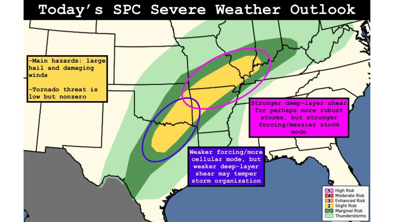
The primary hazards across the region are expected to be large hail and damaging wind gusts, while the tornado threat remains low but not zero.
Slight Risk Area Covers Several Central U.S. States
The Storm Prediction Center (SPC) has issued a Slight Risk (Level 2 of 5) for severe storms across a large area extending from Texas and Oklahoma through Arkansas and Missouri into parts of Illinois and Kentucky.
States most likely to see stronger thunderstorms include:
- Oklahoma
- Texas
- Arkansas
- Missouri
- Illinois
- Kentucky
- Portions of the Ohio Valley
A broader marginal thunderstorm risk zone surrounds this area, meaning scattered storms could occur across much of the central United States.
Storms Expected to Develop Along Frontal Boundary
Meteorologists say storms will likely develop as a shortwave trough moves across the region, providing the lift needed to trigger thunderstorm development.
This upper-level disturbance interacting with the frontal boundary is expected to produce clusters of storms across the central Plains and Mid-Mississippi Valley, gradually moving eastward through the day.
The exact structure of the storms may vary depending on atmospheric conditions in different parts of the risk zone.
Northern Areas Could See Stronger Storm Organization
Forecast data suggests northern sections of the risk area, particularly across Missouri, Illinois, and nearby regions, could experience stronger storm organization.
This is due to stronger deep-layer wind shear, which helps thunderstorms organize and maintain strength. However, stronger atmospheric forcing in this region may also result in messier storm structures, meaning storms could merge into clusters or lines.
Even so, these conditions still support the potential for robust storms capable of producing severe weather.
Southern Plains May See More Isolated Storms
Farther south across Texas and southern Oklahoma, meteorologists expect storms to develop in a more cellular or isolated pattern.
In these areas, weaker wind shear may limit storm organization, but individual thunderstorms could still produce large hail or localized damaging winds.
The overall storm coverage may be more scattered compared to areas farther north.
Main Threats: Large Hail and Damaging Winds
Across the entire risk region, the most likely severe weather hazards include:
- Large hail
- Damaging wind gusts
- Heavy rainfall
While the tornado risk is not the primary concern, forecasters say a brief tornado cannot be ruled out if a storm becomes organized enough to rotate.
Start of a Multi-Day Severe Weather Pattern
Today’s storms are expected to mark the beginning of several days of severe weather potential across the central and southern United States.
Meteorologists are closely monitoring how the atmosphere evolves as additional storm systems move across the country in the coming days.
WaldronNews Monitoring Developing Severe Weather
Residents across Texas, Oklahoma, Arkansas, Missouri, Illinois, and the Ohio Valley should stay aware of weather updates as storms begin developing later today.
WaldronNews will continue tracking severe weather conditions, storm timing, and potential impacts as this active weather pattern unfolds across the United States.
For continued updates, forecasts, and safety information, follow the latest coverage on WaldronNews.com.