
University of Oklahoma Research Maps Hurricane Landfall Return Periods for Every Coastal County From Texas to Maine
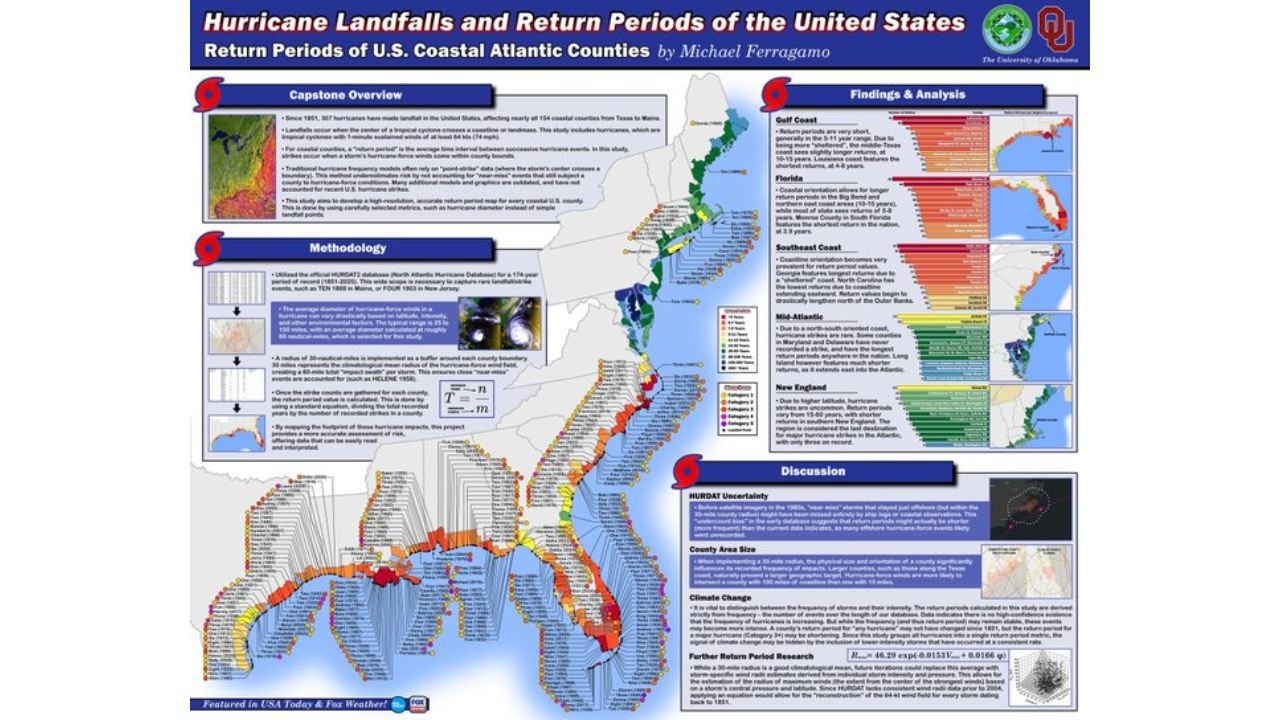
NORMAN, Oklahoma — A University of Oklahoma capstone research project is drawing widespread attention after being featured in USA Today and Fox Weather, and for good reason. The study by researcher Michael Ferragamo maps hurricane landfall return periods for all 154 coastal counties from Texas to Maine, using the official HURDAT2 database covering 174 years of Atlantic hurricane history from 1851 through 2025. The result is one of the most detailed county-level hurricane frequency maps ever produced for the United States coastline, and the findings reveal striking differences in risk depending on where along the coast a community sits.
What the Research Actually Measured and How
Understanding the findings requires understanding what a return period means in practical terms.
| Term | Plain Language Explanation |
|---|---|
| Return period | The average number of years between successive hurricane events at a given location. A 50-year return period means a hurricane impacts that county roughly once every 50 years on average. |
| Landfall definition | A tropical cyclone with 1-minute sustained winds of at least 64 knots (74 mph) reaching a county |
| Near-miss events | The study accounts for storms that passed close to a county but did not make direct landfall, using a 30-nautical-mile buffer impact swath |
| 174-year record | The HURDAT2 database from 1851 through 2025, covering 307 total hurricane landfalls across 154 counties |
| Hurricane-force winds | Averaged 60 nautical miles wide, which is the impact swath used in the methodology |
The key methodological innovation is that the study does not rely on simple point-estimates that only count storms making direct landfall. By using a 30-nautical-mile buffer around each county boundary, the research captures near-miss events that still subjected a county to hurricane-force conditions, producing a more accurate risk picture than earlier models.
What the Findings Show Region by Region
The research divides the Atlantic coast into distinct regions and the differences in return periods between them are dramatic.
| Region | Key Finding | Shortest Return Period |
|---|---|---|
| Gulf Coast | Return periods are very short. Texas coast sees the longest Gulf returns due to orientation. Louisiana coast features the shortest in the nation. | Louisiana coast, some counties at 3.9 years |
| Florida | Coastal orientation allows longer return periods in some areas while most of the state sees 5 to 8 year returns. Monroe County in South Florida features the shortest in Florida at 3.9 years. | Monroe County, 3.9 years |
| Southeast Coast | Coastline orientation becomes very important. North Carolina has the longest returns in the Southeast due to the drastically northward jog of the Outer Banks. | Highly variable by county |
| Mid-Atlantic | Northeast-oriented coast means fewer direct strikes. Some counties in Maryland and Delaware have among the longest return periods anywhere in the nation. Long Island in New York is an exception, funneling more storms into the Atlantic coast. | Some of the longest in the nation |
| New England | Higher latitude means fewer storms. Return periods vary from 15 to 90 years with shorter periods in southern New England. The region is considered the last destination for major hurricane strikes in the Atlantic basin. | 15 to 90 years range |
The Most Striking Specific Findings From the Data
| Finding | Detail |
|---|---|
| Shortest return period in the nation | Louisiana coast, some counties at approximately 3.9 years |
| Shortest return period in Florida | Monroe County in South Florida at 3.9 years |
| Longest return period in the Southeast | North Carolina counties along the Outer Banks due to coastal geometry |
| Most hurricane landfalls total | Gulf Coast and Florida dominate the 307 total landfalls since 1851 |
| New England range | 15 to 90 years depending on location within the region |
| Average hurricane-force wind swath | 60 nautical miles, used as the standard impact radius in the study |
Why Coastal Orientation Changes Everything About Hurricane Risk
One of the most important insights from the research is how much the direction a coastline faces determines how often hurricanes strike it. This is not obvious from looking at a standard map.
The Gulf Coast faces south and southwest, directly into the path of storms that develop in the Gulf of Mexico and the western Caribbean. Storms tracking northward have no geographic barrier before reaching these coasts, which is why Louisiana produces the shortest return periods in the nation.
Florida’s orientation is complex. The peninsula faces multiple directions depending on location, and the southern tip at Monroe County catches storms from multiple approach angles, explaining its extremely short return period.
North Carolina’s Outer Banks jut dramatically eastward into the Atlantic compared to the rest of the Southeast coast. This geometry means most storms tracking northward along the coast pass just east of the Banks without making direct landfall, producing longer return periods than the surrounding Southeast region would suggest.
The Mid-Atlantic and New England coasts face primarily northeast, meaning storms must recurve significantly and often lose intensity before reaching these latitudes, producing the nation’s longest return periods.
What the Research Means for Coastal Residents
- Residents of Louisiana and Monroe County, Florida live in the two areas with the shortest hurricane return periods in the nation. A roughly 4-year average return period means these communities face major hurricane threats multiple times per decade, not once per generation.
- Mid-Atlantic residents from Maryland through Delaware and into New Jersey live in counties with some of the longest return periods in the nation, but that does not mean zero risk. Long return periods mean infrequent events, not impossible ones, and storm surge from even a weakened hurricane reaching these latitudes can cause catastrophic damage.
- North Carolina Outer Banks communities should not be lulled by longer return periods compared to their Southeast neighbors. The research specifically notes that coastal geometry explains the longer periods, not an absence of storm intensity when landfalls do occur.
- The climate change section of the research notes that the relationship between storm frequency and intensity suggests return periods may be shortening as high-intensity storms become more common, meaning historical return periods could underestimate future risk for many counties.
WaldronNews.com will continue tracking hurricane season research and preparedness information as the 2026 Atlantic hurricane season approaches and provide updates on storm development throughout the season.