
Tuesday May 5 Offers the Best Weather Day of the Week East of the Appalachians Before Cold Front Arrives Late
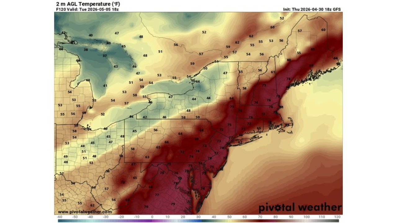
NEW YORK, New York — After several days of chilliness and rain across the Northeast and Mid-Atlantic, Tuesday May 5 stands out as the one genuinely pleasant day in the next five for communities east of the Appalachian Mountains. The setup relies entirely on timing. A cold front will eventually push through the region Tuesday, but if it holds off until later in the afternoon as forecast, the hours before its arrival deliver warm temperatures and a welcome break from the unsettled pattern that has dominated the region. The temperature map valid Tuesday afternoon tells the story dramatically, with 70s and even low 80s pushing into the Mid-Atlantic and Southeast while the interior Northeast stays cooler in the 50s and 60s.
Temperature Forecast for Tuesday May 5 Across the East
The contrast between the warm air east of the Appalachians and the cold air still locked in over the Great Lakes and interior Northeast is one of the most striking features of the Tuesday setup.
| City | Region | Tuesday Afternoon Temperature |
|---|---|---|
| Washington D.C. area | Mid-Atlantic | 75 to 78 degrees |
| Philadelphia, Pennsylvania | Mid-Atlantic | 75 to 78 degrees |
| New York City | Northeast coast | 75 to 78 degrees |
| Boston, Massachusetts | New England coast | 60 to 62 degrees |
| Hartford, Connecticut | Southern New England | 61 to 64 degrees |
| Albany, New York | Upstate New York | 47 to 56 degrees |
| Buffalo, New York | Western New York | 42 to 46 degrees |
| Pittsburgh, Pennsylvania | Western Pennsylvania | 58 degrees |
| Charlotte, North Carolina | Southeast | 73 to 75 degrees |
| Raleigh, North Carolina | Southeast | 75 to 76 degrees |
| Richmond, Virginia | Mid-Atlantic | 76 to 78 degrees |
| Atlanta, Georgia | Deep South | 77 to 80 degrees |
The warmest air sits across the Mid-Atlantic corridor from Washington D.C. through Philadelphia and into coastal New York, where temperatures reach the mid to upper 70s. Further inland and northward, the cold air mass still controlling the Great Lakes keeps Buffalo at 42 to 46 degrees and Albany in the upper 40s to mid 50s even on the best day of the week.
Why Tuesday Works and Why the Timing Is Everything
The entire pleasant day scenario for the coast depends on one atmospheric sequence working correctly.
| Factor | What Needs to Happen |
|---|---|
| Cold front position | Must hold west of the Appalachians through the morning and midday hours |
| Warm air ahead of the front | Builds quickly Tuesday morning across the Mid-Atlantic and coastal Northeast |
| Front arrival timing | Late afternoon or evening east of the mountains |
| Window of nice weather | Roughly late morning through mid afternoon for most coastal cities |
If the front arrives even a few hours earlier than forecast, the pleasant window shrinks significantly or disappears entirely for cities further north. Washington D.C., Philadelphia, and New York City all benefit most from the delayed frontal timing because the warm southerly flow ahead of the front has more time to establish before the cold air pushes in.
🌧️ What the Precipitation Forecast Shows for Tuesday
The precipitation map valid Tuesday afternoon shows scattered green returns across the region but the key detail is the placement and intensity of any rain.
| Area | Precipitation Signal Tuesday |
|---|---|
| Western Pennsylvania and New York | Light to moderate green returns, early frontal activity |
| Central New York | Yellow returns indicating locally heavier showers along the frontal boundary |
| Coastal Mid-Atlantic | Mostly dry during the warm afternoon window |
| New England coast | Largely dry through midday, potential for late day showers |
| Southeast | Mostly dry and warm, well ahead of the front |
The yellow returns concentrated over central New York indicate the frontal boundary and its associated heavier showers sitting well inland during the afternoon hours. Cities along the coast from Washington D.C. through New York sit ahead of that boundary during the prime afternoon window, which is precisely why Tuesday works as a pleasant day for the coastal corridor specifically.
What Each Region Should Know About Tuesday
Mid-Atlantic residents from Washington D.C. through Philadelphia into New Jersey have the best setup of anyone east of the Appalachians. Temperatures in the mid to upper 70s with the front still west of the mountains through most of the day means a genuine warm spring afternoon is possible before showers arrive late.
New York City sits at the edge of the warm zone. Temperatures reaching the mid to upper 70s are possible if the front holds off as forecast, but the city is close enough to the frontal boundary that an earlier-than-expected push could clip the area with showers before the warmest temperatures arrive.
Boston and southern New England stay cooler at 60 to 64 degrees even on the best day of the week. The cold air mass over the interior Northeast keeps warm air from fully reaching this latitude even ahead of the front.
Upstate New York and western Pennsylvania sit on the wrong side of the temperature gradient. Buffalo at 42 to 46 degrees and Albany in the upper 40s are well inside the cold air mass and will not experience any of the warmth building along the coast Tuesday afternoon.
Southeast and Mid-Atlantic inland communities from Charlotte through Raleigh and Richmond reach the warmest temperatures of all at 73 to 80 degrees, sitting furthest ahead of the approaching cold front.
What to Watch Before Tuesday Arrives
- Whether the cold front holds off until late afternoon east of the Appalachians as currently forecast. Even a 3 to 4 hour earlier arrival significantly shortens the pleasant window for coastal cities.
- Wednesday and beyond look unsettled again as the cold front pushes through and cooler air returns behind it, making Tuesday the clear outlier in an otherwise cool and rainy week.
- Albany and Buffalo residents should not plan outdoor activities based on Tuesday being the best day. The temperature gradient means the pleasant break is almost entirely a coastal and Mid-Atlantic story, not an interior Northeast story.
- Any shower or thunderstorm development along the frontal boundary Tuesday afternoon that could push eastward into the coastal cities earlier than the late-day timing currently suggests.
WaldronNews.com will continue tracking Tuesday’s weather window across the Northeast and Mid-Atlantic and provide updates as the cold front timing becomes clearer heading into the weekend.