
Central, East and Southeast Texas Face Significant River Flooding Risk Through Early Saturday as Two Rounds of Heavy Rain Target the State
AUSTIN, Texas — Heavy rainfall is pushing through Texas in two distinct rounds, and the combination is raising serious river flooding concerns from Central Texas through East and Southeast Texas through early Saturday morning. The first round targeting the Edwards Plateau and Hill Country on Thursday is giving way to a second round hitting Central to East and Southeast Texas on Friday, and the back-to-back rainfall on already-stressed streamflows creates conditions where moderate to significant river flooding cannot be ruled out across the most vulnerable corridors.
Two Rounds of Rain — Where Each One Hits and When
| Round | Timing | Primary Area | Concern Level |
|---|---|---|---|
| Round 1 | Thursday | Edwards Plateau and Hill Country | Minor river flooding expected |
| Round 2 | Friday | Central to East and Southeast Texas | Moderate to significant flooding possible |
The two-round structure is what makes this event more dangerous than a single rainfall episode. Round 1 saturates soils and raises streamflows across the Hill Country and Edwards Plateau. When Round 2 arrives Friday across Central and East Texas, the ground has less capacity to absorb additional rainfall and rivers that are already running elevated respond much more quickly to new rainfall.
River Flooding Impact Levels and What Each One Means
| Impact Level | What Happens on the Ground |
|---|---|
| Minor | Low water crossings at risk, agricultural and livestock fields at risk |
| Moderate | Secondary and rural roads flooded, agricultural and livestock fields flooded, isolated structures threatened |
| Major | Widespread damage to primary roads and highways, significant number of structures impacted, communities cut off |
Current streamflows across Texas range from low to normal heading into this event, which provides some buffer. However the USGS 48-hour forecast rainfall map shows substantial accumulations across Central and East Texas that are capable of pushing rivers from those low starting levels into minor and moderate flood categories by Saturday morning. The most significant concern is that moderate river flooding cannot be ruled out specifically from Central to East and Southeast Texas, with some rivers potentially reaching major flood stage depending on exactly where the heaviest totals fall.
Areas of Greatest Concern Across Texas
| Region | Flood Risk | Round Affecting This Area |
|---|---|---|
| Edwards Plateau and Hill Country | Minor flooding likely | Round 1 Thursday |
| Central Texas | Moderate flooding possible | Round 2 Friday |
| East Texas | Moderate to significant flooding possible | Round 2 Friday |
| Southeast Texas | Significant flooding cannot be ruled out | Round 2 Friday |
| Low water crossings statewide | At risk beginning Thursday | Both rounds |
Southeast Texas carries the highest concern language in the forecast. The combination of flat terrain, rivers that drain large upstream watersheds, and the potential for heavy Round 2 rainfall creates a scenario where flood impacts could be more widespread and longer-lasting than a single-day event would produce.
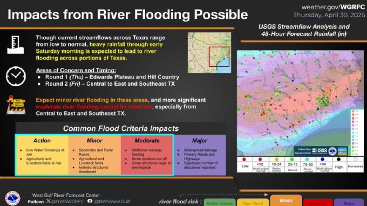
What the USGS Streamflow Map Reveals
The rainfall forecast map shows the 48-hour precipitation accumulation across Texas with the deepest purple and red values indicating the heaviest totals concentrated across Central and East Texas. The color gradient confirms that the eastern half of the state is absorbing the most rainfall across the two-round event, which aligns directly with the river flooding concern areas identified by the West Gulf River Forecast Center.
Low water crossings are particularly dangerous during rising river events because they can go from passable to impassable within minutes during rapid rises, and the water depth across the road surface is almost impossible to judge accurately from a vehicle. A vehicle swept off a low water crossing in moving water is one of the most common causes of flood-related fatalities in Texas.
What Texas Residents Must Do Before Friday’s Round 2 Arrives
- Never drive across a flooded low water crossing regardless of how shallow the water appears. Turn around, do not drown is not just a slogan. Moving water at ankle depth exerts enough force to knock a person down and knee-deep water can sweep a vehicle off a crossing.
- East and Southeast Texas residents face the greatest flood risk across the two-round event. Anyone living near rivers, creeks, or streams in this corridor should monitor water levels closely Thursday night and through Friday.
- Hill Country residents should expect Round 1 to raise creek and river levels Thursday. Even if Round 1 totals seem manageable, the saturated soils will amplify Round 2 impacts on Friday significantly.
- Agricultural and livestock operations across Central and East Texas should move livestock out of low-lying fields before Friday’s Round 2 arrives. Minor flooding that begins as a field nuisance can become a livestock emergency quickly during rising river events.
- Watch for river forecast updates from the West Gulf River Forecast Center through Friday. The difference between a river reaching minor versus moderate flood stage can shift rapidly as rainfall totals become clearer.
WaldronNews.com will continue tracking Texas river flooding risk through Saturday morning and provide updates as river gauges rise and flood warnings are issued across Central, East, and Southeast Texas.