
Powerful Jet Stream Over Texas and Oklahoma Signals Major Severe Weather Threat Friday as Forecasters Maintain 30% Risk Across the Central U.S.
UNITED STATES — Meteorologists are closely monitoring a powerful storm system developing over the central United States, where atmospheric conditions are aligning for a potentially significant severe weather outbreak on Friday, March 6.
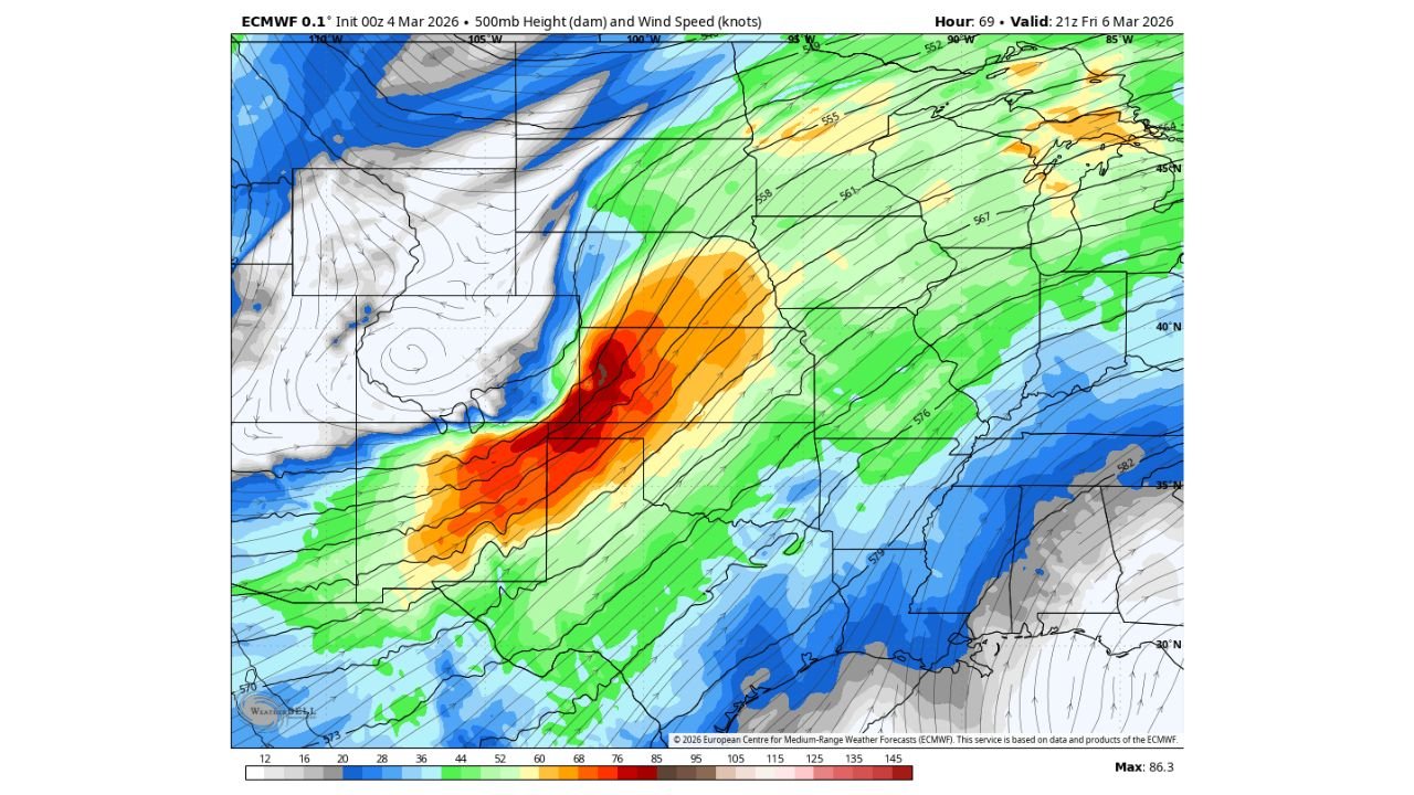
Forecast guidance shows an intense upper-level jet stream sweeping from Texas and Oklahoma northeast into Missouri, Illinois, and the Midwest, creating an environment favorable for severe thunderstorms. Because of this setup, forecasters continue to support a 30% severe weather probability across parts of the central United States, indicating a strong potential for organized severe storms.
Powerful Upper-Level Winds Driving the Setup
Weather models from the European ECMWF forecasting system show a strong mid-level jet stream intensifying across the Southern Plains, particularly over:
- North Texas
- Oklahoma
- Kansas
- Missouri
Wind speeds at roughly 500 millibars in the atmosphere are forecast to increase dramatically as the storm system strengthens and moves eastward. These strong winds aloft play a key role in organizing thunderstorms and allowing them to rotate, which can lead to supercell storms capable of producing severe weather.
The jet stream is expected to extend northeast toward Illinois, Wisconsin, and the Great Lakes, spreading the severe weather potential across a broad region.
Storm System Emerging From the Western United States
The severe weather threat is tied to a large upper-level storm system currently moving inland across the western United States.
As this system advances into the Plains, it is expected to strengthen the jet stream over the central states while drawing warm, humid air northward from the Gulf of Mexico.
This collision of warm moisture near the surface and powerful winds in the upper atmosphere is one of the classic patterns that leads to widespread severe thunderstorms across the Plains and Midwest.
Severe Weather Corridor Could Stretch Across Multiple States
If current model trends hold, severe storms could develop across a corridor including parts of:
- Texas
- Oklahoma
- Kansas
- Missouri
- Arkansas
- Illinois
- Iowa
- Portions of the Midwest and Great Lakes
Meteorologists note that this type of large-scale atmospheric pattern can support multiple rounds of severe storms, potentially affecting millions of residents across the central United States.
Why a 30% Risk Is Significant
The 30% severe weather probability issued for parts of the region indicates a relatively high chance that severe storms will develop within 25 miles of a given location.
In meteorological terms, a 30% probability area often signals a well-organized synoptic-scale setup, meaning the large-scale atmospheric environment is favorable for significant severe weather.
While exact storm locations and intensity will become clearer closer to Friday, forecasters say there is strong justification for maintaining this elevated risk level given the strength of the developing system.
Forecast Adjustments Still Possible
Although the atmospheric signals are strong, meteorologists emphasize that small changes in storm timing, moisture levels, or storm track could shift the highest risk areas.
New model data over the next 24 to 48 hours will help refine the forecast and determine exactly where the most intense storms may develop.
WaldronNews Monitoring Developing Severe Weather Threat
Residents across the Southern Plains and Midwest should stay alert for weather updates as the storm system continues to evolve.
WaldronNews will continue monitoring forecasts and model trends, providing updates on storm timing, severe weather risks, and safety information as Friday’s potential outbreak approaches.
Stay connected with WaldronNews.com for the latest forecasts and severe weather coverage across the United States.