
Understanding the New Severe Weather “CIG” Scale: What EF2 Tornado, 2-Inch Hail, and 74+ mph Wind Risk Levels Mean for Forecasts
UNITED STATES — As severe weather season ramps up across the country, meteorologists are using more detailed tools to communicate the intensity potential of tornadoes, hail, and damaging winds. One of those tools is the Convective Intensity Guidance (CIG) scale, which helps forecasters describe the maximum expected severity of storms within a risk area.
Recent discussions among meteorologists highlight how the CIG scale differs from traditional severe weather probability forecasts, and why understanding these categories can help people better interpret weather outlooks.
What the CIG Scale Measures
The CIG system focuses on the potential intensity of hazards, not just the probability that severe weather will occur.
Unlike standard outlook percentages — such as a 10% tornado probability or a 30% severe risk — CIG categories describe how strong storms could become if they develop.
The scale is used for three main hazards:
- Tornadoes
- Hail
- Damaging winds
Each hazard has its own intensity levels that indicate the possible maximum strength of storms.
Tornado Intensity Categories Explained
For tornado forecasts, the CIG scale indicates the reasonable upper limit of tornado strength expected within a storm environment.
According to the intensity chart:
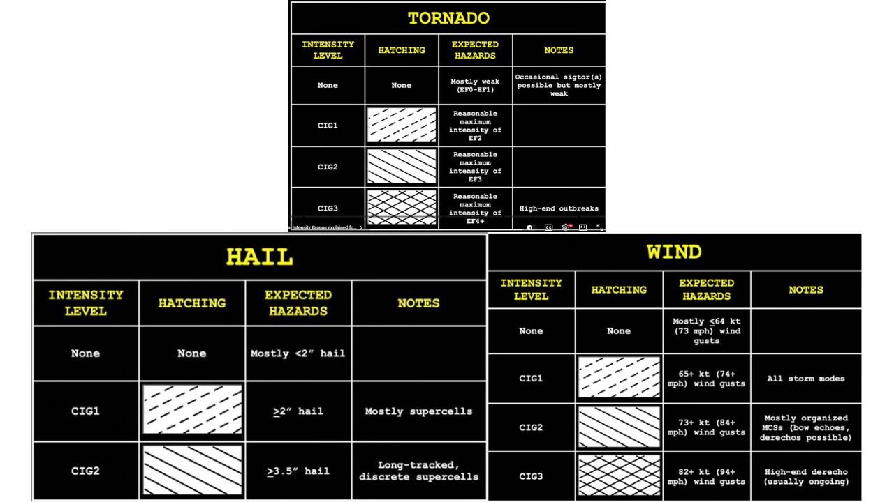
- No CIG level: Mostly weak tornadoes (EF0–EF1), if any occur
- CIG1: Environment capable of producing tornadoes up to EF2 strength
- CIG2: Potential for tornadoes up to EF3 strength
- CIG3: Potential for tornadoes up to EF4 or stronger, typically associated with major outbreaks
Meteorologists emphasize that a CIG1 tornado environment does not automatically mean strong tornadoes will occur, only that atmospheric conditions could support tornadoes up to that intensity.
Hail Intensity Levels
Hail forecasts use a similar system based on hail diameter.
Expected categories include:
- No CIG level: Mostly hail smaller than 2 inches
- CIG1: Hail 2 inches or larger, typically associated with strong supercell storms
- CIG2: Hail 3.5 inches or larger, often linked to long-lived rotating supercells
Large hail events can cause significant damage to vehicles, roofs, crops, and infrastructure.
Wind Damage Potential Categories
Damaging wind events also have intensity levels that indicate how powerful wind gusts could become.
The wind hazard levels include:
- No CIG level: Mostly gusts under 64 knots (73 mph)
- CIG1: Gusts 65 knots (74+ mph) possible in storms
- CIG2: Gusts 73 knots (84+ mph), often associated with organized storm clusters such as bow echoes or derechos
- CIG3: Gusts 82 knots (94+ mph), typically tied to high-end derecho events
These intense wind events can produce widespread power outages and structural damage.
How CIG Differs From Probability-Based Forecasts
Meteorologists often caution that probability forecasts and intensity guidance serve different purposes.
For example:
- A 30% severe weather probability means severe storms could occur within 25 miles of a location.
- A CIG category, however, describes how intense those storms might become if they develop.
Because of this difference, an area can have moderate probabilities but still carry high intensity potential, especially during large-scale storm setups.
Why Understanding Forecast Tools Matters
Severe weather forecasting involves multiple layers of analysis, including atmospheric instability, wind shear, and moisture levels.
Tools like the CIG scale help meteorologists communicate not just the chance of storms, but the possible strength of those storms.
For residents in areas prone to severe weather, understanding these forecast tools can provide valuable context when preparing for potential storms.
WaldronNews Continuing Severe Weather Coverage
As severe weather patterns begin developing across the United States this season, WaldronNews will continue explaining the science behind forecasts while providing timely storm updates and safety information.
Stay connected with WaldronNews.com for the latest severe weather outlooks, storm analysis, and preparedness updates.