
Oklahoma, Kansas, Missouri, and Iowa Face Rising Tornado Threat as Powerful Storm System Targets Plains and Midwest
OKLAHOMA CITY, OKLAHOMA — A rapidly developing storm system across the central United States is raising serious concerns for parts of the Plains and Midwest, where atmospheric conditions suggest a heightened risk of significant tornadoes, including the potential for EF2 or stronger storms, especially across eastern Oklahoma and southeastern Kansas.
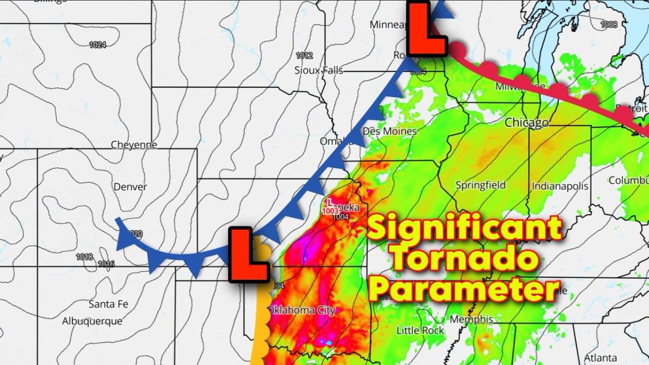
Forecast data analyzing the Significant Tornado Parameter (STP) — a measure used to evaluate the potential strength and organization of tornado-producing storms — highlights a dangerous corridor stretching from central Oklahoma through eastern Oklahoma and into southeastern Kansas, with the risk zone extending northward toward Missouri and Iowa.
The most intense area of concern appears near Oklahoma City, Tulsa, and Topeka, where conditions could become favorable for powerful rotating storms if thunderstorms begin developing ahead of an advancing cold front.
Strong Atmospheric Ingredients Align Across the Plains
The unfolding weather pattern features a low-pressure system moving through the southern Plains, pulling warm and moisture-rich air northward while a strong cold front pushes east across the region.
This setup is creating a narrow but volatile corridor where unstable air, strong wind shear, and rising moisture levels are combining, a classic environment capable of producing severe thunderstorms and tornadoes.
Weather models show particularly high values of the Significant Tornado Parameter across central and eastern Oklahoma into southeast Kansas, indicating an environment where storms could organize into supercells, the type of thunderstorm most associated with strong tornadoes.
If storms remain isolated long enough before merging into a larger line, the risk of longer-lasting tornadoes capable of producing major damage could increase significantly.
Oklahoma and Kansas Could See the Most Intense Storm Activity
Communities within the highest potential risk zone include several major cities and surrounding regions, such as:
- Oklahoma City, Oklahoma
- Tulsa, Oklahoma
- Wichita, Kansas
- Topeka, Kansas
Within this corridor, atmospheric conditions appear supportive of organized rotating thunderstorms capable of producing tornadoes rated EF2 or higher, especially during the period when storm instability and wind shear peak.
These types of tornadoes can cause significant structural damage, down trees and power lines, and create dangerous conditions for anyone caught in their path.
Missouri and Iowa Could Experience Rapid Tornado Spin-Ups
Farther north, including portions of Missouri and Iowa, the storm system is expected to evolve differently as thunderstorms merge into a squall line along the advancing cold front.
While tornadoes in this setup may be shorter-lived, they can still form quickly along the leading edge of the storm line and produce brief but intense damage.
Areas including Kansas City, Missouri, and Des Moines, Iowa, could face damaging wind gusts, heavy rain, isolated tornadoes, and intense thunderstorms as the system pushes northeast through the region.
Storm Development Expected to Progress Through the Day
Forecast trends suggest storms may begin forming across western and central Oklahoma during the afternoon, before strengthening and moving northeast.
The likely progression of the storm system includes:
- Afternoon: Initial storms developing across parts of Oklahoma
- Late Afternoon to Evening: Strong storms potentially intensifying across eastern Oklahoma and southeastern Kansas
- Evening into Night: Storms forming into a squall line moving into Missouri and Iowa
As the system strengthens, conditions could change rapidly across several states, bringing large hail, powerful wind gusts, heavy rainfall, and the possibility of tornadoes.
Severe Weather Threat Could Expand Across Multiple States
Because the storm system is expected to travel northeast, the severe weather risk may extend across a wide portion of the central United States throughout the day and evening.
The combination of warm Gulf moisture, strong upper-level winds, and a sharpening cold front is creating one of the more active severe weather setups seen in recent weeks across the region.
Communities across Oklahoma, Kansas, Missouri, and Iowa are urged to stay aware of weather alerts and monitor local conditions closely as the storm system develops.
Residents Urged to Stay Prepared
Severe weather events can intensify quickly, especially when atmospheric conditions favor strong storm rotation. Residents in areas highlighted within the elevated tornado potential zone should remain alert for watches and warnings as storms begin to form.
Storm shelters, safe rooms, and interior rooms away from windows remain the safest locations during tornado warnings.
Stay tuned to WaldronNews for continuing coverage and updates as this severe weather system develops across the Plains and Midwest.