
Mid-Atlantic States Could See Late-Season Snow Window Around March 16 as Polar Vortex Stretch Brings Colder Air
UNITED STATES — Long-range weather models are beginning to signal a possible shift toward colder conditions across parts of the eastern United States around March 16, raising questions about whether a late-season storm could bring rain or even light snow to portions of the Mid-Atlantic.
While it remains far too early to determine exactly what will happen, early projections suggest that a stretch of the polar vortex later in the month could briefly push colder air into the region, creating a narrow window when winter-like weather could return.
At this point, however, significant uncertainty remains, and forecast guidance continues to change from one model run to the next.
Model Forecasts Show Changing Storm Scenarios
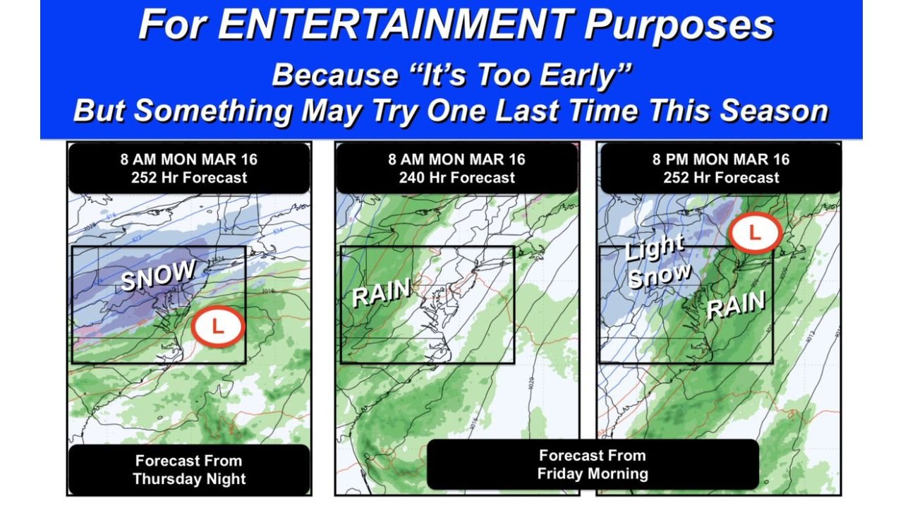
Recent long-range model guidance has displayed several different possibilities for the eastern United States around mid-March.
One earlier model projection suggested the potential for a modest East Coast snow event during the morning of March 16, with a developing low-pressure system positioned off the Mid-Atlantic coastline.
However, a later model run from the same forecast system produced a different outcome, showing rain instead of snow because colder air had not yet moved into the region at the time of the storm.
Another projection showed light snow developing later Monday night, illustrating how small shifts in timing could dramatically change precipitation type nearly ten days in advance.
These differences highlight the challenges of predicting storm systems at such long forecast ranges.
Timing of Cold Air Will Be the Key Factor
The most important variable in determining whether snow occurs will be the timing of colder air arriving across the Mid-Atlantic region.
If a storm system develops while colder air is already in place, precipitation could fall as snow. But if the storm arrives before temperatures drop sufficiently, the same system would likely produce rain instead.
Even a shift of several hours in the arrival of colder air can dramatically change the outcome.
Because the forecast period is still many days away, weather models continue to adjust with each new update.
Polar Vortex Stretch Expected Mid-Month
Long-range atmospheric patterns suggest there may be another stretching or displacement of the polar vortex during the middle of March, which can sometimes allow colder air to move southward into parts of the United States.
Computer models have detected signals of this pattern change, though the exact intensity and placement of the colder air remain uncertain.
The potential cooling period may last two to three days, briefly lowering temperatures across portions of the eastern United States.
Whether a storm system aligns with this colder window will determine if any winter weather develops.
March Snowstorms Are Rare but Not Impossible
Although winter typically begins fading by mid-March, snowfall events in the Mid-Atlantic are not unprecedented this late in the season.
In order for snow to accumulate during March, several factors generally must align:
- Temperatures must drop sufficiently to support frozen precipitation
- Snowfall often needs to occur at night, when surface temperatures are cooler
- Heavier snowfall rates are sometimes necessary to overcome warmer ground conditions
Because daytime sunlight becomes stronger in March, lighter snow events often melt quickly unless the storm is intense.
Forecast Confidence Remains Low
Despite early signals in long-range models, forecast confidence remains limited because computer models have struggled with accuracy at extended time ranges this winter.
Weather patterns nearly ten days in advance can change dramatically as new atmospheric data enters forecasting systems.
For now, the mid-March period simply represents a potential window for colder weather across the eastern United States, rather than a confirmed snowstorm.
Mid-March Weather Could Still Change
With more than a week remaining before the possible pattern shift, forecast models will continue to evolve as new data becomes available.
Small adjustments in storm track, temperature timing, or atmospheric pressure patterns could easily shift the outcome from snow to rain — or remove the storm altogether.
Residents across the Mid-Atlantic region should expect additional updates as the potential pattern change approaches.
Stay with WaldronNews for continued coverage of developing weather patterns and forecast updates across the United States.