
Dramatic Lake Michigan Temperature Divide Triggers Hail Threat in Chicago While Tornado Risk Builds Toward Central Illinois and Northwest Indiana
ILLINOIS — A sharp and highly unusual weather boundary is setting up across northern Illinois and northwest Indiana today (March 10), creating a striking contrast in storm threats depending on where you live. Just a few miles could mean the difference between a hail-producing elevated storm near Lake Michigan and a potentially tornado-capable surface-based storm farther south.
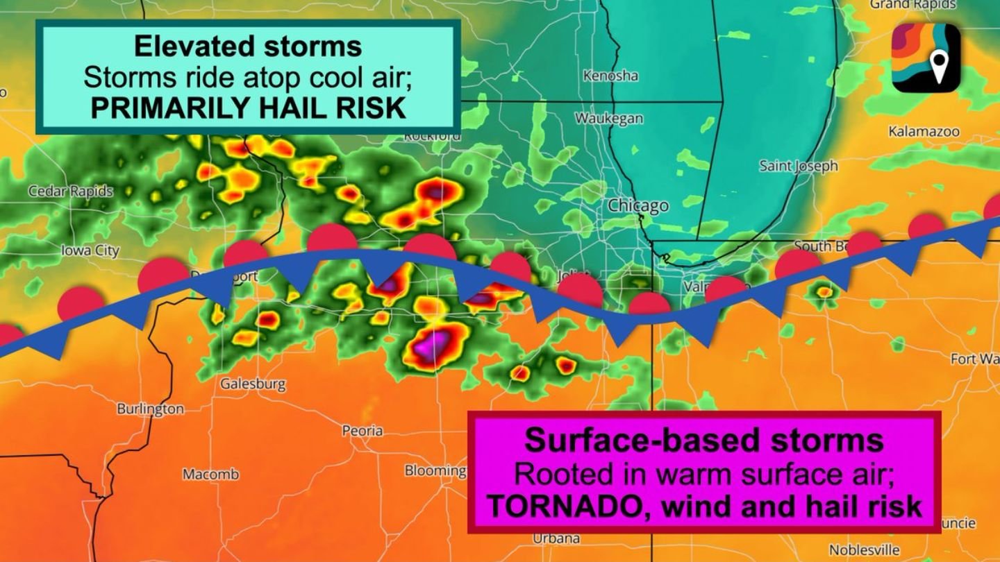
The dividing line? A shallow cool air mass hugging the Lake Michigan shoreline.
A Sharp Temperature Contrast Near Lake Michigan
Communities near the shores of Lake Michigan — including Chicago and surrounding areas — will sit north of a boundary where surface temperatures remain cooler. Meanwhile, central Illinois and portions of northwest and north-central Indiana are expected to warm dramatically into the mid to upper 70s.
That warmth will play a crucial role.
South of the boundary, thunderstorms will be surface-based, meaning they draw energy directly from warm, humid air near the ground. When storms are rooted at the surface, they are capable of producing:
- Tornadoes
- Damaging straight-line winds
- Large hail
This places central Illinois and parts of northwest Indiana in a more concerning setup for rotating storms later today.
Chicago Area: Elevated Storms and Hail as Primary Threat
North of the boundary — including Chicago and nearby communities — storms will behave differently.
Here, a shallow layer of cool air near the surface will prevent storms from tapping directly into ground-level instability. Instead, thunderstorms will become elevated, riding atop the cool air mass.
Elevated storms typically reduce tornado risk but significantly increase the potential for:
- Large hail
- Intense lightning
- Very loud thunder
Chicago-area storms today are expected to be primarily hail producers. While tornado risk is lower compared to areas farther south, the hail threat could still become significant if stronger cells develop.
Why Thunder Could Be Extra Loud in Chicago
Residents in Chicago may also notice something unusual — thunder that sounds exceptionally loud or echo-like.
The reason lies in the atmospheric structure.
Warm air about a mile above the surface will sit atop the shallow cool layer near the ground. This configuration acts like a ceiling in the lower atmosphere, allowing sound waves from thunder to bounce between the ground and roughly 5,000 feet above.
The result? Thunder that reverberates and echoes, creating a booming, prolonged rumble across the city.
South of the Boundary: Greater Tornado Potential
Farther south into central Illinois and extending into northwest and north-central Indiana, the atmosphere becomes more supportive of surface-based storms.
With temperatures climbing into the 70s and warm, humid air feeding developing thunderstorms, storms in these areas will be better positioned to rotate. That increases the concern for tornado development along with damaging winds and hail.
The exact placement of the boundary will determine which communities experience the more intense severe threat. Even small shifts north or south could significantly alter impacts.
What This Means for Residents
- Chicago and Lake Michigan shoreline areas: Prepare for hail-producing storms and unusually loud thunder.
- Central Illinois and northwest Indiana: Monitor conditions closely for potential tornado warnings and damaging winds.
- All areas near the boundary: Expect rapidly changing conditions within short distances.
Today’s setup is a classic example of how a shallow cool air mass near Lake Michigan can dramatically alter storm behavior across northern Illinois.
Residents across Illinois and Indiana should remain weather-aware through the afternoon and evening as storms develop along and south of the boundary.
Stay with WaldronNews.com for continued severe weather updates and analysis as this dynamic system evolves.