
Missouri, Illinois, Arkansas, Kentucky, Tennessee, Indiana, and Ohio Brace for Escalating Tornado Threat as March 10 Severe Outlook Upgrades from CIG1 to CIG2 Across the Mid-South and Ohio Valley
ARKANSAS — A rapidly evolving severe weather setup on March 10, 2026, shows a clear and concerning progression in forecast outlooks, with tornado risk intensifying from early Day 3 projections through multiple Day 1 updates across the Mid-South and Ohio Valley.
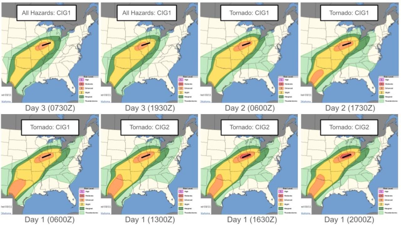
Newly analyzed categorical outlook progression maps reveal how the severe threat sharpened over time — both in coverage and intensity — placing portions of Missouri, Illinois, Arkansas, Kentucky, Tennessee, Indiana, and Ohio in a focused corridor for severe storms and tornado potential.
Day 3 Outlook: Early Signal for a Broad Severe Corridor
Initial Day 3 outlooks (0730Z and 1930Z updates) highlighted a broad severe weather swath stretching from parts of Texas and Arkansas northeastward through Missouri, Illinois, Indiana, and into Ohio.
At this stage, the outlook categorized the region under CIG1 (Category 1) for all hazards, indicating early but notable concern for organized severe weather. The highlighted corridor showed:
- A wide area of slight to enhanced severe risk (yellow and orange shading)
- A focused core zone extending from central Arkansas into southern Illinois and Indiana
- Stronger embedded signals across Missouri and Illinois
This early guidance already suggested a structured severe setup rather than isolated thunderstorm activity.
Day 2 Outlook: Tornado Risk Becomes More Defined
By Day 2 (0600Z and 1730Z updates), the outlook shifted specifically to tornado categorization under CIG1, refining the threat axis.
The tornado-focused outlook narrowed the highest concern into a corridor running from:
- Northern Arkansas
- Southeastern Missouri
- Southern and central Illinois
- Western Kentucky
- Southern Indiana
- Western Ohio
The yellow and orange shading intensified along this arc, signaling increasing confidence in supercell development capable of producing tornadoes.
Notably, the southern flank from eastern Texas into Arkansas remained involved, suggesting a multi-state severe event rather than a localized outbreak.
Day 1 Updates: Upgrade to CIG2 Indicates Escalating Concern
The most significant change appears in the Day 1 outlook progression (0600Z, 1300Z, 1630Z, and 2000Z updates).
As the event drew closer, the tornado outlook upgraded from CIG1 to CIG2, indicating a higher categorical level of concern.
The highest-risk corridor consolidated from:
- Eastern Arkansas
- The Missouri Bootheel
- Southern and central Illinois
- Western Kentucky
- Southern Indiana
- Into portions of Ohio
A more concentrated orange core developed within the broader yellow zone, highlighting where atmospheric conditions were becoming most favorable for tornadic supercells.
Additionally, a southern risk lobe remained across eastern Texas and parts of Louisiana, suggesting multiple storm clusters could be active across the larger system.
What This Progression Tells Us
The stepwise upgrade from CIG1 to CIG2 across successive outlooks reflects:
- Increasing model agreement
- Strengthening wind shear profiles
- Better-defined instability corridors
- Higher confidence in discrete supercell formation
When outlook categories escalate closer to the event, it typically indicates forecasters are observing improved environmental alignment for organized severe storms — especially tornado-producing systems.
The consistent northeast-oriented corridor from Arkansas through Illinois and into Ohio suggests a strong frontal boundary interacting with warm, unstable air surging northward from the Gulf region.
Arkansas in the Primary Impact Zone
For Arkansas specifically, the maps show the state positioned near the southern-to-central portion of the tornado corridor during later updates.
Eastern and northern Arkansas appear closest to the more concentrated shading during Day 1 upgrades, signaling heightened attention for severe thunderstorm development capable of producing damaging winds and tornadoes.
Given the progression shown, residents across the region would need to closely monitor watches and warnings as the system unfolds.
Regional Severe Setup Across the Mid-South and Ohio Valley
The geographic orientation of the risk zone — from Arkansas through Missouri and Illinois into Indiana and Ohio — reflects a classic Mid-South to Ohio Valley severe weather alignment.
Such setups often support:
- Fast-moving squall lines
- Embedded tornado circulations
- Discrete supercells ahead of the main line
- Damaging straight-line winds across a large footprint
The multi-update consistency and categorical upgrade underscore the seriousness of the March 10 severe weather setup.
Stay with WaldronNews.com for continued updates as we track severe weather developments across Arkansas and neighboring states.