
Washington, Oregon, Idaho Face Heavy Snow, High Winds, and Flood Threat as 180 MPH Jet Streak Slams Pacific Northwest While Montana, Colorado, and Texas Grapple With Red Flag Fire Danger
UNITED STATES — A powerful 180 mph jet streak is driving a high-impact weather pattern across the western United States, delivering heavy snow, damaging winds, and flooding to the Pacific Northwest while simultaneously triggering widespread fire danger and high wind alerts from Montana through Colorado and into Texas.
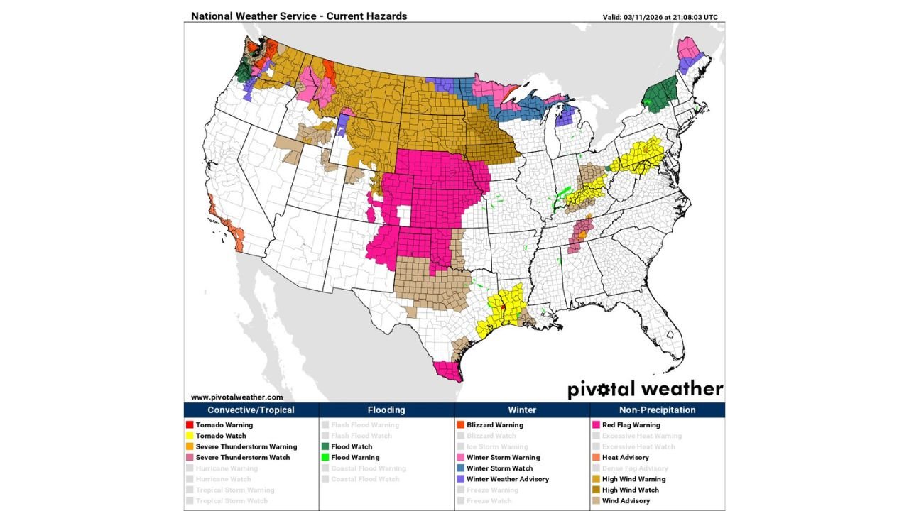
The latest National Weather Service hazard map shows a stark contrast between storm-battered coastal states and wind-swept, fire-prone regions farther inland.
Pacific Northwest Under Multi-Hazard Assault
Washington and Oregon are bearing the brunt of the atmospheric river and jet stream combination. Current alerts indicate:
- Winter Storm Warnings across parts of the Cascades and interior mountains
- Flood Watches and Flood Warnings in western Washington and northwest Oregon
- High Wind Warnings along portions of the coastline and higher elevations
The embedded atmospheric river is funneling deep Pacific moisture into the region, leading to heavy mountain snowfall while lower elevations face soaking rains and rising water concerns.
In Idaho and western Montana, winter weather advisories and storm warnings stretch across mountain corridors, signaling significant snowfall totals and hazardous travel conditions.
Flooding and Wind Concerns Expand
Green-shaded flood watches extend across portions of western Washington and into parts of the Northeast as well, indicating additional areas monitoring rising water.
Meanwhile, powerful upper-level winds associated with the 180 mph jet streak are translating to the surface, prompting widespread High Wind Watches and Warnings across:
- Montana
- Wyoming
- The Dakotas
- Nebraska
- Colorado
These wind alerts span a broad corridor across the northern and central Rockies and into the Plains, signaling gusts capable of damaging property and creating dangerous travel for high-profile vehicles.
Fire Weather Danger From Montana to Texas
In sharp contrast to the heavy snow and rain in the Northwest, much of the central United States is under significant fire weather concerns.
Large swaths of:
- Montana
- Wyoming
- Colorado
- Kansas
- Oklahoma
- Texas
are shaded under Red Flag Warnings, indicating critical fire weather conditions fueled by strong winds, low humidity, and dry fuels.
The concentration of red flag alerts across the High Plains and southern Plains underscores the volatile pattern — where strong wind fields are enhancing fire spread potential in already dry regions.
Severe and Thunderstorm Watches in the South
Additional severe weather components are visible farther south. Tornado and severe thunderstorm watches are in effect across portions of:
- Louisiana
- Mississippi
- Alabama
Yellow-shaded tornado watches along the Gulf Coast indicate the potential for rotating storms, adding yet another layer to this expansive national weather event.
A Coast-to-Coast High-Impact Pattern
This setup illustrates the power of a strong jet streak interacting with contrasting air masses:
- Deep Pacific moisture fueling heavy precipitation in the Northwest
- Strong downslope winds and dry air creating fire danger across the Rockies and Plains
- Instability along the Gulf Coast supporting severe thunderstorms
The 180 mph upper-level winds are acting as the engine driving these impacts, intensifying storm systems in the Northwest while accelerating wind speeds across the interior West.
Residents in affected states are urged to monitor local advisories closely, as conditions may evolve rapidly.
Stay with WaldronNews.com for continued coverage of this high-impact weather event stretching from the Pacific Northwest to the Southern Plains.