
Ontario and Quebec Hit by Worsening Freezing Rain Event as 30,000 Hydro One Customers Lose Power and Ice Band Stretches from Sudbury to Ottawa and Montreal
CANADA — A significant freezing rain event is unfolding across Ontario and Quebec, knocking out power to tens of thousands and threatening additional outages as the heaviest icing moves through this afternoon.
At last report, approximately 30,000 Hydro One customers in Ontario were without electricity. In neighboring Quebec, outage numbers have already climbed past 14,000 customers, with utility reports indicating totals are rising rapidly.
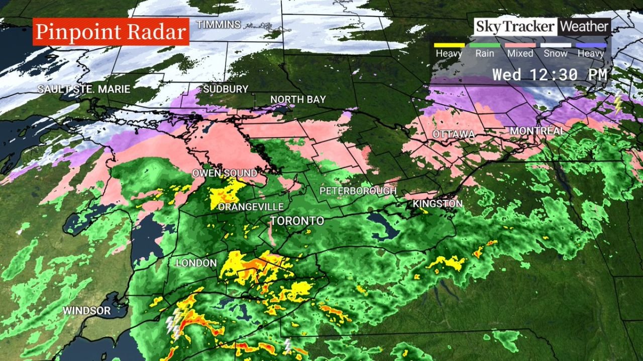
Ice Corridor Expands Across Southern and Eastern Ontario
Radar imagery shows a broad swath of freezing rain (pink shading) stretching across:
- Sudbury
- North Bay
- Owen Sound
- Orangeville
- Peterborough
- Ottawa
This icy band extends eastward into western Quebec, impacting areas around Montreal, where mixed precipitation and freezing rain are creating hazardous travel conditions.
South of the freezing rain line, steady rainfall and embedded thunderstorms are moving across:
- Toronto
- London
- Kingston
- Windsor
Meanwhile, heavier snow continues north of the ice zone toward Timmins and areas farther north.
Power Outages Likely to Increase
Freezing rain is especially dangerous because it coats surfaces with ice, adding weight to trees and power lines. Even a thin glaze can:
- Snap tree limbs
- Bring down entire trees
- Damage power infrastructure
- Block roadways
With the worst icing expected this afternoon, additional outages are likely as ice accretion increases.
Utility crews in both Ontario and Quebec are facing challenging conditions as freezing rain continues to accumulate on lines and equipment.
Major Cities in the Impact Zone
Communities currently within the freezing rain corridor include:
- Sudbury
- North Bay
- Ottawa
- Peterborough
- Montreal
Toronto sits near the transition zone between rain and freezing rain, where minor temperature shifts could change precipitation type.
Travel and Safety Concerns
Ice accumulation can create treacherous conditions quickly. Drivers may encounter:
- Slick highways and untreated roads
- Reduced braking effectiveness
- Falling branches
Pedestrians are also at risk for slips and falls as sidewalks glaze over.
Residents in affected areas are encouraged to avoid unnecessary travel and to prepare for potential extended power interruptions, particularly in rural communities where restoration can take longer.
A Dynamic and Dangerous Setup
The radar signature shows a classic winter storm structure, with:
- Snow in northern Ontario
- A central freezing rain band
- Heavy rain and thunderstorms to the south
As the system continues eastward, Quebec may see outage numbers rise further if icing intensifies.
Stay with WaldronNews.com for continued updates on this developing ice storm and power outage situation across Ontario and Quebec.