
Virginia and Washington, D.C. Plunge From 85–90° Heat to Widespread Snow in 24 Hours as Mid-Atlantic Swings From Summer to Winter
WASHINGTON, D.C. — A dramatic weather whiplash is unfolding across Virginia and the nation’s capital, where temperatures soaring into the mid-to-upper 80s Wednesday afternoon are expected to give way to widespread snow by the same time Thursday.
Forecast analysis shows readings between 85 and 90 degrees stretching across much of Virginia into Washington, D.C. at 4 p.m. Wednesday. By 4 p.m. Thursday, model guidance indicates precipitation changing over to snow across parts of Virginia and into the D.C. metro area — marking a near 50-degree collapse in temperatures in just 24 hours.
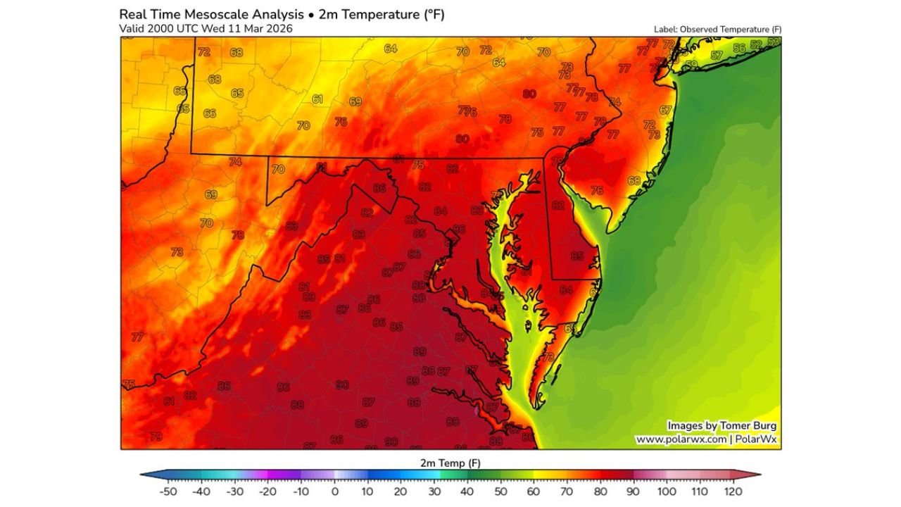
Wednesday: Near-Record Heat Across the Mid-Atlantic
Real-time temperature analysis Wednesday afternoon shows:
- Mid-to-upper 80s across central and eastern Virginia
- 85° to 88° common from Richmond through the D.C. metro
- Upper 80s pushing into southern Maryland
The heat surge places much of the region in a late-spring or even early-summer feel, with widespread red and orange shading dominating the temperature map.
This level of warmth in early March is notable on its own — but what follows is even more remarkable.
Thursday: Rain Changes to Snow Across Virginia and D.C.
By Thursday afternoon, precipitation is expected to overspread the Mid-Atlantic as a strong system pulls colder air southward.
Reflectivity and precipitation-type guidance shows:
- Rain transitioning to snow across western and central Virginia
- Snow bands extending toward northern Virginia
- Potential wet snow mixing into the Washington, D.C. area
- Snow continuing northward into Pennsylvania and New York
Blue-shaded snow zones appear across interior Virginia and portions of the Mid-Atlantic, with colder air wrapping in behind the departing system.
A 50-Degree Temperature Crash
Temperatures are forecast to tumble from:
- 85–90° Wednesday afternoon
- Down into the 30s by Thursday afternoon
That swing represents one of the sharper short-term transitions possible in the Mid-Atlantic — effectively going straight from summerlike heat to winter conditions within a single day.
Such compressed reversals are rare, particularly when accompanied by accumulating snow potential so soon after near-record warmth.
Impacts and Concerns
Because ground temperatures will start unusually warm, initial accumulation may be limited on paved surfaces. However, heavier precipitation rates could overcome that warmth, especially in elevated or grassy areas.
Potential impacts include:
- Slushy roads during heavier bursts
- Reduced visibility in snow bands
- Rapid changes in travel conditions
The weight of wet snow combined with gusty winds could also stress early-season vegetation that had responded to the warmth.
A Classic Mid-Atlantic Whiplash Setup
This system highlights the volatility of early March in the Mid-Atlantic, where strong frontal systems can tap both Gulf warmth and late-season Arctic air within hours.
Residents across Virginia, Washington, D.C., Maryland, and surrounding areas should be prepared for rapidly changing conditions between now and Thursday afternoon.
Stay with WaldronNews.com for continued updates as this remarkable 24-hour shift from 80s heat to snow unfolds across the region.