
Arkansas, Tennessee, Mississippi and Iowa Brace for Massive March 15 Storm as Tornado Threat and Midwest Blizzard Collide
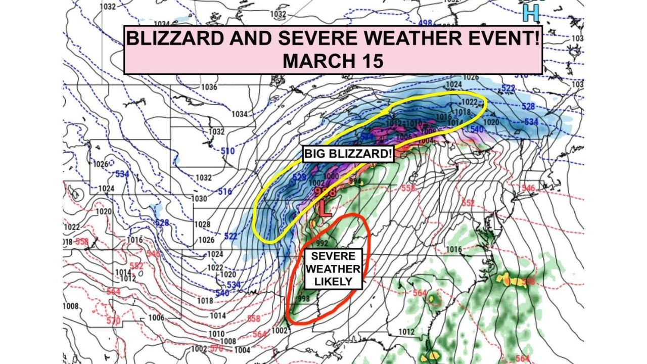
UNITED STATES — A powerful multi-hazard storm system is forecast to sweep across the central United States around March 15, potentially bringing a rare combination of severe thunderstorms, tornadoes, and blizzard conditions across different regions of the country. Meteorologists say the developing system could become one of the more impactful weather events of the early spring season as a strong mid-latitude cyclone organizes over the Midwest.
The evolving storm setup suggests a dramatic divide in weather impacts, with dangerous severe storms expected across the Mid-South, while a major winter storm and potential blizzard could unfold across Iowa and the Upper Great Lakes.
Severe Weather and Tornado Threat Focused on Arkansas and Tennessee
The most significant severe weather risk currently appears centered across the Mid-South region, particularly between Little Rock, Arkansas, and Memphis, Tennessee.
Forecast guidance highlights a corridor of unstable air stretching across:
- Arkansas
- Western Tennessee
- Northern Mississippi
- Eastern Oklahoma
This region is expected to sit within the warm sector of the developing storm system, where warm, moist air from the Gulf of Mexico interacts with strong upper-level winds.
Meteorologists warn that this setup could produce:
- Severe thunderstorms
- Large hail
- Damaging winds
- Possible tornadoes
The tornado threat may become especially elevated during the evening hours and after sunset, when the low-level jet intensifies and increases wind shear across the region.
Cities including Little Rock, Jonesboro, Memphis, and surrounding communities may need to closely monitor forecasts as the storm approaches.
Powerful Low Pressure System Driving the Storm
Weather maps indicate that a strong low-pressure system developing near the central Plains will drive the storm’s intensity.
The storm center is expected to deepen as it moves northeast across the Midwest, strengthening the pressure gradient and pulling warm, unstable air northward into the Mississippi Valley.
This setup creates the classic ingredients needed for both severe weather in the warm sector and heavy snow in the colder northern side of the storm.
Blizzard Conditions Possible Across Iowa and Upper Midwest
While the southern portion of the storm may produce severe weather, the northern side of the system could bring intense winter conditions.
Forecast projections show a broad zone of heavy snow stretching across:
- Iowa
- Minnesota
- Wisconsin
- Northern Michigan
Meteorologists say the storm could generate blizzard conditions, particularly across Iowa and parts of the Upper Midwest, where strong winds and heavy snowfall may combine to produce near-whiteout conditions.
The heaviest snow band is expected to form northwest of the storm’s center, where cold air collides with the system’s moisture.
Travel could become extremely dangerous in this region if snow and wind intensify simultaneously.
Why This Storm Could Become So Impactful
Large spring storm systems often bring multiple types of weather hazards at once, but this setup appears particularly potent because of the strong atmospheric dynamics involved.
Key ingredients contributing to the storm include:
- A rapidly strengthening low-pressure system
- A strong jet stream overhead
- Warm, moisture-rich air surging north from the Gulf
- Cold air wrapping into the system from the north
When these factors align, the result can be a large storm capable of producing severe weather in one region and blizzard conditions in another at the same time.
Multi-State Impacts Possible
Because the storm will span a large geographic area, impacts may stretch across multiple states including:
- Arkansas
- Tennessee
- Mississippi
- Oklahoma
- Iowa
- Minnesota
- Wisconsin
- Michigan
Each region may experience very different hazards depending on where they fall relative to the storm’s center.
Residents across the central United States are encouraged to monitor weather forecasts closely as meteorologists continue refining the details of this evolving system.
Forecasters Monitoring the Situation Closely
Although the event is still several days away, early forecast signals indicate that the storm has the potential to become a significant weather event impacting millions of people across the United States.
The combination of severe storms in the South and blizzard conditions in the Midwest makes this system particularly complex and potentially dangerous.
Weather agencies will continue evaluating new data over the coming days to determine where the most severe impacts are likely to occur.
Stay with WaldronNews for the latest updates as meteorologists track this developing storm and its potential impacts across Arkansas, Tennessee, Iowa, and the broader United States.