
Illinois Braces for Powerful Sunday Evening Squall Line as Damaging Winds and Possible Tornado Threat Target Chicago, Peoria, Springfield and Central Illinois
ILLINOIS — A fast-moving and potentially dangerous line of severe thunderstorms is forecast to move across Illinois Sunday evening, bringing the threat of damaging wind gusts and the possibility of embedded tornadoes as a powerful storm system sweeps through the Midwest.
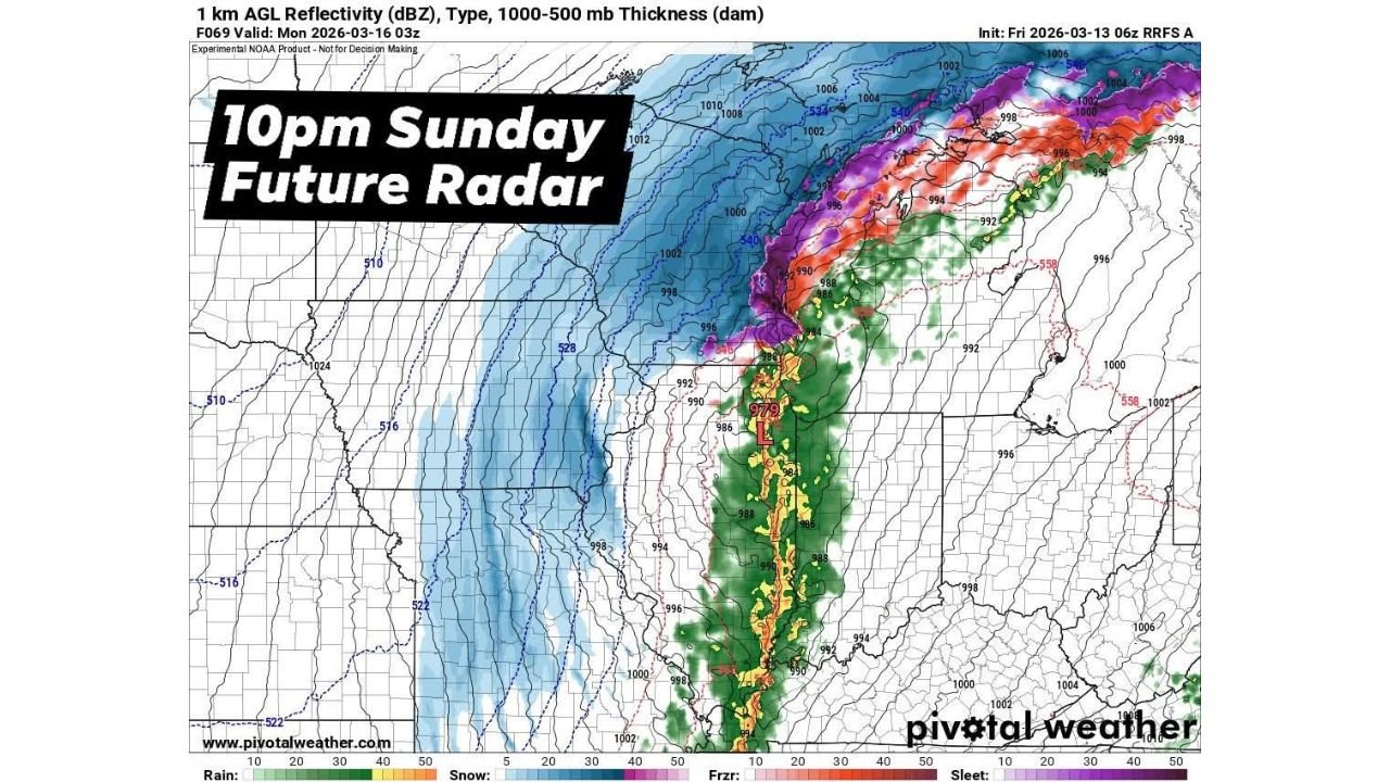
Forecast guidance and future radar projections show a large squall line organizing across Missouri and eastern Arkansas before pushing rapidly into Illinois, with the most intense storms expected Sunday night.
Meteorologists say the strongest parts of the storm line could produce significant wind damage and isolated tornadoes, especially where rotating storm segments develop along the front.
Squall Line Expected to Enter Western Illinois Sunday Evening
Model projections show thunderstorms consolidating into a long north-to-south oriented squall line ahead of a deep low-pressure system moving through the central United States.
The line is expected to push into western Illinois during the evening hours Sunday before racing eastward across the state through the night.
Communities that could experience severe weather as the line advances include:
- Quincy
- Peoria
- Springfield
- Bloomington
- Champaign
- Rockford
- Chicago metropolitan area
Storms may reach parts of central Illinois during the late evening, with the line continuing toward northern and eastern Illinois overnight.
Damaging Winds Likely the Biggest Hazard
The main concern with this type of storm system is strong straight-line winds, which can cause widespread damage as the squall line moves through.
Meteorologists warn that the most intense storms embedded in the line could produce wind gusts capable of:
- Knocking down trees
- Causing scattered power outages
- Damaging roofs and structures
- Blowing debris across roadways
Squall lines often generate large areas of wind damage, sometimes affecting multiple counties simultaneously as they move rapidly across a region.
Tornado Risk Cannot Be Ruled Out
While damaging winds are expected to be the primary threat, forecasters say isolated tornadoes may develop within the line of storms.
These tornadoes can form quickly when rotating segments develop within the squall line, making them harder to detect compared to traditional supercell storms.
Such tornadoes are commonly referred to as “embedded tornadoes,” and they often occur with little warning when the storm line passes through.
Powerful Storm System Driving the Outbreak
The severe weather threat is tied to a strong low-pressure system developing over the central Plains, which is forecast to deepen rapidly as it tracks northeast toward the Great Lakes.
As this system intensifies, it will pull warm, moist air northward into the Midwest while a powerful cold front pushes eastward, creating the ideal conditions for a line of severe thunderstorms.
Weather models show this system organizing into a classic cold-front squall line, which is known for producing widespread wind damage across large areas.
Rapid Storm Movement Could Increase Impacts
Another concern with Sunday’s storm system is how quickly the storms may move.
Fast-moving squall lines can travel at speeds exceeding 40 to 60 miles per hour, meaning storms may move through communities quickly but still produce intense wind gusts.
Because of the rapid movement, residents may only have a short window between severe weather warnings and the arrival of storms.
Residents Urged to Monitor Weather Alerts
Meteorologists urge residents across Illinois to stay alert for updated forecasts and potential watches or warnings as the system approaches Sunday evening.
Preparation steps include:
- Keeping weather alerts enabled on mobile devices
- Monitoring local forecasts through the afternoon and evening
- Identifying safe shelter locations inside homes
- Being prepared for possible power outages
Officials emphasize that even brief storms can produce significant damage when strong winds are involved.
Severe Weather Risk Continues to Develop
Forecast details such as the exact timing and intensity of storms across Illinois may change slightly as newer weather model data becomes available.
However, the current outlook suggests that a powerful squall line capable of damaging winds and isolated tornadoes will likely sweep across Illinois Sunday evening into Sunday night.
Stay with WaldronNews for continuing updates as meteorologists track this developing severe weather threat moving toward Illinois.