
Arkansas, Mississippi, Missouri, Kentucky and Tennessee Brace for Potential Tornado Outbreak Sunday Afternoon Into Night Across Mid-South and Ohio Valley
ARKANSAS — Meteorologists are warning that a potential severe weather outbreak could unfold Sunday afternoon and night, bringing the threat of significant tornadoes, damaging winds and large hail across parts of the Mid-South and Ohio Valley.
Forecast guidance indicates that the highest tornado threat will stretch from eastern Arkansas into northern Mississippi, southeastern Missouri, western Kentucky and Tennessee, before extending northward toward southern Illinois and southern Indiana later in the evening.
Forecasters say the most dangerous storms could develop between approximately 4 p.m. and midnight, when atmospheric conditions may become favorable for rotating supercell thunderstorms.
Tornado Risk Corridor Includes Memphis, Paducah and Nashville
The zone with the greatest concern for strong tornado development includes several major population centers across the region.
Cities located within or near the highest-risk corridor include:
- Memphis, Tennessee
- Jonesboro, Arkansas
- Paducah, Kentucky
- Cape Girardeau, Missouri
- Nashville, Tennessee
These areas lie within the portion of the storm system where warm, unstable air from the Gulf of Mexico will collide with strong wind dynamics in the atmosphere.
Meteorologists say this combination could allow storms to develop persistent rotation capable of producing tornadoes.
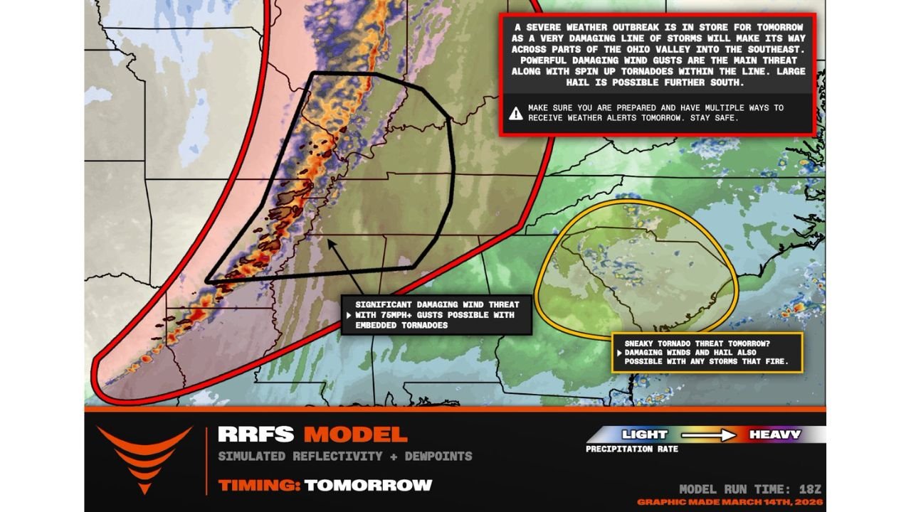
Damaging Squall Line Expected to Develop
Weather models suggest that thunderstorms will eventually organize into a powerful line of storms moving from west to east across the region.
This storm line could produce:
- Damaging wind gusts exceeding 75 mph
- Embedded tornadoes within the line
- Large hail in stronger storms farther south
Such systems can travel quickly and may produce severe conditions across multiple states within just a few hours.
The line of storms is expected to track from Arkansas and Missouri eastward toward Kentucky, Tennessee, Illinois and Indiana through the evening.
Secondary Storm Threat Across the Southeast
While the main severe weather outbreak is expected across the Mid-South and Ohio Valley, forecasters are also watching a secondary area of potential storm development farther south across parts of the Southeast.
If storms develop in this region, they could also produce:
- Damaging winds
- Large hail
- Isolated tornadoes
However, the greatest confidence for widespread severe weather remains farther north in the primary risk corridor.
Why This Setup Could Produce Significant Storms
The developing outbreak is tied to a strong storm system moving across the central United States, accompanied by a powerful cold front.
Several key ingredients for severe weather are expected to overlap Sunday:
- Strong upper-level winds
- Increasing atmospheric instability
- Moisture flowing north from the Gulf of Mexico
- A strong lifting mechanism along the cold front
When these ingredients combine, the atmosphere can support long-lived rotating thunderstorms known as supercells, which are capable of producing strong tornadoes.
Timing of the Severe Weather Threat
Current projections suggest the following general timeline:
- Early afternoon: Storms begin developing across Arkansas and Missouri
- Late afternoon into evening: Strong tornado potential increases across the Mid-South
- Evening into late night: Storms move northeast toward Kentucky, Tennessee, Illinois and Indiana
Because the threat continues into nighttime hours, some communities could experience severe weather after sunset.
Residents Urged to Prepare Before Storms Arrive
Weather officials are urging residents across the region to prepare for the possibility of severe weather Sunday.
Safety recommendations include:
- Having multiple ways to receive weather warnings
- Reviewing tornado safety plans
- Identifying safe shelter areas inside homes
- Monitoring updated forecasts throughout the day
Rapidly developing storms can produce dangerous conditions with little warning.
Meteorologists Continue Monitoring the Situation
Forecast details may continue to evolve as new model data becomes available.
However, early guidance strongly suggests that a potentially significant severe weather event could unfold across parts of Arkansas, Mississippi, Missouri, Kentucky and Tennessee on Sunday afternoon and night.
Stay with WaldronNews for continuing updates as meteorologists track this developing tornado and severe weather threat across the Mid-South and Ohio Valley.