
North Carolina, South Carolina and Virginia Face Two Rounds of Severe Storms Sunday Night and Monday With Tornado Risk and Damaging Winds Increasing
UNITED STATES — Forecasters are warning that two separate waves of severe weather could impact parts of the Southeast and Mid-Atlantic, bringing a higher-than-normal tornado risk and widespread damaging wind potential across North Carolina, South Carolina and Virginia from Sunday evening through Monday afternoon.
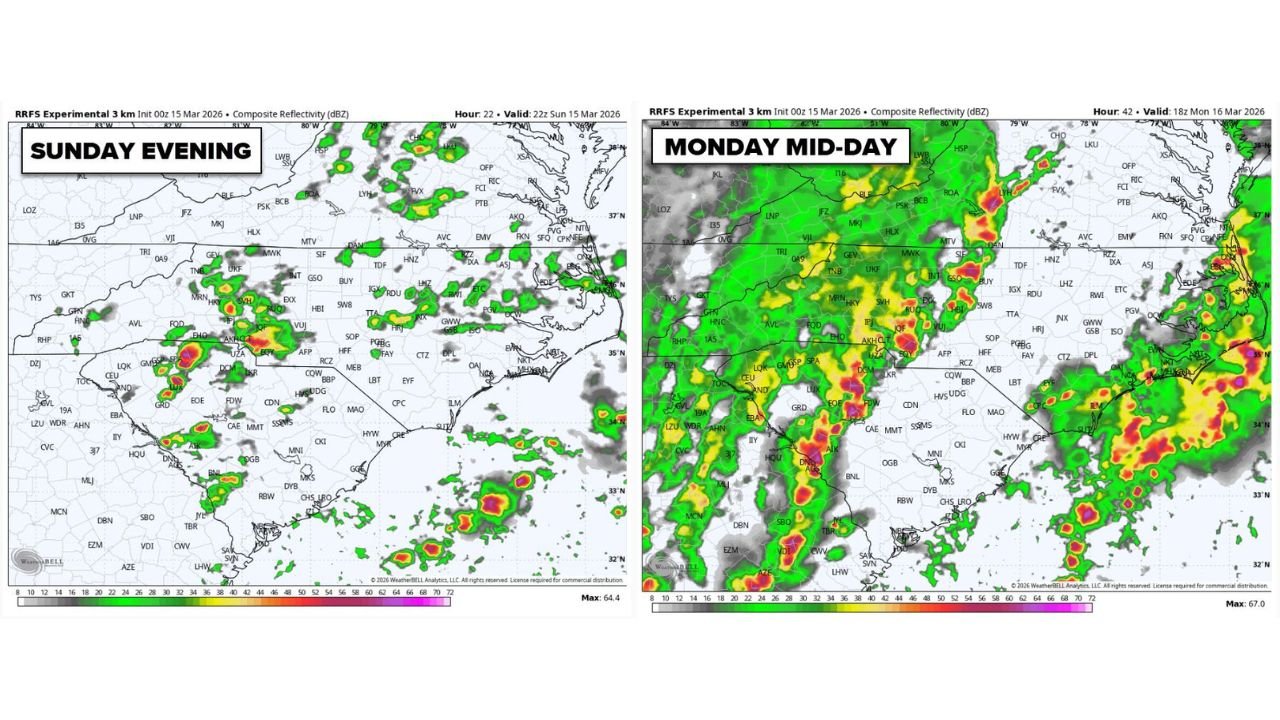
Weather models suggest the region could experience multiple rounds of thunderstorms, beginning Sunday evening and continuing again Monday as a powerful storm system moves through the eastern United States.
Meteorologists say residents across the Carolinas and surrounding states should remain weather aware as conditions could quickly become dangerous during both periods.
First Round of Severe Storms Expected Sunday Evening
The first wave of thunderstorms is expected to develop Sunday evening, primarily impacting areas across:
- North Carolina
- South Carolina
- Parts of Georgia
- Portions of Virginia
Forecast radar simulations show clusters of storms forming across the interior Southeast and moving eastward toward the Carolinas.
Some storms during this first round could become strong enough to produce:
- Damaging straight-line winds
- Heavy rain and lightning
- Isolated tornadoes
While not every storm will be severe, meteorologists say a few storms could intensify rapidly, especially during the evening hours when atmospheric instability remains elevated.
Second and Potentially Stronger Wave Monday Midday
A more organized line of thunderstorms is forecast to develop Monday as a strong cold front sweeps eastward across the Southeast and Mid-Atlantic.
Forecast models show a solid line of storms stretching from Georgia through the Carolinas and into Virginia, moving northeast during the late morning and afternoon hours Monday.
Cities potentially impacted include:
- Charlotte, North Carolina
- Raleigh, North Carolina
- Columbia, South Carolina
- Greenville, South Carolina
- Richmond, Virginia
This second wave may bring a greater risk of widespread damaging winds, as storms organize into a fast-moving squall line.
Tornado Risk Higher Than Normal
Meteorologists say this setup could support a higher-than-average tornado risk, particularly where storms interact with strong wind shear in the atmosphere.
Tornadoes embedded within the storm line may develop quickly and could occur with little warning.
Along with tornado potential, the storm system could produce:
- Wind gusts exceeding 60 to 70 mph
- Large hail in stronger cells
- Heavy rainfall and lightning
These hazards could lead to downed trees, scattered power outages and localized damage.
Why the Storm System Is Concerning
The severe weather threat is being driven by a powerful storm system moving across the eastern United States, pulling warm, moist air northward from the Gulf of Mexico.
As the cold front approaches, this warm air will collide with cooler air behind the front, creating the lifting needed for thunderstorms to develop.
At the same time, strong winds higher in the atmosphere will allow storms to organize and intensify, increasing the likelihood of severe weather.
When instability, wind shear and lift combine, the atmosphere becomes favorable for supercells and damaging storm lines.
Residents Urged to Have Multiple Ways to Receive Warnings
Because severe storms may occur during both evening and daytime hours, officials are encouraging residents to prepare in advance.
Weather experts recommend having at least three different ways to receive weather alerts, including:
- Wireless emergency alerts on smartphones
- Local weather apps or radio alerts
- Television or online weather updates
Having multiple warning sources can be critical during fast-moving storms.
Storm Timing Could Stretch Over Two Days
The overall severe weather timeline currently appears to be:
Sunday Evening
- Scattered thunderstorms developing across the Southeast
- Isolated severe storms possible
Monday Late Morning Through Afternoon
- Organized line of storms moving across the Carolinas and Virginia
- Increased threat for damaging winds and tornadoes
Because storms may develop in multiple waves, residents across North Carolina, South Carolina and Virginia could experience severe weather at different times.
Forecasters Monitoring Changes Closely
Meteorologists continue to analyze new forecast data as the storm system approaches, and the exact placement of the strongest storms could still change.
However, early indications suggest a two-day severe weather threat for the Carolinas and parts of Virginia, with the possibility of tornadoes and damaging winds during both rounds.
Stay with WaldronNews for the latest updates as forecasters track this developing severe weather threat across North Carolina, South Carolina and Virginia.