
Iowa Faces Rare Weather Clash as Blizzard Conditions and Severe Hail Threat Overlap Across Des Moines, Cedar Rapids and Waterloo
IOWA — A highly unusual weather setup is unfolding across Iowa this weekend as forecasters warn that blizzard conditions and severe thunderstorms capable of producing large hail may occur in the same region at nearly the same time.
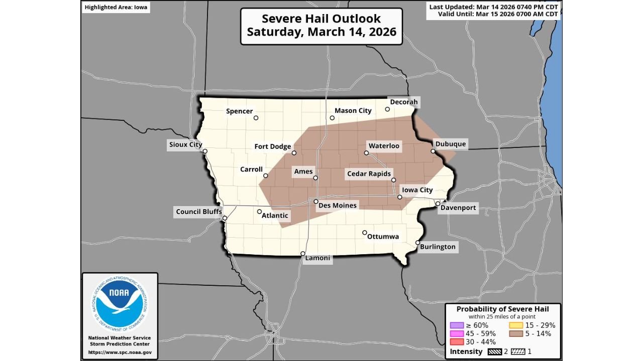
While much of the state is currently under a Blizzard Warning, the latest outlook from the Storm Prediction Center (SPC) has introduced a Marginal Risk for severe weather, highlighting the possibility of large hail developing within thunderstorms across central and eastern Iowa Saturday night.
Meteorologists say the rare overlap of winter storm conditions and severe thunderstorm potential reflects the extreme atmospheric contrasts present in the current storm system moving across the Midwest.
Severe Hail Risk Centered Across Central and Eastern Iowa
The latest severe weather outlook shows the greatest potential for hail developing across portions of central and eastern Iowa, including areas near:
- Des Moines
- Ames
- Cedar Rapids
- Waterloo
- Iowa City
These areas fall within the region where thunderstorms could briefly develop within the broader winter storm system.
The Storm Prediction Center indicates that storms forming in this environment could produce large hail despite the ongoing winter weather conditions surrounding them.
Blizzard Conditions Already Impacting Parts of the State
At the same time, Iowa is dealing with dangerous blizzard conditions caused by a powerful low-pressure system crossing the central United States.
Blizzard warnings are typically issued when the following conditions occur:
- Heavy snowfall
- Wind gusts exceeding 35 mph
- Visibility dropping below one-quarter mile
Such conditions can create whiteout visibility and hazardous travel across highways and rural roads.
The storm system responsible for the blizzard is also creating sharp temperature contrasts that can help thunderstorms form along the system’s southern and eastern edges.
Why Severe Storms Can Occur During a Blizzard
While it may seem unusual, severe thunderstorms can occasionally develop within powerful winter storm systems.
This occurs when warm, unstable air becomes wrapped into the circulation of a strong low-pressure system, creating localized pockets where thunderstorms can form.
In Iowa’s case, meteorologists say elevated instability within the storm system could support thunderstorms capable of producing large hail, particularly across the central part of the state.
These storms may develop briefly within the broader precipitation shield surrounding the winter storm.
Rare Combination of Winter and Severe Weather
Events where blizzard conditions and severe thunderstorm risks overlap in the same region are relatively rare, but they can occur during powerful spring transition storms across the Midwest.
The combination of:
- Strong wind fields
- Rapid temperature contrasts
- Intense storm system dynamics
can create an environment where snow, thunderstorms and hail occur within the same weather system.
This unusual setup has already sparked significant attention among meteorologists tracking the evolving conditions.
Travel Conditions May Become Extremely Hazardous
Officials warn that blizzard conditions combined with severe weather potential could create dangerous travel conditions across parts of Iowa.
Strong winds and blowing snow may reduce visibility significantly, while thunderstorms embedded in the system could produce bursts of hail or heavy precipitation.
Drivers are urged to monitor road conditions and avoid unnecessary travel during periods of severe weather.
Residents Urged to Monitor Weather Alerts
Because multiple types of hazardous weather may occur at once, officials recommend residents stay alert to rapidly changing conditions.
Safety recommendations include:
- Monitoring weather alerts and forecasts
- Avoiding travel during blizzard conditions
- Staying indoors during severe thunderstorms
- Preparing for possible power outages
Weather conditions may change quickly as the storm system continues moving across the Midwest.
Meteorologists Continue Tracking the Unusual Storm System
Forecasters say the evolving storm system will continue to produce a mix of winter weather and severe thunderstorm potential across parts of Iowa through Saturday night and early Sunday morning.
While the severe weather threat remains relatively limited, the combination of blizzard conditions and possible large hail makes this storm system particularly unusual.
Stay with WaldronNews for continuing updates as meteorologists monitor this rare weather combination impacting Iowa and the Midwest.