
Mississippi, Alabama, Tennessee and Georgia Brace for Dangerous Tornado Outbreak as Severe Storms Sweep Across the Mississippi Valley and Southeast
UNITED STATES — Meteorologists are warning that multiple tornadoes could develop Sunday across the Mississippi Valley and Southeast, as a powerful storm system creates an environment capable of producing strong, long-track tornadoes and widespread severe thunderstorms.
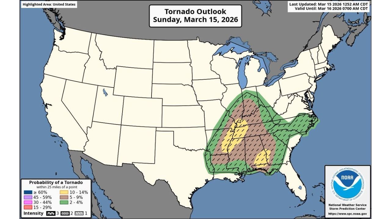
The latest tornado outlook highlights a broad swath of the central and eastern United States where conditions are expected to become favorable for rotating storms. The highest concern stretches across Mississippi, Alabama, Tennessee and Georgia, with the threat extending north toward Kentucky and southern Indiana and east into parts of the Carolinas.
Forecasters say this type of setup often signals the potential for a regional severe weather outbreak.
Strong Tornadoes Possible If Supercells Develop
Meteorologists say the biggest concern today involves discrete supercell thunderstorms, which are individual rotating storms capable of producing powerful tornadoes.
If these storms can form ahead of the main storm line, they could rapidly intensify and produce:
- Strong tornadoes
- Large damaging hail
- Destructive wind gusts
Supercells are particularly dangerous because they can maintain rotation for long periods of time, allowing tornadoes to remain on the ground longer and travel greater distances.
Weather analysts say that any isolated storms that develop in the unstable air ahead of the front will have the highest potential to produce significant tornadoes.
Mississippi Valley at the Center of the Severe Weather Threat
The tornado outlook map shows the core risk area across the Mississippi Valley, including portions of:
- Mississippi
- Alabama
- Tennessee
- Arkansas
- Louisiana
Cities that could experience severe storms today include:
- Jackson, Mississippi
- Birmingham, Alabama
- Memphis, Tennessee
- Nashville, Tennessee
- Little Rock, Arkansas
In these areas, warm and moist air from the Gulf of Mexico is expected to collide with a strong cold front, creating an environment that supports organized thunderstorms and rotating storms.
Severe Weather Threat Extends Into the Southeast
Beyond the Mississippi Valley, the severe weather threat expands eastward into Georgia, South Carolina and North Carolina, where storms could remain strong as they track across the Southeast.
While the tornado risk may be slightly lower in these areas compared with the Mississippi Valley, forecasters say damaging winds and isolated tornadoes remain possible throughout the region.
The severe weather system could impact millions of people across the Southeast before moving toward the Mid-Atlantic later.
Storm Timing and Preparedness
Because storms may develop rapidly throughout the day, meteorologists say residents across the Mississippi Valley and Southeast should remain weather-aware and prepared for warnings.
Officials recommend:
- Having multiple ways to receive weather alerts
- Enabling Wireless Emergency Alerts on smartphones
- Identifying safe shelter areas in homes
- Monitoring weather forecasts throughout the day
Forecasters stress that tornado warnings can be issued with very little lead time, especially when storms intensify quickly.
Residents Urged to Stay Alert as Severe Weather Unfolds
With atmospheric conditions becoming increasingly favorable for rotating storms, meteorologists say today could become one of the more active severe weather days of the early spring season.
Residents across Mississippi, Alabama, Tennessee and Georgia are encouraged to stay informed and be ready to take shelter if warnings are issued.
Stay with WaldronNews for continuing updates as forecasters track this developing tornado threat across the Mississippi Valley and Southeast.