
Illinois Storm Line Pushes Into Indiana Near Indianapolis as Severe Weather Threat Ends but Gusty Winds Continue Overnight
ILLINOIS — The severe weather threat has now moved out of Illinois after a strong line of thunderstorms pushed east across the region late Sunday night, but meteorologists say gusty winds could continue across parts of the state through Monday morning.
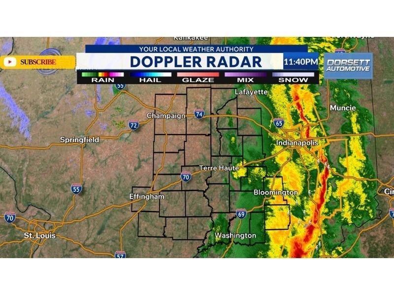
Doppler radar images late Sunday show the main storm line now east of the Illinois–Indiana border, with the strongest thunderstorms moving through Indianapolis and central Indiana shortly before midnight.
Communities across Champaign, Effingham, Terre Haute and surrounding areas in eastern Illinois are now seeing calmer conditions as the system exits the region.
Storm Line Swept Across Illinois Before Moving Into Indiana
Earlier in the evening, the storm system moved rapidly across Illinois from west to east, bringing periods of heavy rain and strong wind gusts to parts of the state.
By around 11:40 PM, radar imagery showed the most intense thunderstorms concentrated along a narrow line stretching through Indianapolis and Bloomington, Indiana, while areas across eastern Illinois were already behind the storms.
Cities including Springfield, Champaign and Effingham were largely clear of the severe storms as the line pushed eastward. Meteorologists say the storms were part of a larger weather system that tracked across portions of the Midwest Sunday evening.
Indianapolis Area Now Seeing the Strongest Storms
Radar imagery shows the most intense part of the line moving through central Indiana, particularly around:
- Indianapolis
- Bloomington
- Muncie
- Areas along Interstate 65 and Interstate 69
The narrow band of heavy rain and thunderstorms is continuing to track eastward, bringing strong winds and heavy rainfall to communities across Indiana.
Meanwhile, Illinois is now behind the storm system.
Gusty Winds Still Expected Overnight
Even though the severe weather threat has ended locally, meteorologists say gusty winds could continue through the overnight hours as the storm system moves farther east.
These winds often follow strong storm systems due to rapidly changing air pressure and cooler air moving in behind the front.
Residents across Illinois may still experience:
- Gusty overnight winds
- Brief scattered showers
- Cooler conditions by Monday morning
However, forecasters emphasize that the risk for severe thunderstorms has ended for the area.
Quieter Weather Returning by Monday Morning
As the storm system continues east into Indiana and the Ohio Valley, calmer weather is expected to settle across Illinois overnight. Skies should gradually clear into Monday morning while winds slowly weaken.
Meteorologists say the system responsible for Sunday night’s storms will continue moving across the eastern United States overnight.
Stay with WaldronNews for continuing weather updates as storm systems move across the Midwest and eastern United States.