
Cadillac and Missaukee County Michigan Hit by Dangerous Ice Storm as Heavy Freezing Rain Snaps Tree Limbs and Knocks Out Power
MICHIGAN — A dangerous ice storm is unfolding across parts of northern Michigan late Sunday night as a band of heavy freezing rain moves into the Cadillac region, coating roads, trees and power lines with thick ice and triggering widespread power outages.
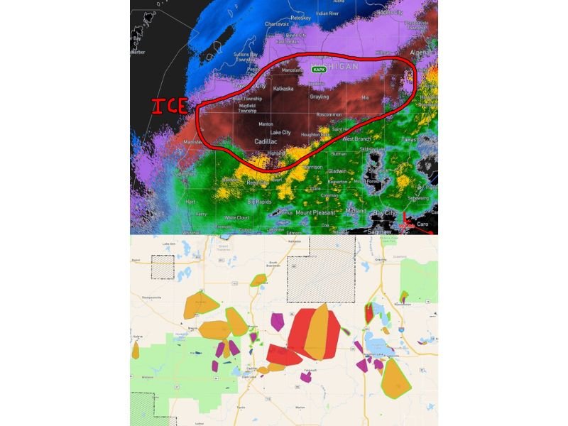
Weather reports indicate that significant icing is now occurring across areas south and east of Cadillac, with radar showing a concentrated band of freezing rain stretching across the region. Meteorologists say ice accumulation rates could reach 0.05 inches per hour or more, which is enough to rapidly build ice on exposed surfaces and begin causing structural stress to trees and utility lines.
Ice Storm Intensifying Along the M-55 and M-115 Corridor
The most dangerous icing is currently occurring along the M-55 and M-115 corridor, where freezing rain has been steadily falling for several hours.
Communities affected include:
- Cadillac
- Lake City
- Manton
- Kalkaska
- Grayling
- Mio
- Roscommon
Radar imagery shows a wide zone of freezing rain stretching from Manistee and Traverse City southeast toward Mio and West Branch, creating hazardous travel conditions across northern Lower Michigan.
Power Outages Rising Rapidly
Utility outage reports show power failures increasing quickly as ice begins weighing down tree limbs and power lines. In Missaukee County, officials report that approximately 37 percent of residents are currently without electricity, with outages rising rapidly as the storm intensifies.
Meteorologists warn that heavy ice accumulation can cause tree branches to snap suddenly, sometimes bringing down power lines and causing additional outages across affected communities. Because freezing rain can persist for several hours, some outages may last multiple days if damage becomes widespread.
Dangerous Conditions Developing Overnight
The heaviest icing currently appears concentrated in a band stretching across central northern Michigan, where radar imagery highlights the most intense freezing rain. Areas within the circled zone on radar imagery — including Cadillac, Lake City and surrounding communities — are likely experiencing the greatest ice accumulation.
Officials warn that the combination of falling ice, tree damage and slick road conditions could make travel extremely dangerous overnight. Drivers are being urged to use extreme caution, especially on rural roads where ice may accumulate quickly.
Residents Urged to Avoid Trees and Power Lines
Safety officials are advising residents in the affected region to avoid parking or driving under trees and power lines, as ice buildup can cause branches to fall suddenly. Strong ice accumulation can cause limbs to break without warning, creating hazards for both vehicles and pedestrians.
Residents should also prepare for possible extended outages by:
- Charging mobile devices
- Keeping flashlights and emergency supplies ready
- Avoiding unnecessary travel overnight
Ice Storm Could Continue Into Monday Morning
Forecast updates indicate freezing rain may continue across parts of northern Michigan through the overnight hours and into Monday morning, allowing additional ice to accumulate before temperatures eventually rise.
Meteorologists say conditions will gradually improve once the storm system shifts east, but dangerous icing and power outages may linger in the hardest-hit areas. Stay with WaldronNews for continuing updates as severe icing and power outages impact communities across northern Michigan.