
North Carolina, Virginia and Maryland Face Dangerous Level 4 Severe Weather Threat Today With Potential Strong Tornadoes
UNITED STATES — A significant severe weather outbreak is expected to develop across the Mid-Atlantic today as meteorologists warn that fast-moving storms could produce damaging winds exceeding 70 mph and potentially strong tornadoes across several states.
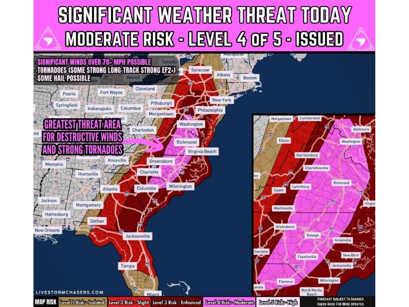
Forecasters have issued a Moderate Risk (Level 4 out of 5) for severe weather across parts of the region, signaling the potential for widespread impacts as storms organize and intensify throughout the day.
The greatest concern stretches from North Carolina through Virginia, Maryland and into parts of Pennsylvania, where atmospheric conditions appear favorable for dangerous thunderstorms.
Strong Tornadoes and Destructive Winds Possible
Meteorologists say the primary threats from today’s storms include tornadoes, widespread damaging wind gusts and isolated hail.
Some tornadoes could become strong (EF2 or greater) if storms remain isolated long enough to develop rotating supercells before merging into a larger storm line.
Experts say very strong wind shear combined with increasing daytime heating may allow storms to intensify quickly. If that happens, a few storms could produce long-track tornadoes capable of traveling several miles while maintaining strength.
Damaging Wind Gusts Could Exceed 70 MPH
Another major threat comes from a rapidly developing squall line expected to form along an advancing cold front.
As the line of storms pushes eastward, forecasters warn it could produce widespread damaging wind gusts between 60 and 75 mph, capable of downing trees, damaging buildings and knocking out power.
These storms are expected to move quickly, meaning communities could experience sudden severe conditions with little time to react.
Greatest Risk Zone From North Carolina to Virginia
The corridor with the highest potential for destructive storms includes portions of:
- North Carolina
- Virginia
- Maryland
- Southern Pennsylvania
Cities such as Charlotte, Greensboro, Raleigh, Richmond, Washington D.C., Baltimore and Philadelphia fall within the broader severe weather risk zone.
Meteorologists say the combination of moist air, strengthening wind fields and daytime heating will help storms organize across the region.
Storm Timeline Through the Day
Weather experts say storms will likely develop and intensify in stages throughout the day.
Late Morning to Early Afternoon:
Storms begin developing across the Carolinas and nearby Mid-Atlantic regions.
Afternoon:
Fast-moving supercells capable of producing tornadoes may develop ahead of the main storm line.
Afternoon into Evening:
A large squall line moves eastward across the region bringing widespread damaging winds.
Because the storms will be moving rapidly, conditions could change quickly as severe weather spreads from west to east.
Residents Urged to Prepare for Severe Weather
Officials are urging residents across the Mid-Atlantic to remain alert throughout the day and be prepared to take action if warnings are issued.
Safety experts recommend:
- Having multiple ways to receive weather alerts
- Identifying a safe shelter location inside homes
- Avoiding travel during severe storms if possible
Forecasters emphasize that severe weather outbreaks with a Level 4 risk designation are relatively uncommon, highlighting the seriousness of today’s storm potential.
Stay with WaldronNews for continuing updates as dangerous severe storms threaten parts of the Mid-Atlantic with damaging winds and possible tornadoes today.