
California, Nevada, Colorado, Utah and Arizona Snowpack Plunges to Just 8 Percent of Median as Peak Week Arrives With Almost No Snow Left
WESTERN UNITED STATES — At a time of year when mountain snowpack typically reaches its seasonal maximum, new data shows the snowpack across California, Nevada, Colorado, Utah and Arizona is nearly depleted.
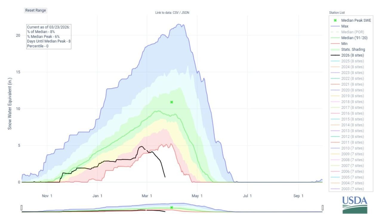
According to USDA snow water equivalent (SWE) data dated March 23, 2026, the current snowpack stands at just 8 percent of the median for this date — and only 6 percent of the typical median peak.
Late March is historically when snowpack across much of the West either peaks or approaches its annual high before the spring melt begins. Instead, this year’s accumulation is tracking near the bottom of the historical range.
Snowpack Near Record Lows Across the West
The data indicates:
- Current SWE: 8% of median (as of March 23, 2026)
- Percent of Median Peak: 6%
- Days Until Median Peak: -8 (meaning the normal peak period has already passed)
- Percentile Rank: 0
A percentile rank of zero suggests snowpack conditions are at or near the lowest observed levels in the period of record.
The 2026 snowpack curve sits dramatically below the shaded historical median range, far beneath even the lower bound of most past seasons.
Peak Week With Almost Nothing to Melt
Under normal conditions, snow water equivalent across mountain basins in California’s Sierra Nevada, Nevada’s higher terrain, Colorado’s Rockies, Utah’s Wasatch and Arizona’s mountain regions steadily climbs through winter and tops out in late March or early April.
This year, however, accumulation never approached typical seasonal levels. Instead of cresting near the median peak line — which historically sits far higher — the current snowpack has already begun collapsing toward near-zero values.
Historical maximum years have exceeded 20 inches of SWE at peak in many western basins. In contrast, 2026’s levels remain dramatically suppressed.
Water Supply and Drought Concerns
Snowpack in the Western United States acts as a natural reservoir, gradually releasing water through spring and early summer.
With snowpack nearly absent heading into the primary melt season, potential impacts include:
- Reduced runoff into rivers and reservoirs
- Increased drought risk in parts of California and Nevada
- Strain on agricultural and municipal water supplies
- Elevated wildfire risk heading into late spring and summer
The timing makes the situation especially concerning, as late March typically represents the most stable and water-secure point of the year for snow-dependent states.
A Historically Weak Winter
The 2026 snow season is tracking well below average across multiple Western states, with the current trajectory among the lowest in the historical dataset shown.
With April approaching, the window for meaningful recovery is narrowing quickly.
The Bottom Line
As California, Nevada, Colorado, Utah and Arizona enter what should be their annual snowpack peak, levels have collapsed to just 8 percent of median — signaling one of the weakest late-winter snow seasons on record.
Stay with WaldronNews.com for continued coverage of major weather and water developments across the United States.