
Oklahoma, Kansas, Nebraska, Iowa, Missouri and Illinois Enter Active Severe Weather Pattern From March 31 Through April 10
CENTRAL UNITED STATES — A developing weather pattern is signaling an uptick in severe storm potential across Oklahoma, Kansas, Nebraska, Iowa, Missouri and Illinois as the calendar turns from late March into early April.
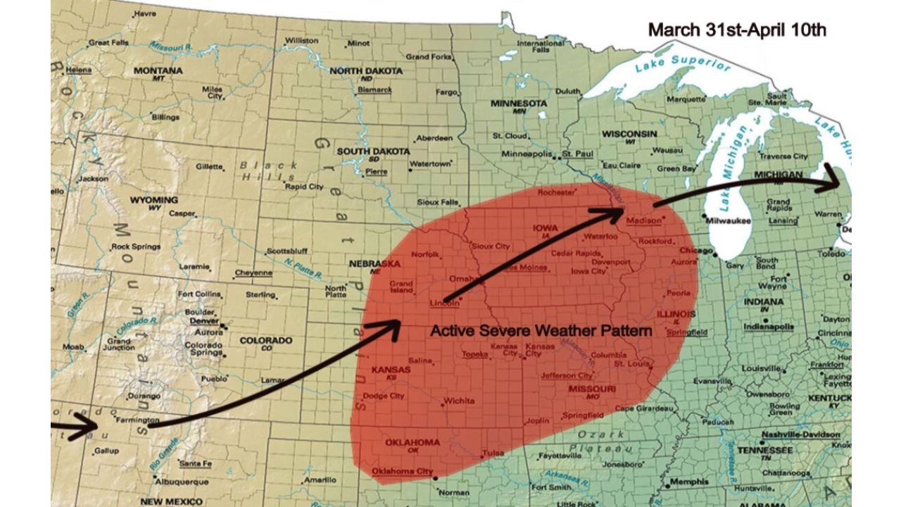
According to the latest outlook covering March 31 through April 10, a broad zone of the central Plains and Midwest is highlighted for an “Active Severe Weather Pattern,” suggesting repeated storm opportunities as atmospheric ingredients align.
Core of the Risk: Southern and Central Plains
The shaded region on the map centers over:
- Oklahoma
- Kansas
- Southern Nebraska
- Much of Iowa
- Northern and central Missouri
- Western and central Illinois
Cities including Oklahoma City, Wichita, Lincoln, Omaha, Des Moines, Kansas City, Columbia and Springfield sit within the outlined area.
This corridor represents a classic early spring transition zone where warm Gulf moisture, strengthening jet stream winds and advancing storm systems begin to overlap more frequently.
Pattern Setup Extends Into the Midwest
The highlighted zone stretches northeastward from the southern Plains into the Upper Midwest, reaching toward southern Minnesota and western Wisconsin.
The arrowed flow on the map suggests a consistent southwest-to-northeast storm track, a common signal for multiple rounds of severe weather episodes rather than a single isolated event.
Communities across Iowa and Illinois, including areas near Cedar Rapids, Waterloo, Rockford and Chicago, could see increased storm chances during this period if the pattern verifies.
Why Late March and Early April Matter
The transition from March into April typically marks a seasonal shift:
- Increasing daytime warmth across the Plains
- Strengthening upper-level wind support
- Expanding moisture return from the Gulf of Mexico
When these elements overlap across states like Oklahoma, Kansas and Missouri, severe thunderstorms become more likely, particularly during multi-day active patterns.
The forecast window from March 31 through April 10 suggests strong agreement in longer-range guidance that this setup may persist into the first full week of April.
Repeated Opportunities Possible
Rather than pointing to one specific outbreak, the highlighted region indicates a broader pattern supportive of:
- Thunderstorms capable of becoming severe
- Multiple storm systems tracking across the same corridor
- Increased storm frequency compared to recent weeks
For areas such as Oklahoma City, Wichita, Kansas City, Des Moines and St. Louis, this could mean staying weather-aware over several consecutive days.
The Bottom Line
An active severe weather pattern is projected to develop from Oklahoma and Kansas through Nebraska, Iowa, Missouri and Illinois between March 31 and April 10, marking a notable shift into a more storm-favorable regime as April begins.
Residents across the central Plains and Midwest should monitor updated forecasts in the coming days as the setup becomes clearer.
Stay with WaldronNews.com for continuing coverage of severe weather developments across the United States.