
Iowa Temperatures Crash From 90s to 30s in Under 24 Hours as Arctic Air Slams Midwest Including Minnesota, Wisconsin and Illinois
IOWA — A dramatic temperature reversal stunned the Midwest as readings in parts of Iowa plunged from the 90s into the 30s in less than 24 hours, marking one of the most extreme swings of the season.
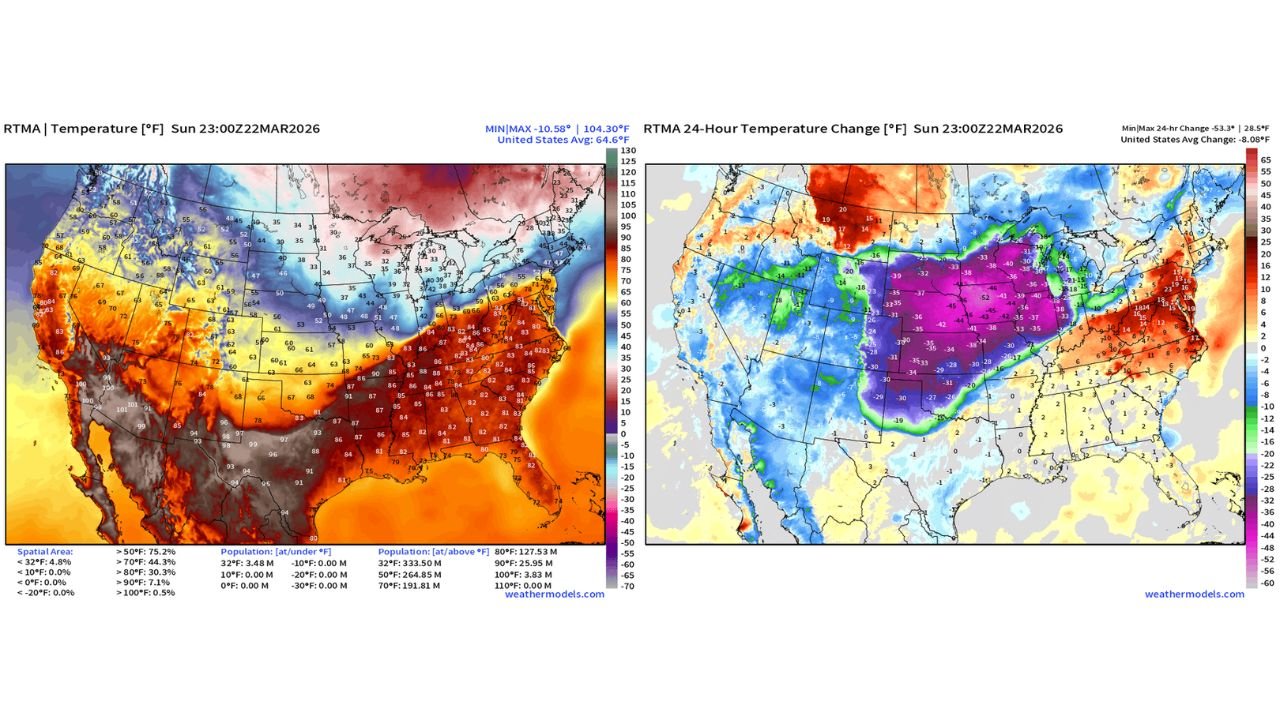
Data from late Sunday evening shows temperatures across Iowa running as much as 53 degrees colder at 6 PM CT compared to 6 PM Saturday, a rapid shift driven by a surge of Arctic air pouring south from Canada.
From Heat Dome to Arctic Blast
Just a day earlier, much of Iowa, Missouri and Illinois was baking under an intense warm spell, with widespread 80s and 90s stretching from the Southern Plains into the Mid-Mississippi Valley.
Temperature maps from Saturday evening show:
- 90s across portions of Iowa
- Upper 80s to low 90s in Missouri
- 80s extending into Illinois
By Sunday evening, the pattern had completely flipped.
Midwest Plunges Into the 30s
Behind a powerful cold front, Arctic-origin air surged southward across the Plains and Upper Midwest.
Updated readings show:
- 30s and low 40s across Iowa
- 30s in southern Minnesota
- 30s and low 40s in Wisconsin
- Sharp cooling spreading into northern Illinois
The 24-hour temperature change map highlights a core of -35 to -53 degree drops centered over Iowa, with surrounding areas in Nebraska, South Dakota, Minnesota and Wisconsin also experiencing 25 to 45 degree declines.
A Classic Midwest Whiplash
This rapid reversal is often described as “climate whiplash” — a sudden swing from summerlike warmth to winterlike chill.
In this case:
- Saturday evening: Iowa in the 90s
- Sunday evening: Iowa in the 30s
- Net change in some locations: 50+ degrees colder
The boundary separating warm and cold air advanced quickly, leaving little transition time between seasons.
How It Happened
The extreme swing was fueled by:
- A departing ridge of high pressure that had trapped heat over the central U.S.
- A strong cold front sweeping southeast
- A surge of Canadian Arctic air replacing the previous warm air mass
The contrast between the departing heat and incoming cold air mass intensified the magnitude of the temperature change.
Impacts Across the Region
The rapid drop affected multiple states beyond Iowa, including:
- Minnesota
- Wisconsin
- Illinois
- Eastern Nebraska
- Northern Missouri
Residents went from short sleeves to winter jackets within a single day.
Such sharp temperature gradients can also increase wind speeds and create volatile weather transitions along the frontal boundary.
The Bottom Line
Iowa experienced a staggering plunge from the 90s to the 30s in under 24 hours, with temperatures running as much as 53 degrees colder compared to the same time the day before. The Arctic air mass also sent readings tumbling across Minnesota, Wisconsin and Illinois.
It’s a vivid reminder of how quickly conditions can change across the central United States during seasonal transitions.
Stay with WaldronNews.com for continuing coverage of major weather swings across the country.