
Rotating Supercells With EF2 Tornadoes and Baseball Sized Hail Target Northeast Iowa, Southern Wisconsin and Northern Illinois Tuesday as Dubuque, Madison, Milwaukee and Chicago Face Substantial Severe Weather Risk
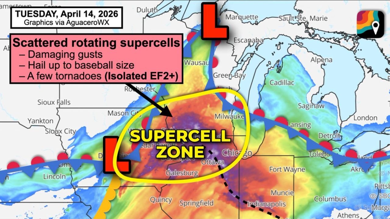
CHICAGO, Illinois — A substantial and dangerous severe weather outbreak is locked in for Tuesday, April 14 across northeast Iowa, southern Wisconsin, and northern Illinois — as scattered rotating supercell thunderstorms carrying baseball-sized hail, damaging wind gusts, and isolated EF2+ tornadoes target a corridor stretching from Dubuque, Iowa through Madison and Milwaukee, Wisconsin and into the Chicago, Galesburg, and Ottawa, Illinois metro areas during Tuesday’s afternoon and evening hours.
The atmosphere on Tuesday is loaded with moderate to extreme instability — an enormous pool of warm, humid air surging northward ahead of a low pressure center positioned in southwestern Iowa — creating thunderstorm fuel described simply as a LOT. Storms that develop along the Wisconsin-Illinois border and lift northeast into this potent environment will immediately have access to everything they need to become violent, long-lived, and extremely dangerous.
The Supercell Zone — Greatest Risk Corridor
The Supercell Zone identified for Tuesday is centered on one of the most precisely defined and dangerous threat corridors of this entire multi-day outbreak:
- Iowa: Dubuque sits at the southwestern anchor of the greatest risk corridor — directly in the zone where storms lifting northeast off the Wisconsin-Illinois border will be most organized and dangerous
- Wisconsin: Madison and Milwaukee are explicitly named as sitting within the greatest risk corridor for Tuesday — the Dubuque to Madison to Milwaukee line is where tornado and baseball-sized hail potential is highest
- Illinois — Northern: Chicago, Ottawa, Galesburg, Davenport, and the broader northern Illinois corridor fall within the supercell zone where additional supercells are likely — hail, wind, and a couple of tornadoes are expected in this area
- Wisconsin — Northern: Wausau and northern Wisconsin communities face a hail threat even as the tornado risk diminishes north of the warm front — storms riding the cool side of the boundary maintain their hail-producing capability even as tornado potential decreases
- Iowa — Northeast: Mason City, Cedar Rapids, and the broader northeast Iowa corridor are within the active storm development zone
Three Threats — All Simultaneously Active Tuesday
EF2+ Isolated Significant Tornadoes: Tornadoes are not just possible Tuesday — several significant tornadoes rated EF2 or stronger are explicitly on the table for the greatest risk corridor from Dubuque through Madison to Milwaukee. Two specific atmospheric mechanisms are enhancing the tornado threat:
First, storms forming along the Wisconsin-Illinois border and lifting northeast are entering an environment of exceptional instability and wind shear — the combination that produces the most organized and dangerous rotating supercells. Second, a leftover outflow boundary — the remnant exhaust from Monday night’s storms — is sitting across northern Illinois and could significantly enhance the low-level atmospheric twist available to storms tracking through that area. When a supercell encounters an outflow boundary, it can suddenly and rapidly intensify its rotation — producing tornadoes with very little additional warning time.
Baseball-Sized Hail: The extreme instability in place Tuesday — described as a LOT of storm fuel — combined with dry air at the mid-levels of the atmosphere creates ideal conditions for very large hailstone growth. Baseball-sized hail measuring approximately 2.75 inches in diameter is possible in the strongest supercells tracking through the Dubuque, Madison, Milwaukee, and Chicago corridor. This size of hail is capable of destroying vehicle windshields instantly, punching through roofing materials, shattering windows, and causing serious injury to anyone caught outdoors.
Damaging Wind Gusts: Every supercell that develops Tuesday will carry the threat of damaging straight-line wind gusts in addition to hail and tornado threats. The combination of extreme instability and strong upper-level winds creates downdraft potential that can produce wind gusts capable of downing trees, snapping power lines, and causing widespread structural damage across the storm track.
Why the Dubuque to Madison to Milwaukee Corridor Is the Bullseye
The greatest severe weather risk on Tuesday is explicitly concentrated along the Dubuque, Iowa to Madison, Wisconsin to Milwaukee, Wisconsin corridor — and the atmospheric reasoning is specific and alarming.
A low pressure center in southwestern Iowa is lifting warm, humid air northward ahead of it — creating the moderate to extreme instability pool that covers the entire threat zone. Storms that develop along the Wisconsin-Illinois border — where the atmospheric forcing is strongest — will immediately be lifting northeast into the richest portion of this instability field. As they track toward Madison and Milwaukee, they will be operating in an environment where CAPE values are at their peak and wind shear is most favorable for sustained supercell rotation.
The purple core of extreme instability visible on Tuesday’s atmospheric map — centered directly over the Dubuque to Chicago corridor — represents the absolute highest concentration of thunderstorm fuel available Tuesday. Any storm that develops within or tracks through this purple zone will have access to atmospheric energy levels rarely seen this far north this early in the spring season.
Northern Illinois — The Outflow Boundary Wildcard
Northern Illinois faces a specific and additional severe weather concern Tuesday that is separate from the primary warm front dynamics driving the Wisconsin threat. A leftover outflow boundary from Monday night’s storms is expected to remain draped across northern Illinois Tuesday — and this boundary acts as a hidden enhancement zone for tornado production.
When Tuesday’s supercells encounter this outflow boundary as they track into northern Illinois, the boundary can dramatically increase the low-level helicity — the atmospheric twist near the surface that rotating supercells feed on to produce tornadoes. This enhancement mechanism is responsible for some of the most unexpected and violent tornado episodes in Midwest severe weather history, because storms that appear to be weakening or organizing can suddenly explode in intensity when they hit a favorable boundary.
For communities including Chicago, Ottawa, Galesburg, and Davenport, the outflow boundary makes Tuesday’s tornado threat less predictable but potentially more intense in localized areas depending on exactly where the boundary is positioned when storms arrive.
Not Everyone Gets Hit — But Those Who Do Face Danger
Tuesday’s severe weather will not be a wall-to-wall event across the entire risk zone. Scattered supercells means some communities will see nothing while neighboring areas experience violent and life-threatening storms. This is one of the most challenging communication realities of Tuesday’s setup — the uneven distribution of storm activity makes it impossible to say with certainty which specific city will take the direct hit and which will be spared.
What is certain is that every community from Dubuque through Madison, Milwaukee, and Chicago sits within the zone where a direct supercell hit is possible — and the storms that do develop will be significant and potentially dangerous. The uncertainty about exactly which communities get hit is not a reason for complacency — it is a reason for universal preparation across the entire corridor.
What Every Resident From Dubuque to Chicago Must Do Before Tuesday Afternoon
- Identify your lowest-floor interior shelter room right now — if a tornado warning is issued for your county Tuesday, you need to already be moving to that room, not searching for it
- All vehicles in the Dubuque, Madison, Milwaukee, and Chicago metro areas should be under covered parking before Tuesday afternoon — baseball-sized hail will cause catastrophic and instant damage to any vehicle left outdoors
- Ensure weather alerts are set to override Do Not Disturb on your phone — given Monday night’s late storm activity, some residents may be fatigued from overnight alerts but Tuesday’s threat is real and separate
- The outflow boundary across northern Illinois makes Chicago and surrounding communities a particular wildcard — if your alerts go off Tuesday, treat them with maximum urgency regardless of how the morning weather looks
- Watch for tornado watches to be issued Tuesday morning — a watch covering the Dubuque to Milwaukee corridor should be treated as a signal to finalize all preparations and be ready to shelter immediately
- Northern Wisconsin residents near Wausau should monitor hail alerts even though the tornado threat is reduced north of the warm front — baseball-sized hail is still possible in this zone
From Dubuque and Madison in the west to Milwaukee and Chicago in the east, Tuesday is shaping up as one of the most dangerous severe weather days the Midwest has seen this spring. The atmosphere is loaded, rotating supercells are expected, and EF2+ tornadoes are explicitly on the table for the greatest risk corridor.
WaldronNews.com will continue tracking Tuesday’s supercell outbreak across Iowa, Wisconsin, and Illinois and will provide updates as storm development, tornado watches, and warnings are issued throughout the day.