
Florida Wildfire Threat Tuesday as Humidity Crashes Below 40% and Winds Hit 20 mph Across the Peninsula
ORLANDO, Florida — A dangerous wildfire and brushfire threat is building for the Florida Peninsula this coming Tuesday, April 21, as a cold front sweeps through and strips moisture from the air while winds hold steady at 15 to 20 mph across the region.
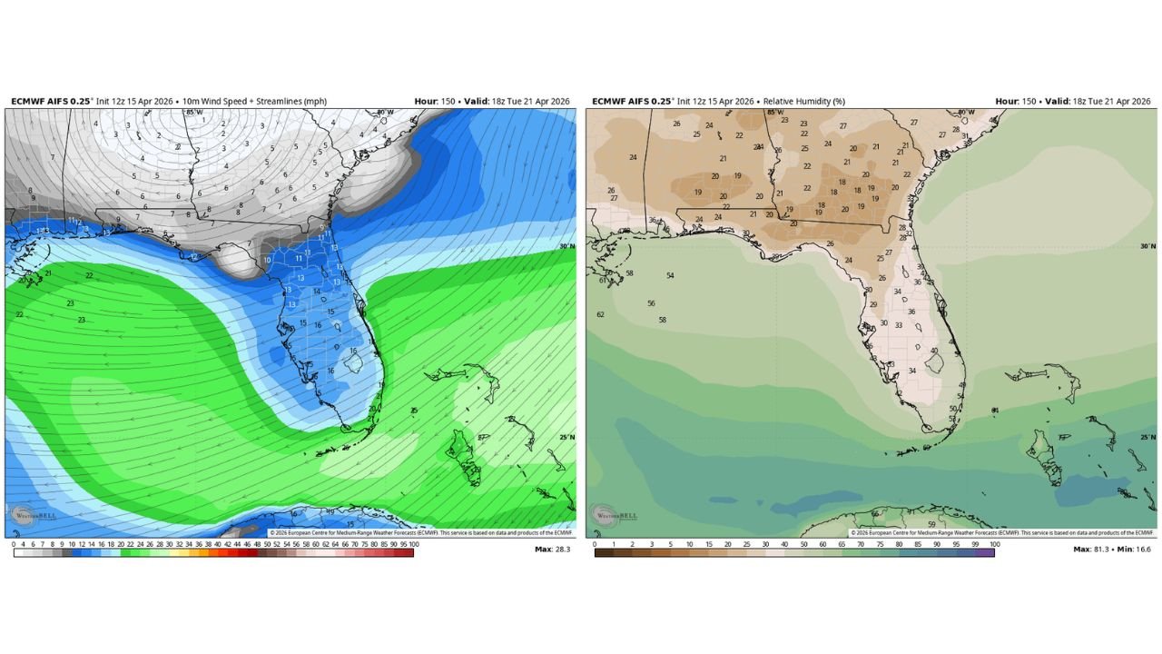
A cold front is set to push through Florida on Monday, and what comes right behind it is the real concern. Relative humidity levels are expected to crash to below 40% across much of the Peninsula — and in some interior areas, readings could drop as low as 18 to 20%. Combine that with sustained winds, and the conditions are almost textbook for fast-moving fires.
Areas Most at Risk Tuesday
- Florida: Orlando, Tampa, Gainesville, Ocala, Lakeland, and much of the central Peninsula
- Florida: Jacksonville and Northeast Florida corridor with humidity dipping into the low 20s
- Florida: South Florida including Fort Myers and Naples with RH near 34–40% and winds touching 16 mph
- Alabama and Georgia: Southern portions seeing relative humidity in the 18–22% range — borderline critical
Why Tuesday Is the Dangerous Day
A cold front arrives Monday and does what cold fronts do in April — it dries everything out fast.
- Relative humidity dropping below 40% across the Florida Peninsula — well into fire weather territory
- Sustained winds of 15–20 mph keeping conditions active and spreading potential
- Lowest humidity values of 18–20% locked over interior and northern Florida through the afternoon hours
- Rapid fire spread risk on any existing dry brush, grass, or scrubland
What This Means for Central Florida
Central Florida knows this pattern well. April is historically one of the driest months on the Peninsula, and when a cold front punches through and northerly winds follow, the landscape dries out fast — sometimes within hours.
Areas around Orlando, Ocala, and the I-4 corridor sit in the heart of the risk zone Tuesday. The scrub and palmetto flatlands in this region can ignite quickly when relative humidity drops below 40% and winds are consistently blowing above 15 mph.
If you live near wooded areas, nature preserves, or open land in Central Florida — Tuesday is not the day to burn yard waste or operate anything that can throw a spark outdoors.
The Setup Leading Into the Weekend
The cold front moves through Monday and exits quickly. Behind it, a dry airmass settles over Florida for at least Tuesday before moisture slowly begins returning from the south later in the week.
Wednesday onward, relative humidity values are expected to recover somewhat, and wind speeds should ease. But Tuesday’s window — roughly the afternoon hours — represents the peak danger period for the Florida Peninsula. Fire weather alerts from local authorities are possible and residents should monitor conditions closely that day.
What to Watch Before Tuesday
- Monday cold front passage — timing will determine exactly when Tuesday’s dry air locks in
- Official fire weather watches or warnings — local emergency managers may issue alerts Monday night
- Afternoon wind gusts Tuesday — even brief gusts above 20 mph can dramatically increase spread risk
- Air quality reports — if fires ignite, smoke can affect communities miles away
- Humidity recovery timeline — watch for moisture returning Wednesday to signal the threat is easing
Residents across the Florida Peninsula — especially in rural, wooded, or coastal scrub areas — should stay alert Tuesday and avoid any outdoor burning or fire-related activity until conditions improve.
WaldronNews.com will continue tracking this developing fire weather threat and provide updates as Tuesday’s conditions become clearer.