
Washington DC and Baltimore Just Broke April Heat Records as the Region Hits 90 Degrees for the 10th Time This Year — Second Most Ever Recorded
WASHINGTON, D.C. — History was made Wednesday afternoon across the Washington D.C., Baltimore, and broader mid-Atlantic region as temperatures soared to record-breaking levels and the nation’s capital tied an all-time date record while surrounding cities shattered theirs entirely.
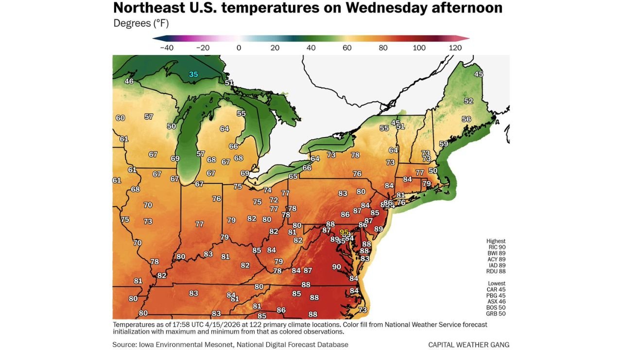
By 2:00 PM Wednesday, the numbers told the story. Washington D.C. hit 89 degrees, Dulles Airport reached 89 degrees, and Baltimore pushed to 90 degrees — making this the hottest day of 2026 so far across the region. D.C. tied its record high for the date. Baltimore and Dulles both set brand new records.
But the most remarkable statistic of this heat event is not just today’s temperature. Wednesday marked the 10th day this year that Washington D.C. has recorded a high of 80 degrees or above. That is the second most on record for this point in the calendar year, trailing only 11 such days in 1945. The average number of 80-degree days by mid-April in D.C. is about three. The region has now seen more than three times that total, and spring is barely half over.
How Hot It Got Across the Region Wednesday
The temperature map as of Wednesday afternoon shows just how concentrated the extreme heat is across the mid-Atlantic:
Record breakers:
- Richmond, Virginia: 90 degrees — highest reading in the entire region
- Baltimore: 89 degrees — new record for the date
- Atlantic City: 89 degrees — new record
- Dulles Airport: 89 degrees — new record
- Washington D.C. (National): Approaching 90 degrees — tied the date record, with the Potomac River keeping temperatures slightly moderated at the official observation point
- Raleigh, North Carolina: 88 degrees
If D.C.’s official National Airport station hits 90 degrees Wednesday, it will be the earliest 90-degree reading since April 10, 2013 at that location.
The broader heat footprint: Temperatures across the entire mid-Atlantic coast are running in the mid to upper 80s with the core heat concentrated between Washington, Baltimore, and Richmond. Moving north, Philadelphia is in the mid 80s, New York is in the upper 70s to low 80s, and Boston sits in the low 50s as a cooler air mass holds on to the north.
The contrast on the temperature map is striking. While D.C. bakes at 95 degrees in some spots, northern Maine and Quebec are sitting at 45 to 46 degrees. The country is split into two completely different seasons depending on where you live Wednesday afternoon.
Why This Heat Event Is Historically Significant
Ten days of 80-degree or higher temperatures before mid-April in Washington D.C. is not just impressive. It is nearly unprecedented in the modern record. The only year that tops it is 1945, when the D.C. area recorded 11 such days by this point in the calendar year.
To put that in perspective — in a typical April, D.C. averages roughly three days at or above 80 degrees total. The region has blown past that in just the first two weeks of the month and is now approaching a record that has stood for more than 80 years.
The heat this week is being driven by a dominant upper-level ridge sitting over the eastern United States, forcing temperatures well above seasonal norms across the entire mid-Atlantic and Southeast. The same pattern that produced record April highs earlier this week across the D.C. corridor is responsible for Wednesday’s record-breaking afternoon readings from Richmond to Baltimore to Dulles.
Relief Is Coming — But Not Yet
Wednesday represents the peak of this heat event for Washington D.C. and the surrounding mid-Atlantic region. A cold front is tracking toward the area and will bring a significant temperature drop by the weekend, ending the extraordinary run of April heat that has defined the past two weeks across the region.
Until that front arrives, residents across D.C., Baltimore, Richmond, and the broader mid-Atlantic should continue treating the heat seriously. Ten consecutive days of 80-degree heat in mid-April — before the body has had time to fully acclimate to warm weather — carries real health risks, particularly for elderly residents, outdoor workers, and anyone without reliable cooling.
What to Watch
Temperatures across the D.C. and Baltimore corridor will remain warm through at least Thursday before the approaching front begins to erode the heat ridge. Keep an eye on whether D.C.’s National Airport station officially hits 90 degrees before the day ends Wednesday — if it does, it locks in a historic date that weather historians will be talking about for years.
The front that ends this heat event arrives this weekend — and with it comes a dramatic cooldown that will feel like a completely different season compared to the record heat of this week.
WaldronNews.com will continue tracking the historic April heat across Washington D.C., Baltimore, and the mid-Atlantic region and will provide updates as the weekend cooldown approaches.