
Birmingham Hits 89 Degrees Friday Before a 40 Degree Temperature Crash This Weekend — Here Is Alabama’s Full Weather Picture Through Late April
BIRMINGHAM, Alabama — If it felt like summer arrived early in Alabama this week, that is because it essentially did. Friday is the last big heat day before a cold front arrives this weekend and sends temperatures tumbling nearly 40 degrees in less than 48 hours. Here is everything Alabama residents need to know about the next 10 days.
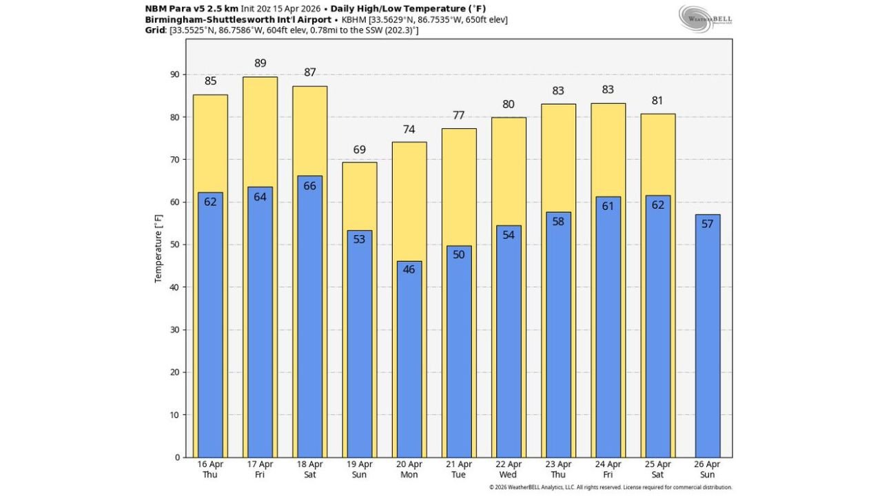
The Heat Through Saturday
Birmingham is running hot and Friday turns up the dial one final time before the pattern breaks.
Thursday brings a high of 85°F and Friday peaks at 89°F with some spots across the state potentially touching 90 degrees during the afternoon. Saturday stays warm with highs between 85 and 87°F through the afternoon before the cold front changes everything Saturday night.
Do not let Saturday’s warmth fool you. A front is on its way and the evening hours will tell a completely different story.
Saturday Night Into Sunday
A cold front pushes through Alabama Saturday night into Sunday morning bringing showers and a few thunderstorms. This is not a severe weather event. Rainfall totals will be light:
- Northwest Alabama gets the best chance, up to half an inch in some spots
- Most of Alabama sees a quarter inch or less
- South Alabama may not see enough rain to measure as the system fades Sunday afternoon
The 7-day precipitation map through April 22 tells the story clearly. Alabama sits in the dry fringe of this system while heavier totals of 0.5 to 1.0+ inches fall across Arkansas, Mississippi, and Tennessee to the northwest.
Sunday — The 40 Degree Crash
After Saturday’s near 90 degree afternoon, Sunday delivers a sharp reality check. The high drops to just 69°F and the overnight low falls to 46°F. That is a swing of nearly 40 degrees from Friday’s peak in less than 48 hours.
Northern Alabama feels it most with highs only in the mid 60s. That 46 degree morning after a week of summer warmth will feel genuinely cold. Anyone with garden plants or sensitive vegetation outside should cover them Saturday night.
Next Week Looks Pleasant
The first half of next week brings the nicest stretch of weather Alabama has seen in weeks:
- Monday: 69°F high, cool and dry
- Tuesday: 74°F, warming nicely
- Wednesday: 80°F, comfortable
- Thursday: 83°F, feeling warm again
- Friday: 83°F with humidity building
This dry and comfortable stretch from Monday through Thursday is a genuine break from both the extreme heat and storm threats that have defined April so far across the state.
Watch April 24 to 25
Signs of a pattern change are building for the end of next week. Rain and thunderstorms look likely to return to Alabama by Friday and Saturday, April 24 to 25 as the next system approaches.
Whether any severe weather comes with it is still too early to say with confidence. But the signal is consistent and residents should keep these dates on their radar.
Alabama is about to experience one of the sharpest weather reversals of the spring season before settling into a genuinely pleasant week ahead.
WaldronNews.com will continue tracking Alabama’s weather through the weekend front and the developing late April storm pattern and will provide updates as the April 24 to 25 timeline comes into focus.