
240 Storm Reports Hit Illinois, Iowa and Missouri on April 15 as Friday Threatens to Be Far Worse
CHICAGO, Illinois — A significant severe weather outbreak rolled across Illinois, Iowa, Missouri, and neighboring states on April 15, generating 240 total storm reports including 180 hail reports, 59 wind reports, and 1 tornado — and forecasters are now warning that what is coming this Friday, April 17 could make Tuesday’s event look minor by comparison.
The April 15 storm reports stretched from the Iowa-Missouri corridor up through Illinois and into the Great Lakes region, with large hail reports — stones measuring 2 inches or larger — scattered across a wide swath of the Midwest. But what has forecasters paying close attention is the comparison now being drawn between Tuesday’s outbreak and one of the most violent severe weather days in recent Midwest history.
Where Storm Reports Were Concentrated April 15
- Iowa: Central and southern Iowa bearing the heaviest concentration of wind and hail reports from Tuesday’s storms
- Illinois: Northern and central Illinois seeing a continuous line of severe reports pushing northeast through the day
- Missouri: Northern Missouri corridor hit with large hail and damaging wind reports through the afternoon
- Great Lakes region: Michigan, Ohio, and Pennsylvania picking up hail and wind reports as the system pushed east
- Mid-Atlantic: Pennsylvania and New York seeing the tail end of the storm system with scattered severe reports
What the Numbers From April 15 Actually Mean
Tuesday’s storm outbreak was significant on its own — 240 total reports across multiple states in a single day is a serious severe weather event by any measure.
- 180 hail reports with 22 reports of large hail measuring 2 inches or greater in diameter
- 59 wind reports of high wind events — with the threshold for this category starting at 65 knots (75 mph)
- 1 confirmed tornado report from Tuesday’s activity
- Storm corridor stretching from the Iowa-Missouri border all the way northeast into Pennsylvania and New York
That is a substantial outbreak. But the comparison being made to May 21, 2024 is what makes this week so alarming.
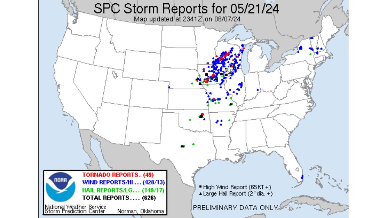
The May 21 2024 Comparison That Has People Worried
On May 21, 2024, the Midwest was hit by one of its most devastating severe weather days in years — 626 total storm reports, 49 confirmed tornadoes, 428 wind reports, and 149 large hail reports. That day caused widespread destruction across Wisconsin, Illinois, Michigan, and surrounding states.
Forecasters looking at Friday’s atmospheric setup are drawing a direct parallel between what the atmosphere looked like before May 21, 2024 and what it looks like heading into Friday, April 17, 2026.
The same region. The same ingredients. A nearly identical storm report footprint already established from Tuesday as a starting point — and Friday’s setup is being described as potentially even more loaded with energy than Tuesday’s event already was.
Why Friday Is the Day to Watch
Tuesday produced 240 reports with a relatively modest tornado count. The setup arriving Friday has significantly more instability, more powerful wind shear, and a more favorable overlap of dangerous ingredients across Wisconsin, Illinois, and Iowa — the exact same corridor that was devastated on May 21, 2024.
Chicago and northern Illinois sit directly in the zone where Friday’s storm activity is expected to push through. The difference between Tuesday’s 240 reports and May 2024’s 626 reports came down to exactly how well the ingredients overlapped on that day. Right now, Friday’s overlap looks dangerously similar to the worse of those two events.
What to Watch Between Now and Friday Evening
- Tornado watch issuance — watch for official watch boxes covering Illinois, Iowa, and Wisconsin through Friday afternoon
- Storm initiation timing — early afternoon development across Iowa and western Illinois will signal how organized Friday becomes
- Comparison to May 21 2024 track — storms following a similar northeast path put Chicago’s northern suburbs and Milwaukee in the direct firing line
- Hail size reports Friday — Tuesday already produced 22 large hail reports; Friday’s energy levels could push stones significantly larger
- Nighttime storm push — as storms move northeast into the evening, Illinois and Indiana residents need to stay alert well after dark
Residents across Illinois, Iowa, Wisconsin, and Missouri have seen what Tuesday’s storm system was capable of. Friday is shaping up to be a day that demands far more respect. Have your emergency plan ready, know where your safe shelter is, and do not wait until warnings are issued to take action.
WaldronNews.com will continue tracking the Friday severe weather threat and provide updates as this dangerous setup develops through the day.