
Severe Weather Outbreak Hits Again Today From Oklahoma to Iowa — Tornadoes, Large Hail and Damaging Winds Expected This Afternoon and Evening
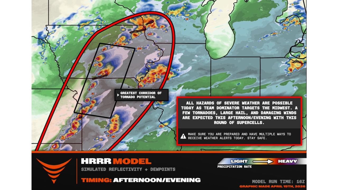
KANSAS CITY, Missouri — Another round of severe weather is firing up across the central United States this afternoon and evening, targeting a broad corridor from Oklahoma through Kansas, Missouri, Nebraska, and into Iowa as supercell thunderstorms develop along what forecasters are calling the greatest corridor of tornado potential for Wednesday, April 15, 2026.
The tornado threat today is lower than what the region saw earlier this week — but that does not mean it is gone. Any supercell that matures and moves into the 30-knot low-level jet in place across the region this afternoon carries a real chance of producing a tornado. Add in large hail and damaging winds and today qualifies as a full all-hazards severe weather day across the Oklahoma to Iowa corridor.
Where the Greatest Threat Is Focused
The red oval on today’s outlook map tells the story clearly. The greatest corridor of tornado potential is concentrated in a zone stretching from central Oklahoma and Kansas northeast through Nebraska and into Iowa. This is where the storm environment is most favorable for organized, rotating supercells this afternoon and evening.
Communities that need to be on alert today include:
- Oklahoma: Central and northern Oklahoma including the Oklahoma City metro
- Kansas: Wichita, Topeka, and the eastern Kansas corridor
- Nebraska: The southeast Nebraska communities along the storm corridor
- Iowa: Southern and central Iowa as storms push northeast through the evening hours
- Missouri: Western Missouri communities along the Kansas City corridor sit on the eastern edge of today’s primary threat zone
What Storms Will Bring
All severe weather hazards are on the table today across the Midwest target zone. Specifically:
Tornadoes are possible with any supercell that develops and matures into the low-level jet this afternoon. The tornado threat is not as elevated as it was during the extraordinary outbreak days of Monday and Tuesday, but it is real and present across the greatest corridor zone. A few tornadoes are expected with this round of storms.
Large hail is one of the more likely outcomes today as supercells tap into the available instability across the warm sector. Any storm that develops this afternoon has the potential to drop significant hail across the primary threat zone.
Damaging winds come with any organized severe thunderstorm in today’s environment. As storm activity increases and cells potentially grow upscale through the evening, the wind threat may become the dominant hazard across portions of the corridor later tonight.
Timing — Afternoon Into Evening
Storm development is expected to ramp up during the afternoon hours with the threat continuing into the evening. The window from roughly 3:00 PM through 9:00 PM is when conditions across the Oklahoma to Iowa corridor will be most dangerous. Residents should be alert and sheltered well before the late afternoon hours if they are inside the primary threat zone.
This Is the Third Consecutive Day of Severe Weather
What makes today particularly noteworthy is the context. This is yet another significant severe weather day for the central United States following the historic outbreak that unfolded Monday and Tuesday across Minnesota, Wisconsin, Iowa, and Illinois. The atmosphere has not finished cycling through dangerous setups, and communities from Oklahoma to Iowa are being asked to stay sharp and weather-aware for another full afternoon and evening of storm activity.
Severe weather fatigue is real after consecutive days of dangerous conditions — but the storms do not care about fatigue. Anyone in the primary threat corridor from Oklahoma City through Wichita, Kansas City, and into southern Iowa needs to treat today with the same urgency as any other severe weather day.
What You Need to Do Right Now
Have multiple ways to receive weather alerts active before 3:00 PM. That means your phone emergency alerts turned on, a weather app with push notifications running, and if possible a weather radio in your home. Do not rely on any single alert system during an active severe weather day.
Know where your shelter is before storms develop. The lowest floor interior room of your home away from windows is your target location the moment a tornado warning is issued for your county. Do not wait until you hear the storm to start moving.
If you are in the Oklahoma, Kansas, Nebraska, or Iowa corridor today, treat this afternoon as an active weather situation from the moment you wake up. Check conditions before heading out. Have a plan. Stay close to reliable weather information through the evening.
WaldronNews.com will continue tracking today’s severe weather outbreak across Oklahoma, Kansas, Nebraska, Missouri, and Iowa and will provide updates as storms develop, warnings are issued, and the situation evolves through this afternoon and evening.