
Iowa Just Got Added to the Tornado Threat Today — Here Is Why Central and Eastern Iowa Need to Watch the Sky This Afternoon
DES MOINES, Iowa — A tornado threat has just been added for Iowa on top of the already active severe weather situation unfolding today across Oklahoma and Missouri — and forecasters are calling it a sneaky one. A few storms could go supercellular this afternoon and evening across central and eastern Iowa, especially near the boundaries left behind by earlier rain and storm activity. If that happens, a couple of tornadoes become possible alongside large hail and damaging winds.
This is not the headliner threat today — that remains across Oklahoma and Missouri — but Iowa residents should not dismiss this. Sneaky tornado threats near outflow boundaries are historically some of the most difficult to warn for because they develop quickly and without the long lead times that more organized outbreaks provide.
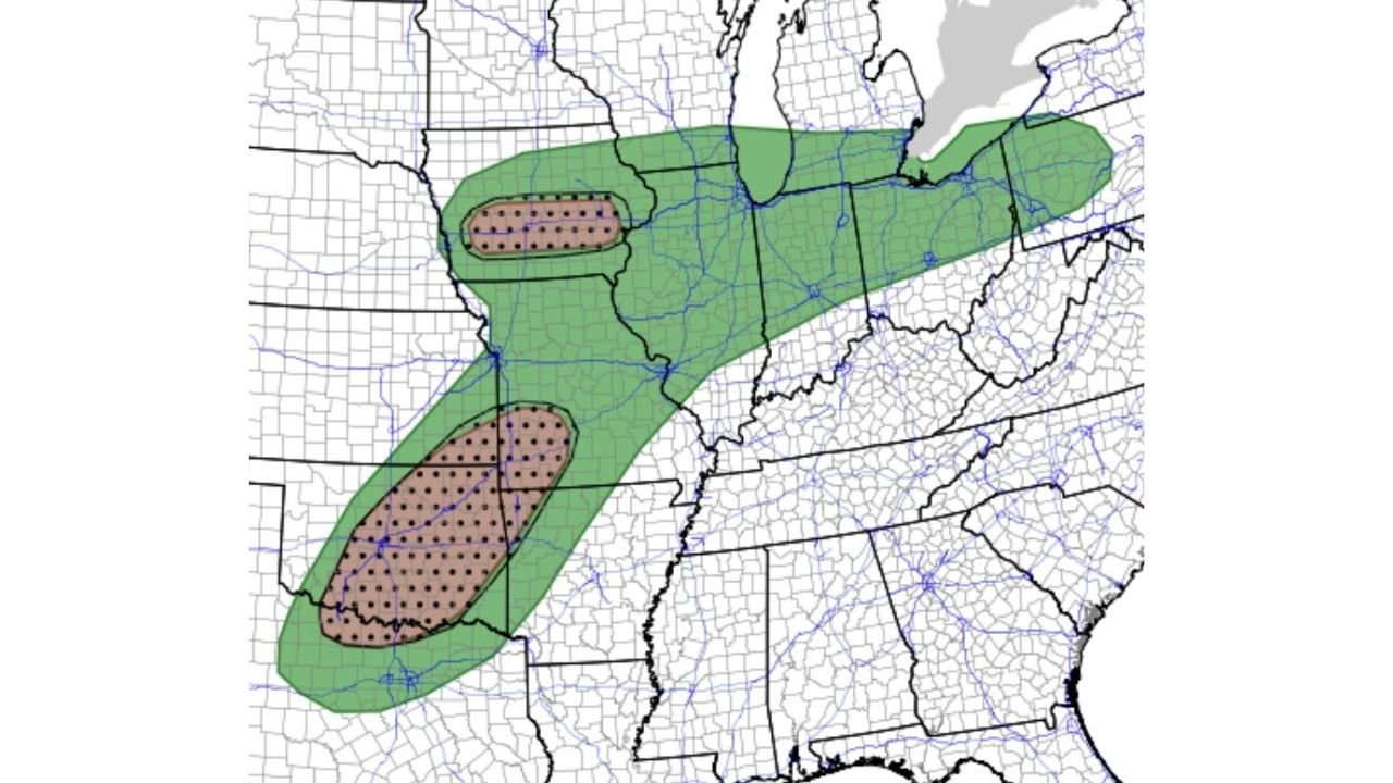
What the Outlook Map Shows
Two separate dotted tornado probability zones are now active on today’s outlook map:
The smaller northern zone sits across the Iowa and Illinois border region covering central and eastern Iowa communities. This is the newly added area where supercell development near old storm boundaries gives central Iowa its tornado chance this afternoon and evening.
The larger southern zone covers the primary and more significant threat area across Oklahoma, Kansas, and Missouri — where the greatest corridor of tornado potential has been focused all day. This zone carries higher tornado probability and covers a broader geographic area across the Southern Plains and lower Midwest.
Both zones sit inside the broader green marginal to slight risk area that stretches from the Southern Plains northeast through the Great Lakes corridor.
Why Iowa Is Being Added Now
The reason Iowa is being flagged mid-day is specific. Earlier rain and storm activity this morning left behind outflow boundaries — invisible atmospheric scars on the landscape where old storm downdrafts met the surface and changed the local wind direction. These boundaries are prime tornado triggers because they add extra low-level atmospheric spin that supercells can feed on.
If a storm that develops this afternoon moves across one of these leftover boundaries in central or eastern Iowa, it can suddenly and rapidly intensify its rotation beyond what the broader environment would otherwise support. This is what makes these setups sneaky — the tornado risk is not uniform across the state, it is concentrated along boundary zones that shift as the day progresses.
Where in Iowa Faces the Greatest Risk
The dotted zone on the northern portion of today’s map focuses the Iowa tornado threat on central and eastern Iowa specifically. Communities that need to be alert this afternoon and evening include:
Iowa: Des Moines, Ames, Iowa City, Cedar Rapids, Waterloo, and the broader central and eastern Iowa corridor sit within or near the area where supercell development and tornado production are possible this afternoon and evening.
The threat corridor also clips portions of northern Illinois along the Iowa border as the same boundary dynamics could support storm development across the tri-state area.
Oklahoma and Missouri Remain the Primary Concern
While Iowa gets added to the map today, the more significant and organized tornado threat remains across Oklahoma and Missouri. The larger dotted zone covering those states carries higher tornado probability, more organized storm development, and a more classic severe weather setup compared to Iowa’s more conditional and boundary-dependent risk.
Residents across Oklahoma City, Tulsa, Kansas City, and the Missouri corridor remain in the highest-risk zone for today’s outbreak and should already be on full alert with multiple warning systems active.
Iowa — What to Do Before 3 PM
The key thing about boundary-triggered tornado threats is the lack of warning time. A storm can go from ordinary to tornado-warned in minutes when it crosses a favorable boundary. That means Iowa residents cannot afford to wait until storms are on radar before thinking about shelter.
If you are in Des Moines, Iowa City, Cedar Rapids, or Waterloo, do these things right now:
Turn on weather alerts on your phone and make sure they are set loud. Know which room in your home or workplace is your shelter — lowest floor, interior, away from windows. Check radar at least every 30 minutes this afternoon. If a tornado warning pops up for your county, move immediately without hesitation.
The storm window across central and eastern Iowa runs through this afternoon and into the evening. Stay weather-aware until conditions improve tonight.
WaldronNews.com will continue tracking today’s tornado threat across Iowa, Oklahoma, and Missouri and will provide updates as storms develop and warnings are issued through this afternoon and evening.