
Is a Major Storm Outbreak Coming for Arkansas, Tennessee, Mississippi and Louisiana the Week of April 25?
LITTLE ROCK, Arkansas — The quiet weather that has blanketed the Southeastern United States for weeks is about to end, and the change arriving late next week could bring the most significant storm setup of the spring season for Arkansas, Tennessee, Mississippi, and Louisiana.
A large blocking high pressure system that has been sitting over the region — keeping storm chances bottled up and conditions dry — is expected to finally break down and move out late next week. When it leaves, it takes the lid off. The atmosphere across Dixie will be wide open for business by the time Saturday, April 25 arrives.
States and Cities in the Crosshairs
- Arkansas: Little Rock, Fort Smith, Texarkana — sitting near the core of the heaviest precipitation signal
- Louisiana: Shreveport, Baton Rouge, New Orleans — under the warm sector with intense rain rates possible
- Mississippi: Jackson, Hattiesburg, Tupelo — in the overlap zone between warm air and incoming energy
- Tennessee: Memphis, Nashville — heavy rain and storm activity spreading northeast through the state
- Kentucky: Louisville, Bowling Green — storm activity pushing into the region from the south and west
- Alabama and Georgia: Birmingham, Huntsville, Atlanta — watching the eastern edge of this system carefully
- Carolinas: Charlotte, Raleigh — lighter but widespread rain extending into the Mid-Atlantic corridor
What the Atmosphere Is Loading Up With
The setup taking shape for late next week has several dangerous ingredients trying to come together at the same time.
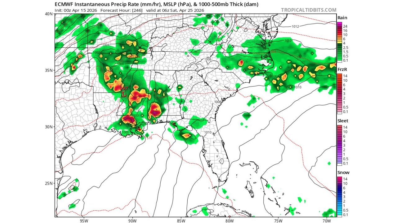
- Intense rainfall rates — deep red and yellow cores over Arkansas and Louisiana indicate rainfall of 10 to 24 mm per hour at peak — flash flood territory
- Strong low pressure near 1000 hPa diving into the Arkansas-Louisiana region, providing the lift needed to fire storms
- A sharp warm/cold air boundary cutting through the Gulf Coast — the exact zone where severe weather thrives in spring
- Widespread precipitation shield stretching from Arkansas all the way into the Carolinas — this is not a small or isolated event
Why This Week Matters for the South
When forecasters say “Dixie is open for business,” it means one specific thing — the classic Dixie Alley severe weather corridor running through Arkansas, Mississippi, Louisiana, Tennessee, and Alabama is primed and ready to produce.
Little Rock and the surrounding Arkansas River Valley sit almost exactly at the bullseye of where the heaviest rain rates are showing up. This region has seen devastating spring storms before, and the pattern shaping up for the week of April 25 carries similar atmospheric ingredients.
The honest answer right now is that forecasters are watching whether all these pieces — moisture, wind shear, instability, and a trigger — arrive at the same place at the same time. If they do, the Southeast could be looking at a serious severe weather outbreak. If even one ingredient is off, the threat drops significantly. That uncertainty is exactly why this week demands close attention.
How the Pattern Evolves Toward the Weekend
Right now through early next week, the blocking high keeps things relatively quiet. Rain chances remain low and temperatures stay warm but not volatile.
The change begins mid-week as the blocking high finally weakens and retreats. Energy dropping out of the northwest starts interacting with deep Gulf moisture streaming northward. By Friday into Saturday, April 25, the full setup locks in — low pressure deepens, the warm sector expands, and storms fire along and ahead of the approaching cold front. The intensity of what happens Saturday depends entirely on how well-timed the overlap of all these ingredients turns out to be.
What to Watch Over the Next 7 Days
- Blocking high departure timing — the sooner it leaves, the earlier the active pattern begins
- Gulf moisture return — watch for dew points climbing back into the 60s across Louisiana and Mississippi mid-week
- Low pressure track — whether it dives deep into Louisiana or stays over Arkansas shifts who gets the worst weather
- Severe weather watch or warning issuance — Friday night into Saturday morning is the critical window
- Flash flooding potential — rainfall rates are high enough that flooding is a serious parallel threat alongside any severe storms
Residents across Arkansas, Tennessee, Mississippi, Louisiana, and neighboring states should not wait until Friday to prepare. This is the week to check your emergency kit, know your local alerts, and have a plan ready.
WaldronNews.com will continue tracking this developing pattern change and provide updates as the April 25 storm setup becomes clearer.