
Tornado Warning Friday Wisconsin and Illinois as Supercell Risk Surges With CAPE Above 4000 and Violent Hodographs
MADISON, Wisconsin — A dangerous supercell and tornado threat is taking shape for Friday, April 17 across Wisconsin and parts of Illinois, as an explosive combination of atmospheric energy, powerful wind shear, and extreme instability lines up in a way that has forecasters paying very close attention.
The setup arriving Friday is not a routine storm day. The atmosphere across Wisconsin and northern Illinois is loading up with the kind of ingredients that produce long-track, violent tornadoes — and the timing puts the peak threat squarely during the afternoon and evening hours on Friday.
States and Cities That Need to Watch Friday
- Wisconsin: Madison, Milwaukee, Green Bay, Rockford corridor — directly in the path of the supercell risk zone
- Wisconsin: Central and southern counties facing the most concentrated severe threat through the afternoon
- Illinois: Northern Illinois including the Chicago metro area on the eastern edge of the storm corridor
- Iowa: Eastern Iowa counties watching the western flank of this system as storms develop and move northeast
- Indiana: Northwest Indiana could see activity push in during the late evening hours
What Makes This Setup So Alarming
This is not a marginal severe weather day. Every major ingredient for violent storm production is showing up at the same time.
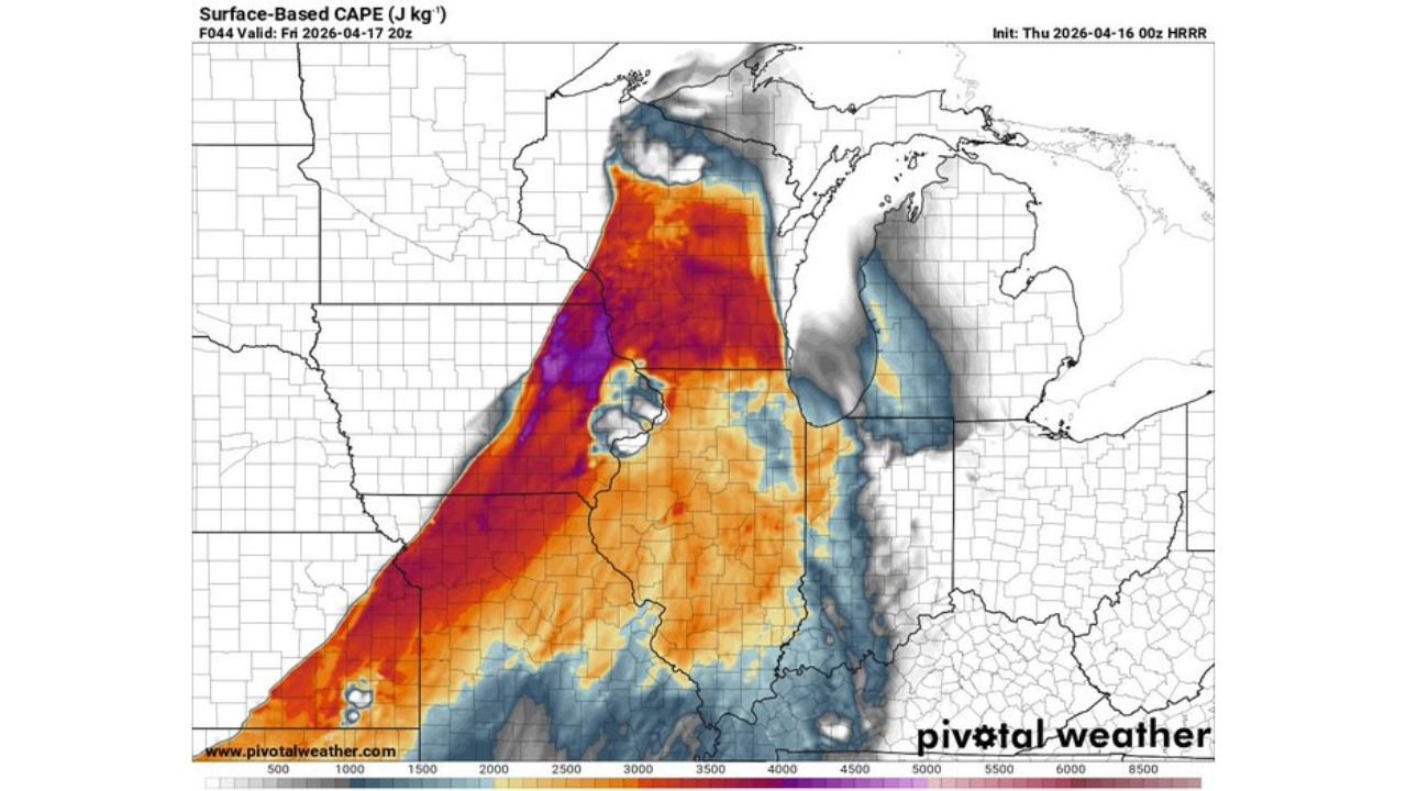
- Surface-based CAPE values exceeding 4,000 to 4,500 J/kg across southern Wisconsin and northern Illinois — that is an extraordinarily high amount of atmospheric fuel for mid-April in the Upper Midwest
- Purple zone on the instability map centered over the Wisconsin-Illinois border — the deepest, most explosive energy pocket in the entire setup
- Enlarged hodographs indicating exceptional wind shear through the atmosphere — the kind of rotation profiles that directly support supercell tornadoes
- Critical Angle of 70 degrees — a near-perfect alignment of low-level wind shear that dramatically increases the tornado production potential of any storm that fires
- Composite reflectivity showing intense storm cores — red and yellow radar signatures already indicated along a north-south corridor from Iowa through Wisconsin into the Great Lakes region
- Significant Tornado Parameter (STP) values running well above 1.0 — the threshold where tornado production from supercells becomes a serious concern
- 700 mb wind field showing a powerful jet of 50+ knot winds hammering directly into the storm zone — this is the upper-level support needed to sustain long-lived supercells
Why Wisconsin Should Take This Seriously Right Now
Madison sits almost exactly in the zone where the highest instability and the sharpest wind shear overlap on Friday afternoon. That overlap is the critical factor. You can have tremendous energy in the atmosphere, but without wind shear it does not organize. You can have great shear, but without instability storms struggle to sustain themselves. When both arrive together — as they appear to be doing Friday — the result is textbook supercell country.
Wisconsin does not see setups like this every spring. CAPE values pushing above 4,000 J/kg this far north in April is remarkable. The hodograph data is showing the kind of enlarged, curved shape that atmospheric scientists associate directly with tornado-producing supercells — not just garden-variety severe storms.
The sounding data valid Friday afternoon places the Lifted Condensation Level very low, meaning storms will have very short bases — another factor that favors tornado development and contact with the surface. The Storm Relative Helicity values are also running extremely high, adding yet another layer to an already dangerous profile.
How Friday’s Timeline Is Expected to Play Out
Through Friday morning, conditions remain relatively quiet as the atmosphere continues building its energy reserves. The setup needs daytime heating to fully destabilize, and that process begins in earnest through the late morning hours.
Storm initiation is expected during the early to mid afternoon across Iowa and western Wisconsin, with storms quickly organizing into supercell structures as they tap into the extreme instability pooling across the region. The most dangerous window — when fully organized supercells capable of producing significant tornadoes push through southern and central Wisconsin — appears to be between roughly 2 PM and 9 PM Friday local time.
As storms move northeast through the evening, northern Illinois and the Chicago metro area will need to watch closely for activity pushing into their area after dark. Nighttime tornadoes are significantly more dangerous because they are harder to see and warnings are harder to act on while people are asleep.
What to Watch Between Now and Friday Evening
- Tornado watches issued by Friday morning — watch for official watch boxes covering southern and central Wisconsin as the threat window approaches
- Supercell development over Iowa early Friday afternoon — the first storms to fire will tell forecasters a lot about how organized the threat becomes
- Storm motion and track — storms moving northeast put Madison, Milwaukee, and the Fox Valley directly in the path
- Evening and nighttime push into Illinois — Chicago metro and northern Illinois residents should stay alert well into Friday night
- Any tornado warnings — with this level of instability and shear, warnings could come with very little lead time if storms are moving fast
Every resident across Wisconsin and northern Illinois should have a reliable way to receive tornado warnings before Friday arrives — whether that is a weather app, NOAA weather radio, or local alerts on your phone. Do not wait until Friday morning to make a plan.
WaldronNews.com will continue tracking this rapidly developing severe weather threat and provide updates as Friday’s storm potential becomes clearer.