
Friday Could Bring a Widespread Severe Weather Outbreak Across Minnesota, Iowa, Kansas and Oklahoma as Three Separate Storm Threats Set Up for April 17
MINNEAPOLIS, Minnesota — Friday, April 17 is shaping up as a potentially significant severe weather day across a broad corridor from the Upper Midwest through the Central and Southern Plains — with three distinct and simultaneous storm development zones taking shape that could collectively produce strong tornadoes, large hail, and damaging winds across communities from Minneapolis and Cedar Rapids in the north through Kansas City, Oklahoma City, and Dallas in the south.
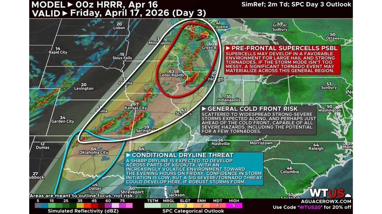
The setup features pre-frontal supercells in the Upper Midwest, a cold front risk across the central corridor, and a conditional dryline threat across Kansas, Oklahoma, and Texas — three separate and independently dangerous storm regimes that may all activate simultaneously during Friday afternoon and evening hours.
Three Storm Zones — Know Yours
ZONE 1 — Pre-Frontal Supercells — Minnesota, Wisconsin, Iowa, Illinois:
This is the zone with the highest significant tornado potential Friday. A volatile environment is setting up Friday afternoon and early evening across the Upper Midwest as a cold front oriented north-to-south creates ideal conditions for discrete supercell development once the cap breaks.
The red oval on the forecast map — centered over Minneapolis, Green Bay, Cedar Rapids, and the Chicago corridor — explicitly labels this zone as “Pre-Frontal Supercells Possible” with a favorable environment for large hail and strong tornadoes. If storm mode stays discrete rather than growing messy, forecasters say a significant tornado event may materialize across this general region Friday afternoon and evening.
Cities directly in this zone:
- Minnesota: Minneapolis and surrounding metro communities
- Wisconsin: Green Bay and eastern Wisconsin corridor
- Iowa: Cedar Rapids and eastern Iowa communities
- Illinois: Chicago corridor on the eastern edge of the pre-frontal supercell zone
The key uncertainty for Zone 1 is storm mode — strong forcing could push storms toward a messier, more linear organization that would limit the tornado threat while keeping hail and wind risks elevated. If storms stay discrete, this zone becomes the most dangerous corridor of Friday’s entire event.
ZONE 2 — General Cold Front Risk — Kansas City, St. Louis, Springfield:
The broad white oval covering the Kansas City, St. Louis, and Springfield corridor represents the General Cold Front Risk zone — where scattered to widespread strong and severe storms are expected along and just ahead of the cold front capable of all severe hazards including a few tornadoes.
Storms along the cold front in this zone may develop as early as late morning or early afternoon — earlier than the pre-frontal supercells to the north — but have a tendency to grow upscale into a messy cluster relatively quickly given the atmospheric shear configuration. Even in a more linear storm mode, these storms carry damaging wind, large hail, and tornado potential for communities across:
- Missouri: Kansas City, St. Louis, and Springfield
- Illinois — Central/Southern: Communities along the cold front corridor
- Indiana: Indianapolis and surrounding areas on the eastern extent
ZONE 3 — Conditional Dryline Threat — Kansas, Oklahoma, Texas:
The blue oval covering Oklahoma City, Dallas, and the Kansas-Oklahoma-Texas corridor represents a conditional but potentially significant severe weather threat. A sharp dryline is expected to develop across parts of Kansas, Oklahoma, and Texas during the afternoon — with the environment becoming increasingly volatile toward the evening hours.
Confidence in storm initiation along this dryline is described as low — meaning storms may or may not fire depending on how effectively the cap erodes. But if robust storms do develop here, a significant severe and tornado threat could emerge across:
- Kansas: Salina, Wichita, and the central Kansas corridor
- Oklahoma: Oklahoma City and the broader central Oklahoma dryline zone
- Texas: Dallas and north Texas communities on the southern end of the dryline
When storms do eventually develop along this dryline, they will initially be hail-dominant for the first hour or two — then as low-level shear intensifies during the evening hours, the tornado threat increases for any sustained storm that remains ongoing.
Why Friday Deserves Serious Attention Despite Being Two Days Out
Friday’s setup is being described as having the potential for a widespread severe weather outbreak — language that carries specific meaning in the meteorological community. The fact that three separate storm regimes are simultaneously active across such a wide geographic corridor means the overall footprint of severe weather Friday could be enormous even if individual zones perform below their peak potential.
The Upper Midwest pre-frontal supercell zone is currently considered the most favored area for significant and potentially violent tornado production — because the north-to-south cold front orientation in that region is the most favorable configuration for discrete, organized, long-lived rotating supercells. If storm mode cooperates and avoids becoming too messy, Friday could rival or exceed some of the significant severe weather days already seen during this extraordinary April 2026 outbreak sequence.
Both the Upper Midwest and Plains regimes are identified as the most favored areas for the most robust and potentially significant severe weather Friday — with the cold front zone in between carrying a more certain but potentially lower-ceiling threat.
What Changes Between Now and Friday
Two days of additional forecast data will significantly sharpen the picture for all three zones. The most important variables to watch:
Storm mode in the Upper Midwest — whether pre-frontal storms stay discrete or grow messy is the single biggest variable determining whether Friday produces a significant tornado outbreak or primarily a large hail and damaging wind event across Minnesota, Iowa, and Wisconsin.
Cold front timing in the Plains — if the cold front moves faster than currently projected, it could sweep away the warm sector ahead of the dryline before storms can develop across Kansas and Oklahoma, eliminating the Zone 3 conditional threat. If the front moves slower, the dryline setup has more time to load and the evening tornado threat in that zone increases.
What Friday Demands From You Right Now
Minneapolis, Cedar Rapids, Green Bay and Chicago corridor:
- You are in the pre-frontal supercell zone — the highest significant tornado potential area for Friday
- Begin identifying shelter locations and confirming weather alert systems today — do not wait until Friday morning
- Friday afternoon and early evening is your primary danger window
Kansas City, St. Louis and Springfield:
- Cold front storms may arrive as early as late morning Friday — earlier than typical afternoon severe weather events
- Have shelter plans ready before Friday morning and keep alerts active all day
Oklahoma City, Wichita and Dallas:
- The dryline threat is conditional but real — monitor Friday morning forecasts closely for any increase in confidence on storm initiation
- If storms develop Friday evening in your area they will carry all severe hazards
Friday is two days away — but the setup is already clear enough to demand preparation today across Minnesota, Iowa, Kansas, Oklahoma, Missouri, and Illinois.
WaldronNews.com will continue tracking Friday’s developing severe weather threat across the Plains and Midwest and will provide daily updates as forecast confidence increases heading into the event.