
The Midwest Is About to Turn Quieter — But the South and West Are Getting Soaked as Late April Pattern Splits the Country in Two
KANSAS CITY, Missouri — A dramatic split in the nation’s weather pattern is taking shape for late April and early May — and where you live will determine whether the final days of April bring welcome rainfall or a dry and disappointing close to what has been an extraordinarily active spring season across the central United States.
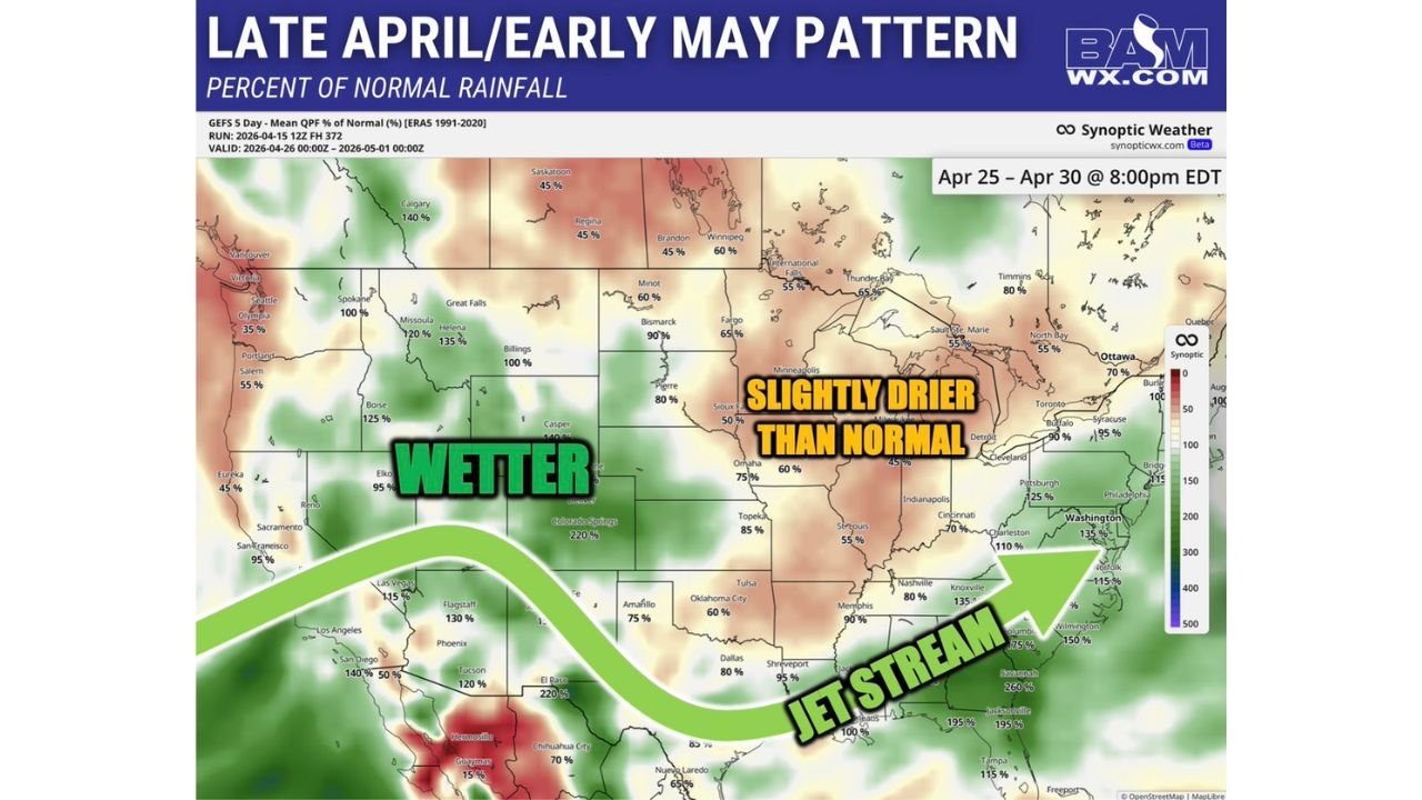
The pattern valid April 25 through April 30 shows moisture being shoved southward as a powerful jet stream carves a dividing line across the country — delivering above-normal and in some cases dramatically above-normal rainfall to the West, Southwest, Southern Plains, and Deep South, while the Midwest and Upper Plains settle into a slightly drier than normal period that signals the active first half of spring is finally winding down.
Who Gets Rain and Who Stays Dry — State by State
The Wetter Side — West, Southwest and South:
- Colorado Springs area: A striking 220% of normal rainfall — more than double the typical late April precipitation
- El Paso and southern New Mexico: Also showing 220% of normal — an extraordinary signal for a region that rarely sees this level of moisture
- Tucson, Arizona: 120% of normal rainfall
- Flagstaff: 130% of normal
- Las Vegas: 115% of normal — well above average for a desert city
- Dallas, Texas: 80% of normal — near average but on the wetter side
- Shreveport, Louisiana: 95% of normal
- Nashville, Tennessee: 80% of normal
- Knoxville: 135% of normal — a meaningful above-normal signal
- Memphis: 90% of normal
- Jacksonville, Florida: 195% of normal — nearly double normal rainfall
- Savannah area: 260% — one of the highest values on the entire map
- Columbia, South Carolina: 175% of normal
- Washington D.C.: 135% of normal
- Norfolk, Virginia: 115% of normal
- Pittsburgh: 125% of normal
- Philadelphia: 215% — an exceptional above-normal signal for the mid-Atlantic
- New York/Syracuse area: 95 to 100% — near normal
The Drier Side — Midwest and Upper Plains:
- Minneapolis: 50% of normal — notably dry for late April
- Sioux Falls: 50% of normal
- Fargo: 65% of normal
- Omaha: 75% of normal
- Topeka, Kansas: 85% of normal — trending toward normal but still below
- Indianapolis: 45% of normal — one of the driest signals in the entire map
- Cincinnati: 70% of normal
- St. Louis: 55% of normal
- Oklahoma City: 60% of normal
- Tulsa: 60% of normal
- Bismarck: 90% of normal — close to normal
Why This Split Is Happening
The answer is visible right on the map — a powerful jet stream is carving a broad arc across the country from the Pacific Northwest through the Southwest and across the Deep South toward the Atlantic Coast. This jet stream position is the atmospheric highway that storm systems follow, and its southward displacement during late April is what drives the dramatic rainfall contrast between the wet South and dry Midwest.
When the jet stream drops south like this, it pulls moisture and storm energy with it — delivering rain to communities along and south of its path while leaving the Midwest and Upper Plains in a relatively quiet and drier pattern above the jet. Minneapolis, Indianapolis, and St. Louis all find themselves on the dry side of this boundary during the April 25-30 window.
This pattern is consistent with what was predicted months ago — an active first half of spring for the Midwest followed by a quieter late spring period as the jet stream retreats southward and moisture gets shoved away from the region. The data is now confirming that forecast is verifying almost exactly as expected.
What This Means for Farmers Across the Region
Midwest farmers who were counting on late April rainfall to supplement what the active early spring delivered may find the final week of April disappointingly dry. Indianapolis at 45% of normal and Minneapolis at 50% of normal represent meaningful below-average signals that could leave fields drier than ideal heading into the critical early May planting window.
Southern Plains and Deep South farmers — particularly in Tennessee, the Carolinas, Georgia, and Florida — are in line for above-normal late April rainfall that could provide valuable soil moisture ahead of summer planting. Savannah at 260% and Jacksonville at 195% are particularly strong signals for the Deep South agricultural corridor.
Western farmers across Colorado, Arizona, and New Mexico face some of the most dramatically above-normal rainfall signals on the map — with Colorado Springs and El Paso both at 220% of normal. This level of late April moisture is exceptional for the Southwest and carries both agricultural benefits and flash flooding risks for communities in those regions.
What to Watch as Late April Approaches
- Midwest residents from Minneapolis and Omaha through Indianapolis and St. Louis — the quieter late April pattern means severe weather risk drops significantly compared to the extraordinary active stretch of early-to-mid April. Enjoy the relative calm but stay weather-aware as individual storm systems can still develop even in below-normal precipitation patterns
- Tennessee, Georgia, and the Carolinas — above-normal late April rainfall is coming your way. Knoxville at 135% and Savannah at 260% suggest meaningful storm and rain activity during the final week of April. Have weather alerts ready
- Philadelphia and the mid-Atlantic — a 215% of normal signal for late April is one of the strongest on the entire map for your region. Heavy rainfall events are possible during the April 25-30 window
- Colorado Springs and El Paso — 220% of normal rainfall signals carry flash flooding risk for communities in canyon and low-lying areas. Monitor local alerts closely during late April storm events
- Oklahoma City and Tulsa — sitting at 60% of normal, the Southern Plains dip into a drier-than-normal window during late April after an extraordinarily active early April severe weather period
The split is coming. Late April will look dramatically different depending on where you live — and the jet stream position now trending southward is the atmospheric force reshaping the nation’s rainfall map for the final days of spring.
WaldronNews.com will continue tracking late April and early May weather patterns across the United States and will provide updates as the jet stream position and rainfall forecasts are refined heading into the final week of April.