
Rain Is Finally Coming to the Southeast and Cotton Belt Next Week; Here Is What Alabama, Georgia and Mississippi Can Expect
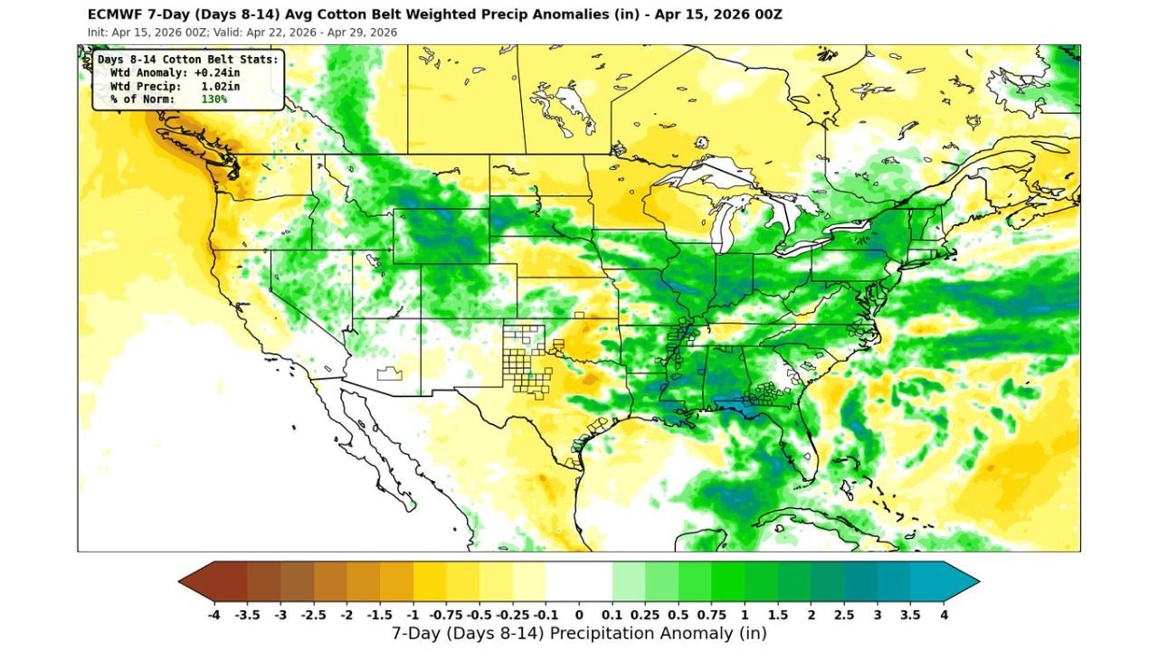
BIRMINGHAM, Alabama — After weeks of dry, warm, and frustrating conditions across the Southeast and Cotton Belt, meaningful rainfall relief is finally on the horizon — as a breaking Bermuda High opens the door for improved rain chances across Alabama, Georgia, Mississippi, Tennessee, and the broader Southeast during the April 22 through 29 window, with precipitation running at 130% of normal across the Cotton Belt during this period.
The 7-day weighted precipitation anomaly forecast covering Days 8 through 14 — valid April 22 through April 29, 2026 — shows a striking shift toward above-normal rainfall across the entire southeastern United States after weeks of a dominant high-pressure system that has been suppressing storm activity and keeping the region hot and dry.
Where the Rain Is Coming and How Much
The precipitation anomaly map tells a clear and encouraging story for the drought-stressed Southeast:
- Alabama: Deep green shading covers much of the state — indicating above-normal precipitation expected during the April 22-29 window. This is the most significant rainfall signal Alabama has seen in the forecast in weeks
- Mississippi: Similar above-normal green shading extends across Mississippi — farmers and communities that have been watching fields dry out through mid-April will finally see meaningful moisture return
- Georgia: Above-normal precipitation anomalies extend into Georgia — particularly across the northern and central portions of the state
- Tennessee: Green anomaly shading extends into Tennessee — with the mid-state corridor showing above-normal rainfall potential
- Louisiana and Arkansas: Both states show above-normal precipitation signals in the April 22-29 window
- The Carolinas: Above-normal rainfall extends into the Carolinas on the eastern edge of the moisture return pattern
- Cotton Belt weighted stats: The overall Cotton Belt precipitation is forecast at 1.02 inches weighted with a +0.24 inch anomaly — running at 130% of normal for the period
Why the Bermuda High Breaking Down Matters
The Bermuda High — a large area of high pressure that sits over the western Atlantic Ocean — has been the dominant weather controller across the Southeast for the past several weeks. When the Bermuda High is strong and well-positioned, it acts like a wall — blocking storm systems from penetrating into the Southeast and keeping the region locked in warm, dry, and increasingly drought-stressed conditions.
As the Bermuda High begins to break down, that blocking wall weakens — allowing moisture from the Gulf of Mexico to surge back into the Southeast and storm systems to finally reach the region with meaningful rainfall. This is a classic late-spring pattern shift that the Southeast desperately needs after the prolonged dry stretch of April.
The breakdown of the Bermuda High is not just good news for this week — it signals a broader pattern shift that could keep the Southeast in a more active and wetter weather regime heading into the final days of April and into early May.
What This Means for Farmers Across the Cotton Belt
The 130% of normal precipitation forecast for the Cotton Belt during April 22-29 is particularly significant for agriculture across Alabama, Mississippi, Georgia, and the broader Deep South. Cotton planting season is approaching rapidly, and soil moisture deficits that have been building across the region through mid-April have been creating increasingly stressful conditions for early-season crop establishment.
A return to above-normal rainfall during the final week of April gives Cotton Belt farmers a critical window to recharge soil moisture before the most intensive planting period begins. However, farmers should note that the rainfall forecast represents weighted averages across the region — some areas will see more than the forecast average and some will see less depending on individual storm tracks during the period.
What to Watch as the Pattern Shift Approaches
- Monitor daily forecast updates through April 20-21 as the Bermuda High breakdown becomes clearer and individual storm timing sharpens for the April 22-29 window
- Alabama and Mississippi communities that have been dealing with the driest conditions should watch for the first rain chances to arrive around April 22 as the pattern shift begins
- The Great Lakes and Midwest corridor shows green above-normal precipitation anomalies as well — confirming this is a broad national pattern shift, not just a regional event
- Some areas of above-normal dryness remain visible in the southern Plains and parts of Texas — meaning not every drought-stressed region benefits equally from this pattern change
- Cotton Belt farmers should be prepared for the possibility of heavy rainfall events within the above-normal signal — above-average totals sometimes arrive in concentrated bursts rather than steady light rain
The dry stretch that has plagued the Southeast and Cotton Belt through mid-April is approaching its end. The atmosphere is finally shifting, the Bermuda High is breaking down, and Alabama, Mississippi, Georgia, and Tennessee are in line for the rainfall they have been waiting weeks to receive.
WaldronNews.com will continue tracking the Southeast rainfall pattern shift and will provide updates as the April 22-29 storm and rain window approaches across the Cotton Belt and broader southeastern United States.