
Tornado Risk Upgraded for Madison, Milwaukee, Rockford and Cedar Rapids as Tuesday Hot Spot Identifies Highest Probability and Strongest Tornado Potential Directly Over Southern Wisconsin and Northern Illinois
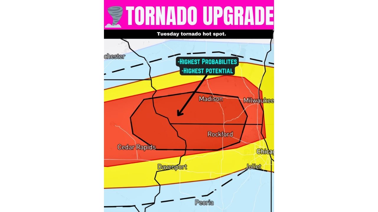
MADISON, Wisconsin — The tornado risk across southern Wisconsin and northern Illinois has been officially upgraded — and a newly defined Tuesday tornado hot spot is now pinpointing the zone where both the highest tornado probability AND the strongest tornado potential overlap simultaneously — centered directly over Madison and Milwaukee, Wisconsin through Rockford, Illinois and extending west toward Cedar Rapids and Davenport, Iowa.
The upgrade is serious and the geographic targeting is specific. The black outline zone — sitting inside the broader Level 3 red tornado risk area — identifies the precise corridor where tornadoes that form will not just be more likely but could also be stronger than anywhere else in today’s outbreak. This is the overlap of maximum probability and maximum intensity — the most dangerous single zone on today’s severe weather map.
Understanding Today’s Tornado Risk Zones — What Each Color Means
Red Zone — Level 3 of 5 — Highest Tornado Probability: The broad red area covering Cedar Rapids, Davenport, Madison, Milwaukee, Rockford, and surrounding communities represents the zone with the highest probability that a tornado happens nearby. A Level 3 tornado risk means this area has a meaningfully elevated chance of tornado occurrence — but it is important to understand what this means and does not mean. It does not mean a tornado will hit every house, every town, or every county inside the red zone. It means the probability of a tornado occurring within 25 miles of any point in this area is significantly elevated — higher than anywhere else in today’s outbreak.
Black Outline — Intensity Ceiling Is Higher Here: The black outlined polygon sitting inside the red zone and centered on Madison through Rockford is the most alarming designation on today’s map. This black outline explicitly identifies the zone where tornadoes that form COULD be stronger than those forming elsewhere in the red area. It is a way of pinpointing where the highest tornado probability and highest tornado intensity potential overlap — making the area inside the black outline the single most dangerous corridor for both tornado occurrence and tornado strength on today’s map. Madison, Milwaukee, and Rockford all sit inside or adjacent to this black outlined intensity zone.
Yellow Zone — Level 2 of 5 — Reasonable Tornado Chances: The yellow zone surrounding the red core covers a broader area including Chicago, Joliet, Peoria, and the outer corridor communities. Level 2 means less probability than the red zone — but still reasonable chances that warrant continued attention. Forecasters note that small changes and shifts in the storm pattern can cause this risk level to increase — meaning yellow zone communities should not treat their designation as a signal of safety.
Blue Zone — Level 1 of 5 — Low But Not Zero: The outermost blue zone extends into the broader surrounding region. Tornadoes are much less likely here — but the probability is explicitly not zero, and blue zone residents should maintain awareness throughout the afternoon and evening.
The Tuesday Tornado Hot Spot — Madison, Milwaukee and Rockford
The Tuesday tornado hot spot map makes the geographic target unmistakably clear. The black intensity outline centers on a corridor running from western Iowa through Cedar Rapids and Davenport northeast into Madison, Wisconsin and extending east through Rockford, Illinois to Milwaukee — this is where today’s outbreak will be most dangerous if supercells develop as expected.
Madison, Wisconsin sits squarely inside both the red Level 3 probability zone and the black intensity outline — meaning it faces both the highest likelihood of a tornado occurring nearby AND the highest potential for that tornado to be a strong or violent one of any community on today’s map.
Milwaukee, Wisconsin sits on the eastern edge of the black intensity outline — placing it inside the zone where stronger tornadoes are possible while also sitting within the high-probability red zone.
Rockford, Illinois falls directly inside the black intensity zone — another densely populated community facing the worst combination of tornado probability and tornado intensity potential on today’s map.
Cedar Rapids and Davenport, Iowa sit at the western end of the red zone and are included in the broader high-probability corridor — facing meaningful tornado risk as storms develop along the warm front and push northeast through the region.
Chicago and Joliet sit in the yellow Level 2 zone — still facing reasonable tornado chances but with lower probability than the red zone communities to their northwest.
Why the Black Outline Zone Is So Significant
The black intensity outline is not a standard feature on most tornado outlooks. It appears specifically when forecasters have identified a geographic area where the atmospheric ingredients for strong to violent tornado production are most perfectly aligned — where the combination of low-level wind shear, instability, and storm-triggering mechanisms creates conditions capable of producing tornadoes that exceed what the broader red zone environment would support.
For Madison, Milwaukee, and Rockford — sitting inside or adjacent to this black outline — today’s tornado threat is not just about probability. It is about the potential intensity of any tornado that does develop. A storm operating in the black outline zone has access to the most favorable tornado-producing environment available today, and the tornadoes it produces are more likely to be long-track, intense, and destructive than storms operating anywhere else in the broader risk area.
What Madison, Milwaukee and Rockford Residents Must Do Immediately
Madison, Wisconsin — Inside both the red zone and black intensity outline:
- You are at the intersection of highest probability and highest intensity on today’s tornado map — this is the most serious designation possible for any community today
- Identify your lowest floor interior shelter room right now and be ready to move there the moment a tornado warning is issued
- Do not wait for the tornado to be visible — Madison is a densely populated city and tornado warnings here will require immediate action, not assessment
Milwaukee, Wisconsin — Red zone with black outline overlap:
- The black intensity outline extends to Milwaukee — treating this as a significant tornado day is not optional
- Vehicles must be under cover — very large hail accompanies today’s supercell threat and Milwaukee’s urban environment means widespread vehicle damage in any hail event
- Weather alerts must be active and audible throughout the afternoon and evening
Rockford, Illinois — Inside the black intensity outline:
- Rockford sits directly inside the highest-intensity tornado zone on today’s map
- Given the 5:00 to 7:00 PM storm development window for northern Illinois, be sheltered and alert before 5:00 PM
Cedar Rapids and Davenport, Iowa — Red zone:
- Eastern Iowa sits in the warm front zone where the earliest and potentially most organized supercells will develop today
- The 4:00 PM tornado window for this zone means preparation time is extremely limited — be ready now
Chicago and Joliet — Yellow zone:
- Level 2 is still a meaningful tornado risk — keep weather alerts active
- The yellow zone can trend toward red if storm mode improves — monitor updates closely through the afternoon
One Final Critical Point for Everyone in the Risk Zone
The data behind today’s upgrade is unambiguous. The tornado risk has really increased in both potential and likelihood — and the black intensity outline over Madison, Milwaukee, and Rockford represents the forecasting community’s best assessment of where today’s most dangerous and potentially violent tornadoes are most likely to occur.
Every resident in these communities has one job for the next several hours: know your shelter, have your alerts active, and be ready to move immediately when warnings are issued.
WaldronNews.com will continue providing live updates on today’s tornado outbreak across Wisconsin, Illinois, and Iowa and will immediately report tornado warnings and confirmed tornadoes as the afternoon and evening storm event unfolds.