
Breaking Afternoon Update for the Midwest as Clearing Skies Are Actually Raising the Tornado Threat Higher With Explosive Storm Development Now Becoming More Likely This Evening
CHICAGO, Illinois — A critical and counterintuitive afternoon update is emerging across the Midwest severe weather risk zone as of 2:50 PM CDT Tuesday, April 14 — clearing skies spreading across the Enhanced Risk area are not reducing today’s tornado threat. They are making it worse.
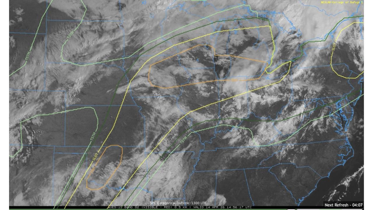
The visible satellite imagery valid at 2:50 PM CDT shows a significant amount of clearing ongoing across the risk zone — with sunlight now breaking through and reaching the surface across portions of the Midwest corridor. Under normal circumstances this might seem reassuring. Today it is not. The combination of high instability values already in place and clearing skies removing the cloud cover that was previously acting as a mixing brake means the atmosphere is now free to destabilize even further — and that destabilization is happening without the overmixing effect that would reduce tornado potential.
Why Clearing Skies Are a Tornado Threat Enhancer Today
The atmospheric dynamic at play this afternoon is specific and important for every resident in the risk zone to understand:
Overmixing occurs when too much sunshine reaches the surface too quickly — heating the lower atmosphere so aggressively that it destabilizes the temperature profile in a way that actually makes storm organization more difficult. Overmixing can paradoxically reduce tornado potential even in a high-instability environment by disrupting the low-level wind shear structure that rotating supercells depend on.
The partial cloud cover that remains across portions of the risk zone today is preventing that overmixing from occurring. The atmosphere is getting enough surface heating to continue building instability toward the already-high levels expected this afternoon — but the remaining cloud cover is acting as a natural brake that keeps the low-level wind profile intact and favorable for tornado production. This is sometimes called the “sweet spot” scenario — enough clearing to build instability, but not so much sunshine that the wind shear profile gets mixed out.
The bottom line from the satellite data is unambiguous — it will likely not take much to produce a tornado once storms develop this afternoon, and the clearing that is ongoing across the risk zone is making that development increasingly likely rather than less so.
What the Satellite Shows Across the Risk Zone
The visible satellite imagery at 2:50 PM CDT shows a complex and evolving cloud pattern across the Midwest:
The SPC Categorical Outlook contours overlaid on the satellite image — with orange Enhanced Risk and yellow Slight Risk boundaries clearly visible — confirm that the clearing is occurring directly within the highest-risk portions of today’s tornado threat zone. The partial clearing visible across the central portion of the image corresponds to portions of Iowa, Illinois, and Wisconsin — the exact area where the greatest tornado potential has been focused all day.
The remaining cloud cover visible across the northern and eastern portions of the risk zone provides the partial shading that is keeping the environment from overmixing — maintaining the favorable low-level wind shear structure that gives today’s storms their tornado-producing capability. This is not a weakening signal. This is the atmosphere setting itself up for an explosive afternoon and evening storm development scenario.
What This Means for Storm Development Timing
The clearing pattern visible on satellite at 2:50 PM CDT accelerates the timeline for afternoon storm development across the Midwest risk zone. As sunshine continues breaking through across Iowa, Illinois, and Wisconsin, surface temperatures will continue rising and instability will continue building toward the explosive levels expected by late afternoon.
This means storm initiation — the triggering of the first significant thunderstorms along today’s atmospheric boundaries — could begin earlier than previously anticipated across portions of the Enhanced Risk zone. Communities that were planning on a late afternoon or early evening storm arrival may find that the clearing skies this afternoon accelerate that timeline by one to two hours.
The favorable environment described in this update — clearing but not overmixing, high instability building, low-level wind shear intact — is precisely the scenario that produces the most dangerous and rapidly intensifying supercell thunderstorms. A storm that develops in this environment does not need hours to strengthen into a tornado-producing supercell. It can become dangerous within minutes of first development.
Immediate Action Required Across the Enhanced Risk Zone
This afternoon update carries an urgent message for every resident across the Chicago, Milwaukee, Detroit, Des Moines, Grand Rapids, and Indianapolis Enhanced Risk corridor:
The window to prepare is closing faster than expected. The clearing skies that are now spreading across the risk zone are advancing the storm development timeline — meaning the afternoon hours of 3:00 PM to 5:00 PM CDT are now a more active preparation window than previously anticipated.
- If you have not yet identified your shelter location — do it right now. Lowest floor, interior room, away from all windows. Know exactly where you are going before the first storm warning is issued
- If your vehicle is still outside — move it under covered parking immediately. Very large to giant hail remains explicitly on the table and clearing skies mean storm development is advancing
- Set every weather alert system you have to maximum sensitivity — phone emergency alerts, weather radio, and weather app push notifications all active simultaneously. Given the rapidly building instability and clearing skies, the first tornado warnings of the afternoon could come with very little additional notice
- Do not go outside to assess whether storms are forming — by the time a storm is visible on the horizon in today’s environment, it may already be producing a tornado
- Chicago, Milwaukee, and Des Moines metro residents — the clearing happening across your region right now is raising the tornado threat, not lowering it. The next two to four hours are the most critical preparation window of the entire day
The atmosphere across the Midwest is loading up for what forecasters said could approach Moderate Risk conditions — and the afternoon clearing that is now spreading across the risk zone is removing one of the last remaining atmospheric brakes on explosive storm development. Every resident from Des Moines to Chicago to Detroit needs to be fully prepared before the afternoon storm window arrives.
WaldronNews.com is monitoring this rapidly evolving situation across the Midwest and will provide immediate updates as storm development begins, tornado watches are issued, and the afternoon severe weather outbreak unfolds across the Enhanced Risk zone.