
North Carolina and South Carolina Mark 15 Years Since the April 16 2011 Tornado Outbreak That Sent 32 Twisters Tearing 55 Miles Through Raleigh and Fayetteville
RALEIGH, North Carolina — Fifteen years ago today, North Carolina experienced the single greatest one-day tornado outbreak in state history. On April 16, 2011, 30 confirmed tornadoes ripped across North Carolina in a matter of hours — EF3 monsters staying on the ground for over 55 miles, tearing through some of the most populated corridors in the state and leaving behind hundreds of millions of dollars in structural damage that communities spent years rebuilding from.
For anyone who lived through it in Raleigh, Fayetteville, Sanford, or Smithfield — this anniversary hits differently. This was not a distant storm. This was a day that changed how North Carolina thinks about tornado preparedness forever.
What April 16 2011 Looked Like Across North Carolina
The outbreak map tells the story more powerfully than words alone can. 30 total tornadoes touched down across North Carolina that single day — broken down by intensity as follows:
- EF0 tornadoes: 8 confirmed touchdowns across the state
- EF1 tornadoes: 9 confirmed — widespread damage to homes, trees, and power infrastructure
- EF2 tornadoes: 8 confirmed — significant structural damage across multiple counties
- EF3 tornadoes: 5 confirmed — the most violent storms of the outbreak, producing catastrophic damage along long continuous tracks
The Sanford-Raleigh EF3 and the Fayetteville-Smithfield EF3 were the signature storms of the day. Each stayed on the ground for over 55 miles — an extraordinarily long track for any tornado, let alone one cutting through densely populated areas of central North Carolina. The fatality numbers in individual counties reached as high as 12 confirmed deaths in a single county from a single storm track.
The Warning Barrage That Covered the Carolinas
The warning map from April 1 through April 30, 2011 across the Carolinas is something that forecasters and emergency managers still use as a reference point today. The density of tornado warnings and severe thunderstorm warnings issued across North Carolina, South Carolina, and into Virginia and Tennessee during that single month is described simply as a marathon — an unrelenting 3 to 4 week stretch of severe weather that pushed every warning system, every emergency team, and every community to its absolute limit.
The warning polygons covering Raleigh, Charlotte, Greensboro, Winston-Salem, Fayetteville, Wilmington, and Columbia during that April are so densely stacked they are nearly impossible to read on a map. Counties that had never seen tornado warnings issued so frequently in a single month were getting them day after day throughout April 2011.
April 2011 Was More Than Just One Day
As staggering as April 16 was on its own, it was only one chapter in what became the most historically significant month of severe weather the Carolinas had seen in modern times.
Just 11 days later, on April 27, 2011, the Super Outbreak struck — one of the largest tornado outbreaks ever recorded in United States history. The Tuscaloosa-Birmingham EF4 tornado in Alabama on that date remains one of the most studied and devastating storms in modern meteorological history. Its impacts were felt across the entire region the following morning.
North Carolina was hit again on April 27 as well — more tornadoes, more warnings, more communities scrambling for shelter. And woven throughout that same month were baseball sized hail events, northwest-flow supercells — a rare and particularly dangerous storm type — and a derecho that produced widespread wind damage across the region.
All of it in a single April. All of it 15 years ago this month.
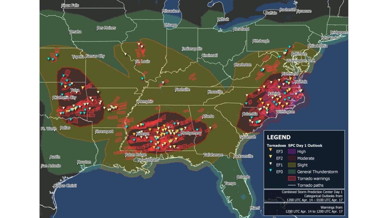
Where the Broader Outbreak Footprint Stretched
The combined storm report map from the broader April 14 through April 17 period shows just how wide the severe weather footprint was across the entire Southeast and Mid-Atlantic:
- North Carolina and South Carolina: The heaviest concentration of tornado warnings, EF2 and EF3 tornado tracks, and fatalities — the historical core of the outbreak
- Alabama and Mississippi: Montgomery, Jackson, Baton Rouge corridor seeing intense tornado activity with EF3 rated storms confirmed
- Virginia: Richmond, Norfolk, Raleigh corridor taking direct hits from storm systems pushing northeast
- Oklahoma and Texas: Oklahoma City, Tulsa, Dallas area seeing significant tornado activity in the western arm of the same broad outbreak pattern
- Tennessee: Memphis, Nashville, Knoxville corridors in the moderate risk zone with multiple tornado warnings issued
- Georgia and Louisiana: Atlanta, Shreveport, New Orleans on the southern flank of the outbreak footprint
Why This Anniversary Matters Right Now in 2026
The April 16, 2011 outbreak is not just a history lesson. It is the benchmark against which every spring severe weather season in North Carolina and the Carolinas is measured.
Raleigh has grown dramatically in the 15 years since those EF3 tornadoes cut through the region. Communities that were smaller in 2011 are now significantly more populated. More homes, more people, more exposure — sitting in the same geographic corridor that saw 55-mile tornado tracks in a single afternoon.
The atmospheric ingredients that produced April 16, 2011 are not unique to that year. They are the same ingredients that set up every spring across the Carolinas. The difference between a year with a historic outbreak and a year that passes quietly often comes down to timing, track, and how well communities are prepared when warnings go out.
What the 2011 Outbreak Taught North Carolina
- Long-track tornadoes are possible in North Carolina — the 55-mile EF3 tracks through Sanford, Raleigh, Fayetteville, and Smithfield proved that violent, sustained tornadoes are not just a Plains phenomenon
- Population centers are not immune — these storms hit highly populated areas directly, not just open farmland
- Warning fatigue is deadly — after weeks of severe weather in April 2011, some residents had begun treating warnings less seriously by the time the worst storms arrived
- Have a shelter plan before the season starts — the communities that fared best on April 16 were the ones that already knew exactly where to go when warnings sounded
- A single month can rewrite history — April 2011 produced benchmarks in North Carolina severe weather that are still referenced and studied 15 years later
Residents across North Carolina, South Carolina, and Virginia enter every spring severe weather season carrying the memory of what April 2011 looked like. That memory is not a reason for fear — it is a reason to be prepared before the first warning of the season is ever issued.
WaldronNews.com honors the communities affected by the April 16, 2011 outbreak and will continue covering severe weather threats across the Carolinas throughout the 2026 spring storm season.