
Arkansas Supercell and Baseball Sized Hail Threat Today 3 PM to 10 PM Targets Little Rock, Russellville and Hot Springs
LITTLE ROCK, Arkansas — Rotating supercells capable of producing golf ball to baseball sized hail are possible across central and western Arkansas today between 3 PM and 10 PM, and the scattered nature of this threat makes it one of the harder severe weather setups to pin down — which is exactly what makes it dangerous.
This is not going to be a wall-to-wall squall line rolling across the state. Instead, a few isolated but powerful storms are expected to fire up this afternoon, and any one of them could rapidly become a supercell capable of throwing down very large hail and producing rotation. When warnings are few and storms are isolated, it is easy to let your guard down — and that is the exact moment you cannot afford to.
Arkansas Cities in the Afternoon Threat Zone
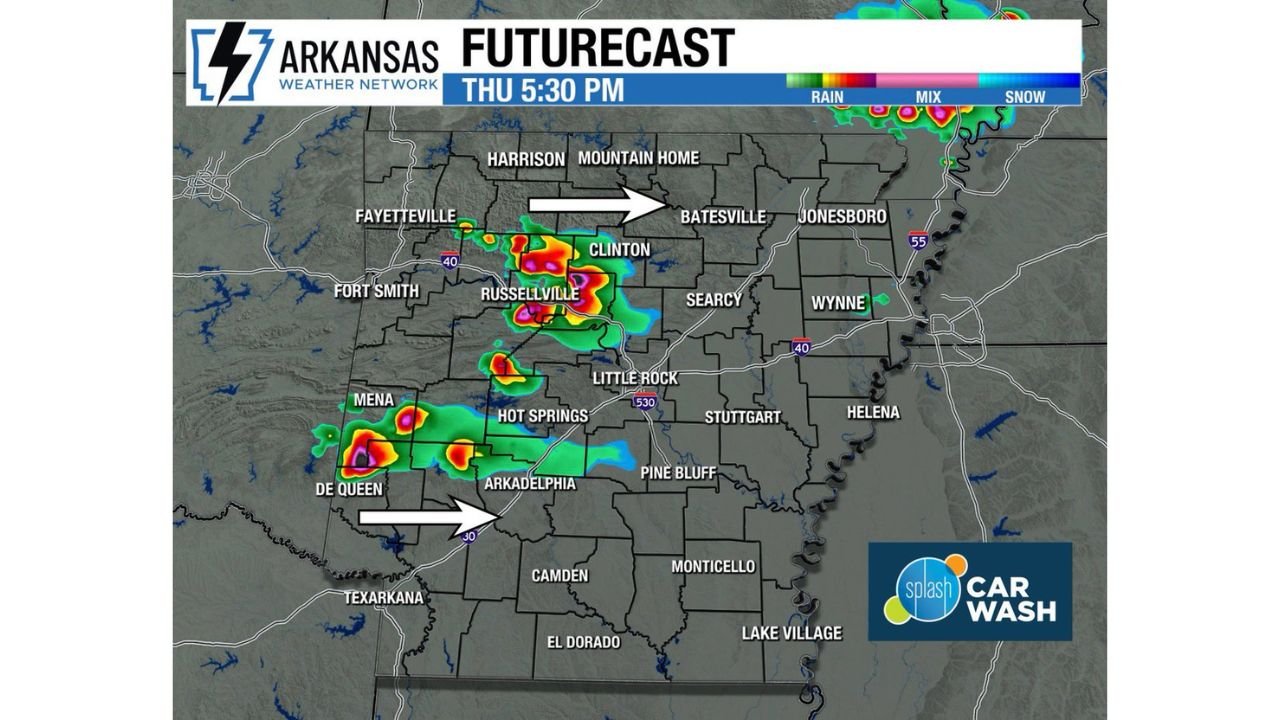
- Arkansas: Russellville and Clinton sitting directly under the heaviest storm core signal on the afternoon futurecast
- Arkansas: Little Rock and the surrounding metro area on the southern edge of the developing storm corridor
- Arkansas: Hot Springs and Arkadelphia watching intense storm cells approaching from the southwest through the afternoon
- Arkansas: Mena and De Queen in the southwest corner already seeing early storm development pushing eastward
- Arkansas: Fayetteville and Fort Smith on the western flank watching cells fire and track east along the I-40 corridor
- Arkansas: Batesville and Searcy on the northeastern edge as storms push through during the evening hours
What This Afternoon’s Storms Could Produce
The storm setup today is small in coverage but high in intensity potential for any cell that fires.
- Golf ball to baseball sized hail — stones ranging from 1.75 inches to 2.75 inches possible with any supercell that develops this afternoon
- Rotating storms — the atmosphere is loaded with enough wind shear to support supercell development in isolated storm clusters
- 3 PM to 10 PM danger window — peak threat during the late afternoon heating hours with activity continuing into the evening
- Very hard to forecast specific locations — because this is isolated storms and not a squall line, the difference between getting hit and seeing nothing could be just a few miles
Why Isolated Supercells Are So Dangerous
Here is the reality with today’s setup across Arkansas — a massive squall line of storms is actually easier for residents to track and prepare for. When a solid line of storms is coming, everyone knows it is coming and roughly when.
Isolated supercells are a completely different situation. They can fire quickly, intensify fast, and produce large hail and rotation before some residents even realize a storm is nearby. The forecast shows the storm cores already deep red and purple on radar over Russellville and pushing toward Clinton by Thursday evening — that is not light rain. That is a serious storm cell.
Little Rock sits just southeast of the primary development zone. Depending on storm motion and whether new cells fire farther south, the Little Rock metro could find itself under a severe thunderstorm or tornado warning with relatively short lead time this afternoon. The Hot Springs and Arkadelphia corridor is in a similar position — close enough to the action that any southward jog in storm track puts them directly in harm’s way.
The Window Tonight and What Comes After
The active period runs from 3 PM through 10 PM this evening. Storm initiation is expected to begin across western Arkansas — near Mena, De Queen, and the Fort Smith corridor — during the mid-afternoon hours as daytime heating peaks.
Those early storms will track eastward along and near the I-40 corridor, putting Russellville, Clinton, Conway, and eventually Little Rock in the path as the afternoon progresses. A second area of storm development near the Texarkana and Arkadelphia region could fire independently and push northeast through the early evening.
By 10 PM the energy begins to weaken and the threat gradually diminishes overnight as the atmosphere stabilizes. But the window between now and then deserves full attention.
What Arkansas Residents Need to Do Right Now
- Turn on weather alerts on your phone right now — today is an isolated storm day, meaning warnings could pop up fast with less advance notice than a typical squall line event
- Know your safe shelter location before 3 PM — interior room, lowest floor, away from windows — do not figure this out when the warning sounds
- If a warning is issued for your area, take it seriously immediately — isolated supercells move fast and the hail they produce can go from zero to baseball size quickly
- Move vehicles under cover if possible — golf ball to baseball sized hail will destroy an unprotected vehicle in minutes
- Check on family in Russellville, Clinton, Hot Springs and Little Rock — these communities are closest to the primary storm development zone this afternoon
- Stay weather aware through 10 PM — do not assume the threat is over at sunset
Any warning issued in Arkansas this afternoon and evening should be treated with full seriousness. The storms today may be few — but the ones that fire have everything they need to become dangerous very quickly.
WaldronNews.com will continue tracking today’s severe weather threat across Arkansas and provide updates as storms develop through the afternoon and evening hours.